
Ocean Floor Features
Multimedia
Lessons and Activities
Real World Data
Background Information
Career Profiles
Want to climb the tallest mountain on Earth? First you will need to climb into a deep ocean submersible and dive almost 4 miles under the surface of the Pacific Ocean to the sea floor.
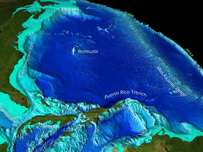
Over half a mile taller, from base to summit, than Mt. Everest, Mauna Kea in Hawaii is more than 6 miles tall from its base on the ocean floor, to its summit two miles above the surface of the Pacific Ocean. This island mountain is only one of many features found on the ocean floor. Besides being the base for islands, the ocean floor also includes continental shelves and slopes, canyons, oceanic ridges, trenches, fracture zones, abyssal hills, abyssal plains, volcanoes, and seamounts. Not just rock and mud, these locations are the sites of exotic ecosystems that have rarely been seen or even explored.
Plate Tectonics and the Ocean Floor
The shape of the ocean floor, its bathymetry, is largely a result of a process called plate tectonics. The outer rocky layer of the Earth includes about a dozen large sections called tectonic plates that are arranged like a spherical jig-saw puzzle floating on top of the Earth's hot flowing mantle. Convection currents in the molten mantle layer cause the plates to slowly move about the Earth (animation) a few centimeters each year. Many ocean floor features are a result of the interactions that occur at the edges of these plates.
The shifting plates may collide (converge), move away (diverge) or slide past (transform) each other. As plates converge, one plate may dive under the other causing earthquakes, forming volcanoes, or creating deep ocean trenches such as the Mariana Trench. Where plates are pulled away (diverge) from each other molten magma flows upward between the plates forming mid-ocean ridges, underwater volcanoes, hydrothermal vents, and new ocean floor crust. The Mid-Atlantic Ridge, is an example of this type of plate boundary. Transform boundaries are formed when two plates slide past one another such as on mid-ocean ridges and often cause earthquakes due to zig-zag offsets..
Marine Life and Exploration on the Ocean Floor
Over the last decade, more than 1500 new species have been discovered in the ocean by marine biologists and other ocean scientists. Many of these newly discovered species live deep on the ocean floor in unique habitats dependent on processes resulting from plate movement, underwater volcanoes, and cold water seeps. The discovery of deep ocean hydrothermal vent ecosystems in 1977 forced scientists to redefine living systems on our planet . Considered one of the most important scientific discoveries of the last century, living organisms in this deep, dark, ecosystem rely on chemicals and a process called chemosynthesis as the base of their food web and not on sunlight and photosynthesis as in other previously described ecosystems. Since this discovery, sonar, submarines, satellites, and robots have helped find and explore this type of ecosystem and other deep ocean formations around the globe. With only 5% of the Ocean explored, many more scientific discoveries await our future generations of explorers in this final unknown frontier of our planet Earth.
Education Connection
Helping students understand the connections between plate tectonics, ocean floor bathymetry, diversity of life, and adaptations to the environment can help increase their understanding of the interconnectedness of Earth Systems. Utilizing examples of current explorations of the unknown, and almost real-time discoveries can increase the relevance of studying the ocean floor and help increase students' excitement for learning. Ocean science is interdisciplinary and can be incorporated beyond the science classroom, for instance math teachers can use ocean data, graphs, and maps to provide relevance when studying concepts such as integers.
Collection Created December 2010
Features

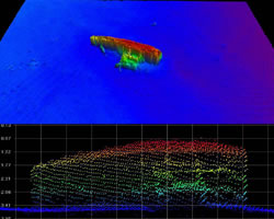
The Hidden World of Seamounts
May 2010 (National Ocean Service)
Making Waves podcast: Tune in to our extended interview with Dr. Peter Etnoyer, NOAA marine biologist, about the hidden world of seamounts. Documenting the abundance and variety of life on one single seamount, he said, is "like trying to describe a Monet painting from three bristles of a brush."...
Read More
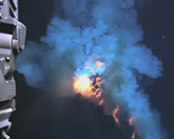
Discovery of a Deep Ocean Volcano
Dec 2009 (NOAA News)
"We found a type of lava never before seen erupting from an active volcano, and for the first time observed molten lava flowing across the deep-ocean seafloor"... "It was an underwater Fourth of July - a spectacular display of fireworks nearly 4,000 feet deep"...
Read More
Seeing the Sea Floor
Oct 2008 (NOAA)
Since human eyes cannot see into the ocean as they can through air, NOAA hydrographers rely on sound to look at the bottom. NOAA uses two kinds of echo sounding sonar equipment to map the sea floor: multibeam and side scan....
Read More