
Ocean Images

Looking for an easy way to view our images on your desktop computer or mobile device? Check out our Flickr gallery!
Select Your Category:


Latest Photos:

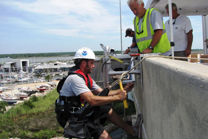
Staff from the Center for Operational Oceanographic Products and Services install a microwave radar water level sensor on the Dog River Bridge in Mobile County, Ala. This is one of five stations installed to support the County's storm surge monitoring network established in 2011.

Octopuses are boneless creatures. They are invertebrates with extremely flexible bodies that can squeeze through incredibly small spaces. An octopus has three hearts, nine brains, and blue blood. Two hearts pump blood to the gills, while a third circulates it to the rest of the body. The nervous system includes a central brain and a large ganglion at the base of each arm which controls movement. Octopus blood contains the copper-rich protein hemocyanin, which is more efficient than hemoglobin for oxygen transport at very low temperatures and low oxygen concentrations. Octopus, along with squid, cuttlefish, and nautalis, are cephalopods. Most of the hundreds of species of cephalopods have three hearts.


There are 21 Physical Oceanographic Real-Time Systems (PORTS®) located around the U.S. with the goal of supporting safe and efficient marine transportation.
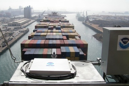

On June 20, 2012, the M/V Zhen Hua 13 delivered new cranes from China to the Port of Baltimore by navigating the waters of Chesapeake Bay. To reach this destination, the cranes had to clear a major obstacle—passing under the Chesapeake Bay Bridge outside of Annapolis. As the cranes slid under the bridge, the National Ocean Service provided air gap information as part of the Northern Chesapeake Bay Physical Oceanographic Real-Time System (PORTS®). These measurements, along with real-time tides and current data, helped to ensure a safe and early passage of the ship in to the Port of Baltimore.


An iceberg captured on camera during a 30-day mission in 2012 to map areas of the Arctic aboard the NOAA Ship Fairweather.


As multi-year sea ice continues to disappear at a rapid rate, vessel traffic in the Arctic is on the rise. NOAA is working to update Arctic nautical charts, add new tide and current monitoring stations, and conduct geodetic surveys to support safe navigation, national security, and economic growth in the region.


Polar bears have evolved to living in the extreme conditions of the Arctic. Polar bears and seals are dependent on sea ice for foraging, resting, and reproduction.


The NOAA Ship Thomas Jefferson prepares to bring aboard one of its launches after a day of hydrographic surveying in Long Island Sound. In 2012, the Thomas Jefferson and its two launches are working in a collaborative effort with the states of Connecticut and New York, to gather data that will help guide policy decisions about future uses of the sea floor, as well as to update nautical charts.


Starfish along the shore in Olympic Coast National Marine Sanctuary in Washington State. 2012 marks the 40th anniversary of the National Marine Sanctuaries Act, which established NOAA's National Marine Sanctuary system. Head to sanctuaries.noaa.gov for a link to a special website highlighting the top 40 accomplishments of the sanctuary system.


The wreck of the schooner E.B. Allen, located within Thunder Bay National Marine Sanctuary in Michigan. 2012 marks the 40th anniversary of the National Marine Sanctuaries Act, which established NOAA's National Marine Sanctuary system. Head to sanctuaries.noaa.gov for a link to a special website highlighting the top 40 accomplishments of the sanctuary system.


A manta ray in Flower Garden Banks National Marine Sanctuary off the coast of Florida. 2012 marks the 40th anniversary of the National Marine Sanctuaries Act, which established NOAA's National Marine Sanctuary system. Head to sanctuaries.noaa.gov for a link to a special website highlighting the top 40 accomplishments of the sanctuary system.


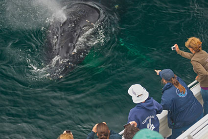
Channel Islands National Marine Sanctuary Naturalist Corps volunteers support a whale watching expedition. (Image courtesy of Bob Perry, Condor Express)

The NOAA Ship Fairweather is named after Mt. Fairweather, located in Alaska's Glacier Bay National Park and Preserve along the U.S.-Canada border. Mt. Fairweather was named by Captain Cook in 1778, presumably because of the good weather encountered at the time of his visit. Fairweather conducted a 2012 reconnaissance mission to help NOAA prioritize its efforts to update navigational charts in the Arctic.


NOAA’s newest survey vessel is the Ferninand R. Hassler. Hassler is a state-of-the-art coastal mapping vessel designed to detect and monitor changes to the sea floor. Data collected by the ship will be used to update nautical charts, detect potential hazards to navigation, and further enhance our understanding of the ever-changing marine environment.


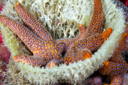
Two starfish 'hanging out' on a sponge in Gray's Reef National Marine Sanctuary, located off the coast of Georgia.

Sponges in Gray's Reef National Marine Sanctuary off the coast of Georgia. Within this sanctuary, there are rocky ledges with sponge and coral live bottom communities, as well as sandy bottom areas that are more typical of the seafloor off the southeastern U.S. coast.

- NOS Program Offices
- Center for Operational Oceanographic Products and Services
- National Centers for Coastal Ocean Science
- NOAA Coastal Services Center
- National Geodetic Survey
- Office of Coast Survey
- Office of National Marine Sanctuaries
- Office of Ocean and Coastal Resource Management
- Office of Response and Restoration

Revised 2013-02-12 | Questions, Comments? Contact Us | Report
Error | Disclaimer | About
the Site | User Survey
Web Site Owner: National Ocean Service | National Oceanic and Atmospheric
Administration |
Department of Commerce | USA.gov
http://oceanservice.noaa.gov