Please choose the quadrangle you would like to view. Files are in Adobe Portable Document Format (PDF), and you must have the free Adobe Acrobat Reader installed on your system to view them.
Color-Coded Topography and Shaded Relief Maps of the Moon
Lunar Orbiter Maps of the Moon
Index map courtesy of Ben Bussey, adapted from The Clementine Atlas of the Moon, Cambridge University Press.
Preface (revised June 25, 2009):
There are many excellent maps and atlases of the Moon in print and online, with each addressing a particular objective or community.
Some maps were created for lunar astronomical observers, some feature a specific type of image, and others
concentrate on global coverage or a particular region of the Moon.
However, none of these sources provides an up-to-date and comprehensive
picture of lunar
nomenclature. The lunar maps presented here have two purposes: (1) to bring together the
wealth of information on
the locations of named features on the Moon into a single source and (2) to keep
this source current so users have access to the most recent changes in lunar nomenclature.
At the time of this writing, there are 8,986 IAU-approved names in use on the Moon. These
names are of various feature types: catenae,
craters, dorsa, fossae, lacūs, landing site names,
maria, montes, oceanus, paludes, planitiae, promontoria, rimae, rupēs, lettered craters (called
"satellite features" in the Gazetteer of Planetary Nomenclature), sinūs, and valles.
The maps shown here include only names that are formally approved by the IAU and are
currently in use. The lettered crater names included in the Gazetteer of Planetary Nomenclature,
and therefore in this atlas, are found in the definitive source "NASA Catalogue of
Lunar Nomenclature" (NASA Reference Publication 1097). Over the decades, many informal names
have been used on the Moon and some IAU-approved names have been officially changed. Informal
names and names that have been changed are not shown. Cross references between these old
and new names have been noted in the "origin" field of the gazetteer. This is not a complete record of
cross references, only those discovered during the research for these maps.
These maps are kept up-to-date. As new names are approved by the IAU,
they will be added to the maps. If a name is dropped, it will be removed, and if a
feature is renamed, the new name will replace the old name.
Whenever there is a change to the lunar portion of the Gazetteer of Planetary Nomenclature,
that change will be shown on the corresponding map, and a
revision date will be added to the map. Changes to the gazetteer listings are
recorded in the "News" section on the title page of the gazetteer. The IAU name approval
process is also described in the gazetteer.
Questionable Names:
Great effort has been made to accurately place each name. The location of each name was
examined, sometimes in multiple sources, before inclusion. The locations of some feature
names were questionable because the names were not shown in the sources, or there is
conflicting information in the sources. These questionable cases were presented to lunar
nomenclature expert Ewen Whitaker, who
was able to provide a definitive answer in most
instances. For the remaining few questionable features, educated guesses were made based on
information in the sources, and coordinate and size information in the database.
The locations of the following lettered craters were verified by Ewen Whitaker.
The locations differ from what is shown in some printed atlases and maps, but Ewen's
location information is given precedence.
Barbier K (LAC 103)
Bolyai Q (LAC 117)
Büshing F (LAC 113)
Büshing H (LAC 113)
Buys-Ballot Q (LAC 50)
Condorcet N (LAC 63)
Dubyago G (LAC 62)
Cusanus E (LAC 5)
Galvani B (LAC 36)
Galvani D (LAC 36)
Galvani G (LAC 36)
Galvani H (LAC 36)
Galvani J (LAC 36)
Gauss J (LAC 28)
Gay-Lussac N (LAC 58)
Geiger K (LAC 103)
Gerard F (LAC 22)
Goldschmidt C (LAC 3)
Haret Y (LAC 132)
Hayn C (LAC 5)
Hayn T (LAC 5)
Hilbert A (LAC 100)
Houzeau P (LAC 107)
Houzeau Q (LAC 107)
Jenner Y (LAC 116)
Krasnov C (LAC 91)
Krasovskiy T (LAC 68)
La Pérouse A (LAC 81)
Lodygin M (LAC 106)
Lyot T (LAC 115)
Maurolycus N (LAC 113)
Milichius E (LAC 58)
Numerov G (LAC 142)
Perenago Z (LAC 54)
Petermann A (LAC 5)
Petermann X (LAC 5)
Petermann Y (LAC 5)
Pikel’ner S (LAC 130)
Pingré N (LAC 135)
Pingré Z (LAC 135)
Poncelet P (LAC 1)
Purkyně U (LAC 82)
Repsold A (LAC 10)
Repsold W (LAC 10)
Riccioli K (LAC 73)
Rumford F (LAC 105)
Schorr B (LAC 99)
Schrödinger G (LAC 140)
Schubert A (LAC 63)
Schwabe X (LAC 5)
Tikhomirov (LAC 49)
Valier P (LAC 68)
Vernadsky U (LAC 47)
Wöhler E (LAC 113)
Xenophanes F (LAC 10)
Zeno H (LAC 28)
Name Placement and Font:
Placement of names on the maps follows USGS cartographic standards. Names are placed inside craters if they
fit comfortably within the feature. If a name does not fit inside the feature, the next preferable location
is used: just outside the feature and to the right of it. If another name or another feature precludes
this positioning, the name is placed elsewhere outside the feature in a readable spot. For every name that is
placed outside of a crater, a dot is placed in the center of the crater so there is no question which crater
the name is associated with. For non-crater features, names are placed alongside or on the features. Some
craters are too small to be seen on the images; in these cases,
a note has been added indicating a larger-scale map that shows the feature, and where possible, a link to the
map has been added.
Most of these large scale maps are part of the NASA Lunar Topophotomap and Topographic Orthophotomap (LTO) series.
In most publications that include lettered craters, the 'parent' portion of the name has been omitted because
of limited space. For instance, Abenezra A is portrayed as just 'A.' Different methods have been used over the years to
show which parent crater the satellite crater belongs with. On some maps, letters are placed on the side of the
satellite crater that is closest to the parent crater, and at least one atlas uses font size to differentiate
these features. These methods help the reader to associate the lettered crater with the correct parent crater,
but the association is not always clear. The situation is especially unclear
in regions of the Moon where there are many of these lettered craters, or when the parent crater is located
on a different quadrangle than the satellite crater. For the maps presented here, the full name of each lettered crater has been
used in every case. For instance, the name 'Abenezra A' will be shown next to the feature, not just 'A,' so there
is no question about which parent crater the satellite crater belongs with. Satellite crater names are shown in
upper and lower case letters; all other crater names are shown in upper case letters.
Font color was chosen for readability only, and font size varies depending on the number of names in a region; in
crowded areas, the font size is smaller.
The user should not expect to see all of the names on a map by viewing at screen size or printing at page
size. Since these maps are digital products, the intention is for the user to change magnification to examine the named
features in an area of interest. The maps can be printed at page scale or document scale, which varies by map but is
usually about 30 inches by 30 inches.
Some IAU-approved names have alternate spellings shown in parentheses (see the list of lunar crater names in the Gazetteer of Planetary Nomenclature). The
preferred spellings have been used on these maps.
The boundaries of some features are not clear because the feature has been degraded or the image base does not show
the feature clearly. In these cases, approximate boundaries have been drawn with dotted lines.
Image Bases:
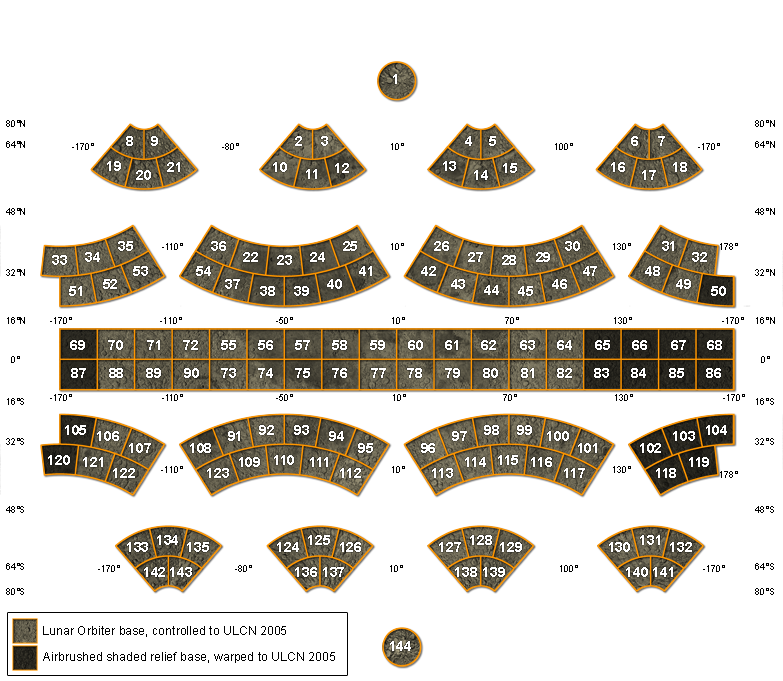
The Lunar Astronautical
Chart
(LAC) series divides the Moon into 144 quadrangles (36 Mercator, 106 Lambert Conformal, and 2 Polar
Stereographic quadrangles). The LAC chart format was chosen for this set of maps because
the LAC charts were widely distributed and used,
they are available online
at the Lunar and Planetary Institute, and the relatively small surface area covered by
each chart provides a file size that is easily downloaded and at the
same time provides enough detail to portray the nomenclature.
Positional information on the two map bases differs. The USGS color-coded shaded relief map shows
elevation data from the Clementine laser altimeter in the equatorial regions (Smith et al., 1997), and elevation
data collected photogrammetrically in the polar regions (Rosiek et al., 2001). This relief map was controlled to the Clementine
Lunar Control Network (CLCN; Davies, et al., 1994; Edwards et al.,
1996), with positional updates from Earth-based radar (Margot et al., 2000) and analyses of
Clementine stereo data (Cook et al., 2000). Note that some distortion of the shaded relief base was introduced when it was warped
to the CLCN; this distortion is pronounced in some areas at 1:1 million-scale. The CLCN (and therefore the
Clementine mosaic and related products, including the
base images used for these maps) was later found to have large horizontal errors, on average of
about 7 km, and in some areas perhaps as great as 20 km. Those errors have been
largely corrected with the Unified Lunar Control Network (ULCN) 2005 (Archinal et al., 2006), on
which the Lunar Orbiter global mosaic is based (Becker et al., 2005, 2008).
Note that because the two sets of maps use different control, the locations of the features are slightly shifted, and
features near or on the edges of maps might fall within different quadrangles. More information about
lunar control networks
and the Lunar Orbiter Digitization
Project can be found at the USGS Astrogeology page.
The Lunar Orbiter mosaic contains a data gap on the far side. The LAC quadrangles in the area of this gap (LACs 50, 65, 66, 67, 68, 69,
83, 84, 85, 86, 87, 102, 103, 104, 105, 118, 119, and 120) have as their image base the USGS airbrushed shaded relief mosaic, which has been
warped to the same control network as the LO mosaic, the ULCN 2005 (Hare et al., 2008). The warping process used for the shaded relief mosaic
is not as precise as the cartographically controlled LO mosaic, so there are slight mismatches at the borders of some quadrangles where
the LO image falls next to the shaded relief image.
Acknowledgements:
Special thanks go to Ewen Whitaker, who graciously and promptly consulted his extensive archives
to answer complicated questions about the locations of named features. Ryan Raub of the USGS (and Deborah Soltesz
and Brian Peck formerly of the USGS) are responsible for the design
and function of the web pages. Bonnie Redding, also of the USGS, provided image processing and cartographic skills. The members of the
IAU’s Working Group for Planetary System Nomenclature and its Task Groups have worked since the
early 1970s to provide a clear system of planetary nomenclature that represents cultures and countries from all
regions of Earth. This work was funded by the National Aeronautics and Space Administration,
through the Planetary Geology and Geophysics Program.
Feedback:
Please send comments regarding these maps, or planetary nomenclature in general,
to Jennifer Blue at jblue@usgs.gov.
Sources:
Books:
Andersson, L.E., and E.A. Whitaker, NASA Catalogue of Lunar Nomenclature, NASA Reference Publication 1097, October 1982.
Whitaker, E.A., Mapping and Naming the Moon, Cambridge University Press, Cambridge, 1999.
Atlases:
Bussey, B. and P.D. Spudis, The Clementine Atlas of the Moon, Cambridge University Press, Cambridge, 2004.
Byrne, Charles J., Lunar Orbiter Photographic Atlas of the Near Side of the Moon, Springer, London, 2005.
Gutschewski, G.L., D.C. Kinsler, and E. Whitaker, Atlas and Gazetteer of the Near Side of the Moon, NASA SP-241, Washington, D.C., 1971.
Rükl, A., Astronomy Atlas of the Moon, Kalmback Books, Wisconsin, 1990.
Whitaker, E.A., G.P. Kuiper, W.K. Hartmann, and L.H. Spreadley, Rectified Lunar Atlas, Supplement Number Two to the USAF Lunar Atlas.
Wilhelms, Don E., The Geologic History of the Moon, U.S. Geological Survey Professional Paper 1348, U.S. Government Printing Office, Washington, D.C., 1987.
Map Showing Relief and Surface Markings of the Lunar Far Side, 1:5,000,000, USGS I-1218-A, 1980.
Map Showing Relief and Surface Markings of the Lunar Polar Regions, 1:5,000,000, USGS I-1326-B, 1981.
Shaded Relief and Surface Markings of the Lunar Near Side, 1:5,000,000. USGS I-2276, 1992.
References:
Archinal, B.A., M.R. Rosiek, R.L. Kirk, and B.L. Redding, 2006, The Unified Lunar Control Network 2005, USGS Open File Report 2006-1367, http://pubs.usgs.gov/of/2006/1367/.
Arthur, D.W., et al., The System of Lunar Craters, Quadrant 1, Communications of the Lunar and Planetary Laboratory, Vol. 2, Number 30, 1963.
Arthur, D.W., et al., The System of Lunar Craters, Quadrant 2, Communications of the Lunar and Planetary Laboratory, Vol. 3, Number 40, 1964.
Arthur, D.W., et al., The System of Lunar Craters, Quadrant 3, Communications of the Lunar and Planetary Laboratory, Vol. 3, Number 50, 1965.
Arthur, D.W., et al., The System of Lunar Craters, Quadrant 4, Communications of the Lunar and Planetary Laboratory, Vol. 5, Number 70, 1966.
Becker, T., L. Weller, L. Gaddis, D. Soltesz, D. Cook, B. Archinal, A. Bennett, T. McDaniel, B. Redding, and J. Richie,
2005, Lunar Orbiter Revived: Update On Final Stages of Scanning, Archiving, and Cartographic Processing at USGS, LPS #1836,
abstract for Lunar and Planetary Science XXXVI (2005), http://www.lpi.usra.edu/meetings/lpsc2005/pdf/1836.pdf.
Cook, A., Watters, T.R., Robinson, M.S., Spudis, P.D., and Bussey, D.B.J., 2000, Lunar polar topography derived from Clementine stereoimages: Journal of Geophysical Research, v. 105, no. E5, p. 12,023-12,033.
Davies, M.E., T.R. Colvin, D.L. Meyer, and S. Nelson, 1994, The unified lunar control network: 1994 version, Journal of Geophysical Research, Vol. 99, No. E11, pages 23,211-23,214. November 25.
Edwards, K.E., T.R. Colvin, T.L. Becker, D. Cook, M.E. Davies, T.C. Duxbury, E.M. Eliason, E.M. Lee, A.S. McEwen, H. Morgan, M.S. Robinson, and T. Sorensen, 1996, "Global Digital Mapping of the Moon," Lunar Planet. Sci., XXVII: Houston, Lunar and Planetary Institute, 335.
Hare, T.M., B.A. Archinal, T.L. Becker, E.M. Lee, L.R. Gaddis, B.L. Redding, and M.R. Rosiek, 2008, Clementine Mosaics Warped to ULCN 2005 Network,
LPSC #2337, abstract for Lunar and Planetary Science XXXIX (2008), http://www.lpi.usra.edu/meetings/lpsc2008/pdf/2337.pdf.
Margot, J.L., Campbell, D.B., Jurgens, R.F., Slade, M.A., 2000, Digital elevation models of the Moon from Earth-based radar interferometry: IEEE Transactions on Geoscience and Remote Sensing, v. 38, no. 2, p. 1122-1133.
Rosiek, M.R., R.L. Kirk, and E.T. Howington-Kraus, 2001, Combining lunar photogrammetric topographic data with Clementine LIDAR data [abs.], in
Planetary Mapping 2001, International Society for Photogrammetry and Remote Sensing, Working Group IV/9:Flagstaff, Arizona.
U.S. Geological Survey, 2002, Color-coded Topography and Shaded Relief Map of the Lunar Near Side and Far Side Hemispheres, U.S. Geological Survey Geologic Investigation Series I-2769.