 |
Office of National Marine Santuaries
Satellite Map
Satellite based map of all of the National Marine Sanctuaries and the National Marine Monument in the United States. Please visit the following web page for more information.
Map
Image (900 x 650;
70KB jpg) |
| TOP |
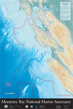 |
A
map of the Monterey Bay National Marine Sanctuary, featuring bathymetric and topographical information. The spectacular image is ideal for education purposes, map lovers and anyone that appreciates beautiful art.
The graphic below is provided for your personal and educational use.
Map
Image (650 x 929; 179KB jpeg)
Contact The Monterey Bay Sanctuary Foundation to purchase this poster. |
| TOP |
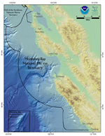 |
MBNMS Map - Color
MBNMS color map including bathymetry and hillshade.
Map Image (650 x 841; 228KB jpeg) |
| TOP |
 |
MBNMS Map - Black & White
MBNMS black and white map of the Sanctuary and county boundaries.
Map Image (650 x 841; 188KB jpeg) |
| TOP |
 |
Critical Coastal Areas Map
The Critical Coastal Areas (CCA) Program fosters collaboration among local stakeholders and government agencies, to better coordinate resources and focus efforts on coastal watersheds in critical need of protection from polluted runoff. Please visit the following web page for more information.
Map Image (650 x 841; 216KB jpeg) |
| TOP |
 |
NOAA's Northern and Central California Biogeographic Assessment
Access over one hundred maps showing densities and common locations of many animals, from seabirds to blue whales
*this does not include Davidson Seamount Management Zone (DSMZ) since the assessment was done prior to DSMZ incorporation* |
| TOP |
 |
SIMoN Interactive Map
Three differently-themed interactive maps. Customize and print your own map |
| TOP |
 |
Overflight Map
GIS map illustrating the four zones with overflight restrictions. Please visit the following web page for more information.
Map Image (650 x 841; 140KB jpeg) |
| TOP |
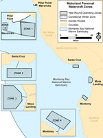 |
Motorized Personal Watercraft Use Map
Motorized Personal Watercraft use zones. Map showing the four designated zones and access routes within the Sanctuary, with overlay of pinniped haul-out and seabird nesting areas. Please visit the following web page for more information.
Map Image (600 x 805; 160KB jpg) |
| TOP |
 |
Motorized Personal Watercraft Use Map - Zone 5
Map Image (883 x 650; 220KB jpeg) |
| TOP |
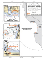 |
Dredging Map
Dredging sites for the four harbors in the MBNMS including Pillar Point, Moss Landing, Santa Cruz and Monterey harbors. Please visit the following web page for more information.
Map Image (600 x 744; 180KB jpg) |
| TOP |
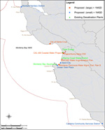 |
Desalination Map
Existing and potential desalination plants in the Monterey Bay National Marine Sanctuary. Please visit the following web page for more information.
Map Image (600 x 744; 172KB png) |
| TOP |
 |
Elkhorn Slough Map
The main channels of the Elkhorn Slough fall under the Monterey Bay National Marine Sanctuary jurisdiction. The surrounding marsh areas are under the Elkhorn Slough National Estuarine Research Reserve jurisdiction.
Map Image (600 x 792; 188KB jpg) |
| TOP |
 |
Davidson Seamount Managment Zone
Taking, disturbing, injuring, or possessing any sanctuary resource, the source of which is more than 3,000 feet below the sea surface within the Davidson Seamount Management Zone, is prohibited.
Map
Image (600 x 776; 200KB
jpg) |
| TOP |
 |
Watersheds in the MBNMS Region
The Monterey Bay National Marine Sanctuary receives runoff from watersheds that cover an extensive area. Please visit the following web page for more information.
Map
Image (650 x 841; 208KB
jpg) |
| TOP |
 |
Recommended
Vessel Tracks
Effective and safe vessel traffic management within the Monterey Bay National Marine Sanctuary is ensured by vessels following these tracks. Please visit the following web page for more information.
Map
Image (650 x 841; 196KB
jpg) |
| TOP |
 |
MPA and ASBS Sites in the MBNMS
Areas of Special Biological Significance are a subset of state water quality protection areas that protect resources from an undesirable alteration in natural water quality. Please visit the following web page for more information.
Map
Image (650 x 841; 208KB
jpg) |
| TOP |
 |
Marine Protected Areas in the MBNMS
The Marine Life Protection Act (MLPA) directs the state to reevaluate and redesign California’s system of marine protected areas (MPAs). This map portrays both the Central Coast MPAs (implemented in 2007) and the North Central Coast MPAs (implemented in 2009) within the MBNMS.
For more information about the MLPA effort, click here.
For more information about MPAs in the
MBNMS, click here.
Map
Image (650 x 841; 208KB
jpg) |
| TOP |
 |
Marine Protected Areas and Trawling Closures in the MBNMS
Groundfish closed areas specific to particular gear types transect the Monterey Bay National Marine Sanctuary. Please visit the following web page for more information.
Map Image (650 x 841; 284KB jpg) |


