KEO
Kuroshio Extension Observatory (32.3°N, 144.5°E)
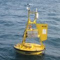
The NOAA Kuroshio Extension Observatory (KEO) moored buoy is located in the recirculation gyre south of the Kuroshio Extension at 32.4°N, 144.6°E . It is an Ocean Climate Station (OCS) mooring that is part of the global network of OceanSITES time series reference sites. KEO's first deployment was in June 2004. The mooring carries a suite of meteorological sensors to measure winds, air temperature, relative humidity, rainfall, and solar and longwave radiation; subsurface sensors to monitor upper ocean temperature, salinity, and currents; as well as the MAPCO2 sensor.
For more information about the mooring and meteorological sensors please visit the PMEL OCS KEO Website.
Finalized Data availability: submitted to Carbon Dioxide Information Analysis Center (CDIAC).
Plots of surface water and atmospheric CO2:


| Data are unverified | |
 |
|
 |
|


