

NSSL's NOXP mobile radar waits to be shipped to France to participate in the HyMeX experiment.

NSSL researchers work on one of the Oklahoma Lightning Mapping Array sites. OKLMA will be used in the DC3 field experiment.

NSSL researchers are working with the Salt River Project to verify microburst and haboob algorithms.

NSSL's Dave Jorgensen worked in the NOAA P-3 aircraft during Project DYNAMO.

NSSL's Scott Giangrande provides nowcasting support for aircraft operations during the MC3E experiment.
Swarms of bats appear as “blooms” on dual-pol mobile radar display.

NSSL provided nowcasting support during the Vancouver 2010 Winter Olympics and Paralympics.
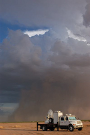
NSSL's mobile radars have been employed to collect data to better understand flash flooding during monsoon season in the southwestern U.S.

VORTEX2 was the largest tornado research project in history.

NSSL's mobile radar was used to help develop improved warnings for mudlsides in areas of California recently burned by wildfires.
The TELEX project investigated how lighting and other electrical storm properties are dependent on storm structure, updrafts, and precipitation.

The IPEX project studied winter weather across northern Utah to develop a better understanding of the structure and evolution of winter storms.

The TOtable TOrnado Observatory (TOTO) was a 55 gallon barrel outfitted with anemometers, pressure sensors, and humidity sensors, along with devices to record data. Several groups tried to deploy TOTO in the path of a tornado over the years, but never scored a direct hit.

Aircraft flew into thunderstorms to measure turbulence during Project Rough Rider in the 1960s, '70s and early '80s. This research led to improved commercial airline safety guidelines in the vicinity of thunderstorms that are still in use today.
Field Projects: Present and past
NSSL participates in field research projects to collect weather data that will increase our knowledge about thunderstorm behavior and thunderstorm hazards.
HyMeX (2012)
The Hydrological cycle in the Mediterranean EXperiment investigated the hydrological cycle in the Mediterranean, with emphasis on the predictability and evolution of extreme weather events.
DC3 (2012)
The Deep Convective Clouds and Chemistry field experiment investigated thunderstorms using aircraft and ground-based instruments. The project will help us understand how thunderstorm updrafts carry electrically charged particles, water vapor and other chemicals to other parts of the atmosphere.
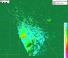
Microburst and haboob prediction algorithm verification (2012)
In a ten-year cooperative research venture with the Salt River Project (SRP), an Arizona power and water utility, NSSL operates NOXP during the monsoon season near Phoenix, Ariz. to verify microburst and haboob prediction algorithms.
DYNAMO (2011)
An NSSL researcher deployed to the Indian Ocean to be Chief Scientist for convective storm studies using the NOAA P-3 research aircraft in the Dynamics of the Madden-Julian Oscillation experiment. The results of DYNAMO will help researchers better understand and forecast the weather and climate of the equatorial Indian Ocean and around the world.
MC3E (2011)
An NSSL scientist joined forces with the Department of Energy and NASA in the Mid-latitude Continental Convective Clouds Experiment to use more than 50 instruments to collect 3D data on the lifecycles of severe storms, as well as detailed measurements of the environment in which the storm occurs. These data will provide new details about convective cloud processes for computer models to accurately reproduce the formation, growth and decay of clouds and precipitation associated with storm systems.
Detecting bats (2011)
Several mobile radars, including NSSL's dual-polarized mobile radar were used in a project to track swarms of millions of bats as they emerged from their caves each night to feast on insects. The radar images of bats appear as distinct “blooms.” NSSL used the data to enhance radar algorithms that remove the bioscatter clutter to see the weather more clearly.
NSSL Briefings: NSSL uses weather radar clutter to help biologists
SNOW V-10 (2010)
NSSL researchers operated the mobile Doppler radar as part of the Science and NOWcasting of Olympic Weather for Vancouver 2010. The team supported the Cypress Mountain Venue during the Olympic and Paralympic Winter Games in Vancouver, British Columbia.
SWCO (2010)
NSSL deployed a mobile radar in the Southwest Colorado Radar Project to collect data on thunderstorm rainfall to better understand and forecast flash flooding caused by the Southwest Monsoon.
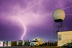
VORTEX2 (2009-2010)
NSSL participated in the Verification of the Origins of Rotation in Tornadoes EXperiment 2009-2010, the largest tornado research project in history to explore how, when and why tornadoes form. The National Oceanic and Atmospheric Administration (NOAA) and National Science Foundation (NSF) supported more than 100 scientists, students and staff from around the world to collect weather measurements around and under thunderstorms that could produce tornadoes.
PUFFS (2008)
NSSL, in collaboration with the Salt River Project and the Phoenix National Weather Service Office, conducted the Phoenix Urban Flash Flood Study in Phoenix, AZ during the 2008 North American Monsoon. PUFFS used the Shared Mobile Atmospheric Research and Teaching Radar (SMART-R) in Arizona to observe the lifecycle of strong microbursts and assess their impact on the Salt River Project's electrical power transmission and infrastructure.
DARE (2007)
The Data Assimilation Resolution Experiment collected data on the vertical structure of multi-cell storms.
PASSE (2007)
The Phased-array SMART-R Spring Experiment collected data on supercell storms at low altitudes to improve storm-scale forecasts and to verify Phased Array Radar data.
USGS Debris Flow Early Warning System Demonstration Project (2005-2009)
California benefitted from NSSL's mobile radar used to improve warnings of mudslides in areas recently burned by wildfires.
USGS Debris Flow Project website
North American Monsoon Experiment (2004)
Scientists from more than 30 universities, laboratories and agencies in the U.S., Mexico and Central America participated in a large study of midsummer rains (monsoon) that affect farming, ranching, wildfire control, water resource management and public safety throughout the southwestern U.S.
TELEX (2003-2004)
The Thunderstorm Electrification and Lightning EXperiment investigated how lighting and other electrical storm properties are dependent on storm structure, updrafts, and precipitation.
BAMEX (2003)
The Bow Echo and MCV Experiment was a field experiment to understand and improve prediction of mesoscale and storm-scale processes that produce severe winds in bowing convective systems lasting at least four hours.
PACJET (2002-2003)
NSSL participated in the Pacific Land falling Jets Experiment along and offshore of the U.S. Pacific coastline to improve short-term forecasts and warnings of floods, damaging winds and other severe weather.
SALLJEX (2002-2003)
The South American Low Level Jet Experiment (SALLJEX) was a field experiment carried out in western-central South America during the 2002-2003 rainy season as part of the South American low-level jet (SALLJ) program.
NSSL's SALLJEX page :: SALLJEX website
J-POLE (2002)
The Joint Polarization Experiment tested the capabilities of NSSL's experimental polarized Doppler radar. Intercept vehicles verified precipitation in the field and a T-28 research aircraft collected cloud microphysics data to help assess radar data and product quality.
IHOP (2002)
NSSL partnered with researchers from around the world for the International H20 field project. The goal was to investigate the process of convective initiation and boundary evolution, and learn what types of data are needed to make forecasts of thunderstorms and rainfall amounts more specific.
IPEX (2000)
The Intermountain Precipitation Experiment studied winter weather across northern Utah to develop a better understanding of the structure and evolution of winter storms.
STEPS (2000)
The Severe Thunderstorm Electrification and Precipitation Study made meteorological and electrical observations of supercell thunderstorms on the high plains.
MAP (1999)
NSSL scientists directed research aircraft in Europe's Mesoscale Alpine Project. MAP studied the effects of winds and precipitation over mountainous terrain.
VORTEX-99 (1999)
NSSL and OU conducted VORTEX-99, a small follow-on project to the original VORTEX. VORTEX-99 was operating when an F5 tornado tore through parts of south Oklahoma City on May 3, 1999.
SubVORTEX (1998)
NSSL conducted the SubVORTEX project as an extension of VORTEX with fewer vehicles and a tighter focus.
MEaPRS (1998)
The MCS Electrification and Polarimetric Radar Study was designed to investigate polarization radar signatures and electrification in mesoscale convective systems occurring over the Oklahoma-Texas-Kansas region.
PACS-SONET (1997)
The Pan American Climate Studies Sounding Network project was designed to collect low-cost upper atmospheric data from Central and South America. Pilot balloon observations, used at first to reanalyze the quality of the windfields over the area, are now available in a real-time data collection and distribution network for climate research activities and experiments.
Pan-American Clmate Studies website
FASTEX (1997)
Shannon, Ireland, was the base of field operations for the Fronts and Atlantic Storm Tracks Experiment. During FASTEX, observations were made using seven research aircraft and four research ships to document life cycles of cyclones originating over the data-sparse North Atlantic.
SubVORTEX (1997)
NSSL conducts the SubVORTEX project as an extension of VORTEX with fewer vehicles and a tighter focus.
SWAMP (1995-1999)
Southwest Area Monsoon Project. Investigation of lightning and terrain in the Four Corners region (AZ, CO, NM, UT).
VORTEX (1994-1995)
The Verification of the Origins of Rotation in Tornadoes EXperiment was a two-year project designed to answer a number of ongoing questions about the causes of tornado formation. A new mobile Doppler radar was used and provided revolutionary data on several tornadic storms.
SWAMP (1993) SouthWest Area Monsoon Project
SWAMP investigated central Arizona thunderstorm environments, monsoon structures and moisture fluxes, and Mexican convective systems.
TOGA-COARE (1992-1993)
An NSSL researcher used Doppler-equipped aircraft observe western Pacific Mesoscale Convective Systems in the Tropical Ocean Global Atmosphere (TOGA) Coupled Ocean Atmosphere Response Experiment (COARE).
STORM-FEST (1992)
Investigated structure and evolution of fronts associated with mesoscale phenomena in the central U.S. with emphasis on precipitation and severe weather.
STORMTIPE (1992)
Verification of a 3D cloud-scale model used in operational forecasting environment to forecast storm type.
COPS-91 (1991)
NSSL participates in the Cooperative Oklahoma Profiler Studies of 1991 and uses instrumented aircraft and a ground-based network of instruments to sample tornadic supercells.
GUFMEX (1988) GUlf of Mexico EXperiment
Collecting data on air masses and moisture flows over the southern shores of the U.S.
TAMEX (1987) Taiwan Area MEsoscale EXperiment
Three Doppler radars complemented enhanced surface and upper-air observations in Taiwan to better understand how terrain interacts with precipitation systems to produce heavy rainfall.
DOPLIGHT (1987)
The DOPpler radar and LIGHTning was a joint NSSL/Oklahoma City Field project evaluating and verifying real-time Doppler radar data and forecasts.
NEXRAD IOT&E I and II (1987-1988)
NEXRAD Initial Operational Testing and Evaluation.
COHMEX (1986)
COoperative Huntsville Meteorological EXperiment
PRE-STORM (1985)
Preliminary Regional Experiment for STORM-Central. Data collection and forecasting for Mesoscale Convective Systems.
TOTO (1981-1984)
The TOtable TOrnado Observatory (TOTO), developed by NOAA Environmental Research Laboratory scientists, was a 55 gallon barrel outfitted with anemometers, pressure sensors, and humidity sensors, along with devices to record the data. In theory, a team would roll TOTO out of the back of the pickup in the path of a tornado, switch on the instruments, and get out of the way. Several groups tried to deploy TOTO over the years, but never scored a direct hit. The closest TOTO ever came to success was in 1984 when it was sideswiped by the edge of a weak tornado and was knocked over. TOTO was retired in 1984.
SESAME (1979)
The Severe Environmental Storm and Mesoscale Experiment sampled Southern Plains storm activity at different scales of motion.
JDOP (1977-1978)
NSSL conducted the Joint Doppler Operational Project to prove Doppler radar could improve the nation's ability to warn for severe thunderstorms and tornadoes. This led to the decision in 1979 by the National Weather Service (NWS), U.S. Air Force's Air Weather Service, and Federal Aviation Administration (FAA) to include Doppler capability in their future operational radars.
Project Rough Rider (1980s)
Aircraft flew into thunderstorms to measure turbulence during in the 1960s, 1970s and early 1980s. This data was combined with measurements of the intensity of the rain from the WSR-57 to understand how thunderstorm echoes and turbulence are related. This research led to improved commercial airline safety guidelines in the vicinity of thunderstorms that are still in use today.
TIP (1975-1986)
NSSL's legacy in organized field experiments begins with the Tornado Intercept Project led by NSSL's Bob Davies-Jones. NSSL's Don Burgess provided storm intercept crews with live radar information via radio—and the term, “nowcaster,” was born.