
- Panama City Lab Home
- About the Panama City Lab
- Library
- Education and Outreach
- Fisheries Biology
- Reef Fish Survey
- Marine Protected
- Observer Programs
- Protected Species
- Sharks
MPA Projects
NOAA Fisheries Panama City Laboratory has conducted research on the efficacy of Marine Protected Areas (MPAs) as a fishery management tool since 2001. This work has focused in five areas; three MPAs in the northeastern Gulf of Mexico along the West Florida shelf, five proposed MPAs in the South Atlantic Bight between southern North Carolina and northern Florida, the Oculina Habitat Area of Particular Concern (OHAPC) east of the Florida coast, the Pulley Ridge HAPC northwest of the Dry Tortugas in Florida, and deep-sea coral HAPCs in the South Atlantic Bight between southern North Carolina and southern Florida. The fishing regulations in all these areas are designed to protect and enhance populations of economically valuable reef fish, primarily gag grouper (Mycteroperca microlepis) in the Gulf of Mexico and seven species of grouper and tilefish in the South Atlantic. These species are considered to be at risk due to current stock levels and life history characteristics which make them vulnerable to overfishing. All of these fishes are slow growing, long-lived species, and several are overfished or are undergoing overfishing based on recent stock assessments. Additionally, the grouper are protogynous hermaphrodites with haremic spawning focused on high-relief hardbottom sites which are easily targeted by fishing operations. The current percentage of males is low by historical standards and can be further reduced by fishing on these aggregation sites during the spawning season when aggressive male behavior results in selective removal. Research in all areas is ongoing, although the MPA surveys are in different stages of the evaluation process. The West Florida Shelf study began in 2001, several months after the fishing restrictions were implemented and data has been collected annually since then. Efficacy tests are based on comparisons of the MPAs with adjacent open-to-fishing areas containing similar habitat. Fishing restrictions in the South Atlantic Bight MPA sites were recently implemented in February 2009, but we have been studying these areas annually since 2004. Thus, our survey presents a unique opportunity to examine the same locations pre and post-closure. Four surveys have taken place in the proposed South Atlantic Bight MPAs and will be compared to all data collected post-closure (starting in 2009) to determine efficacy.
Methodology used
Similar methodologies are followed in all areas, estimates are made of species abundance and distribution along with habitat associations based on stationary remote camera and remote operated vehicle (ROV) video data.
The equipment used for our projects:
- Remotely operated vehicle (ROV). The ROV provides continuous video data as well as high resolution digital still images of fish and habitat within the study areas. The video footage is used to delineate and quantify habitat types as well as fish species presence and density within each habitat type. A ROV tracking system allows georeferencing of fish and habitat data.
- Stationary Video Camera Array. This array utilizes four orthogonally spaced digital video cameras to determine relative abundance of fishes and percent cover of habitat. The array has no lights, does not move, and emits no sounds and therefore provides more accurate data on fishes than the ROV because it does not modify their behavior as much. However, data collected from the array is far more restricted geographically due to its static positioning.
- Chevron fish trap. A limited number of fish are collected to determine age and size structure of local populations as well as determine spawning condition. All fish collected are measured, weighed and have otoliths and gonads removed for age, growth and reproductive studies.
- Hydrographic data. Two CTDs are routinely employed on these surveys. A SeaBird SB-19+ provides full water column measurements of depth, salinity, temperature, dissolved oxygen and light transmissivity at each station. A smaller Seabird SBE-39 is mounted on the ROV for temperature and depth determinations along ROV transects.
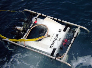
Remotely Operated Vehicle (ROV)
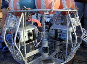
Stationary Camera Array
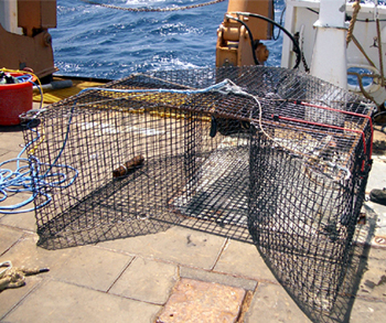
Chevron Fish Trap

Conductivity Transmissivity Temperature
Mapping and GIS
Ideally, the assessment of the efficacy of MPAs requires a sequential approach of mapping, habitat delineation and fishery surveys. High resolution maps are crucial in stratification and site selection for this type of study. However, maps are not always available before cruises are planned. This was the case in the South Atlantic Bight MPA 2004 cruise, where site selection was based upon local knowledge and split beam bathymetry collected during the cruise. Limited multibeam bathymetry and backscatter data has been collected subsequently (35% of Northern South Carolina and 10% of Georgia), however full coverage of the areas does not exist. The West Florida Shelf MPAs were mapped in 2001 and 2002 with complete bathymetric and backscatter coverage of both MPAs and the control area. Additional areas along the West Florida Shelf have been mapped since then. In the Oculina HAPC, multibeam mapping has been completed in collaboration with the NURC center in the University of North Carolina, in Wilmington. For the Pulley Ridge area, mapping is not yet completed, only having mapped the southern part of the HAPC and parts of the northern area.
Multibeam bathymetric and backscatter maps along with all fishery and habitat data are included in a GIS project currently underway. Seabed classification is also underway incorporating existing bathymetry, backscatter and visual groundtruthing data with QTC Multiview software (Quester Tangent). The integration and spatial analysis of this data will be performed with ArcGIS (ESRI). Mapping of the MPA sites is extremely important for several reasons. Complete maps allow the management councils to more precisely select areas to be included in MPAs and they allow more statistically robust surveys to be designed. Securing funds to complete the mapping of the South Atlantic Bight proposed MPA sites and Pulley Ridge remains a high priority.
How Do I...?
- Distinguish a white marlin from a spearfish
- How do I report a stranded/ beached whale, dolphin, or turtle?
- How do I report a lionfish sighting?
- Access SouthEast Data, Assessment, and Review (SEDAR)
- How do I report for my fishing/dealer permit requirements?
- How do I report a retrieved tag?
- How do I find current fishery closures?
- How do I adopt a billfish?
- How do I register my billfish tournament?
- How do I apply for a permit?
- Visit the SEFSC library
- How do I find NOAA staff?
- How do I apply for grant funding?
- How do I request permission to use a photo found on the website?
- How do I find It? Provide Website Feedback
