National Weather Service
New Orleans/Baton Rouge
Deepwater Horizon Decision Support Page

PLAQUEMINES PARISH SUPPLEMENTAL FORECASTS

Pass Abel Hourly Forecast
South Pass Hourly Forecast
Breton Island North Point Hourly Forecast
Breton Sound Marine Forecast
Boothville to SW Pass Marine Forecast

Click here to access water temperature data from the LSU WAVCIS site in Breton Sound

TOP GRAPHICS

NASA MODIS Image
Latest NASA MODIS Imagery
OPC Currents
Ocean Prediction Center Currents
EMC/RTOFS Currents
EMC Marine Modeling/RTOFS Model
Deepwater Graphic
Latest Deepwater Graphic

 TROPICAL WEATHER

Tropical Outlook
Tropical Weather Outlook
Satellite Views
Tropical Satellite Views
Tropical Discussion
Tropical Weather Discussion
AOML AnalysesGOM Sea Surface Temperatures

National Hurricane Center Main Page
Forecast Model Guidance*

* Forecasts generated by various computer models are unofficial.  For the official forecast please refer to the National Hurricane Center. *

 GRAPHICS FROM NOAA nowCOAST

Currents
Currents
Radar/Observations
Radar Mosaic, Surface Observations and Short Fused Warnings
SSTs/Wave Heights
Sea Surface Temperatures and Mean Wave Heights

RADAR SITES

Lake Charles
Local Radar for Lake Charles
                        - Click to enlarge
Slidell
Local Radar for New Orleans/Baton Rouge - Click to enlarge
Mobile
Local Radar for
                        Mobile/Pensacola - Click to enlarge
Tallahassee
Local Radar for Tallahassee -
                        Click to enlarge

FORECASTS/METEOGRAMS

Select a location on the map below for the current forecast for that location. There are land based weather forecasts, tidal forecasts, TAF forecasts (terminal forecasts) and marine forecasts to select from. We now have these on a new Google maps based background. Please let us know using the e-mail address at the bottom of the page if you have any problems. In addition, you may still select your desired location from the drop down box located below the legend.

NOTE: You can zoom into a location you are interested in to see more choices for that area.


LEGEND

Tide Station Locations
Buoy Locations
METAR Locations
Shoreline Meteograms
Latitude/Longitude Disclaimer: The locations shown in the above map are the approximate locations based on the latitude/longitude coordinates provided to the NWS. Some of the locations have been altered slightly to allow for better viewing on the standard map.

OFFSHORE FORECASTS FROM TAFB/NHC

Sea State Analysis
Sea State Analysis

GOM SFC Analysis
GOM Surface Analysis

24 HR Wind/Wave
24HR Wind/Wave

48HR Wind/Wave
48HR Wind/Wave

72HR Wind/Wave
72HR Wind/Wave

TAFB Main Page
Offshore Text Forecast

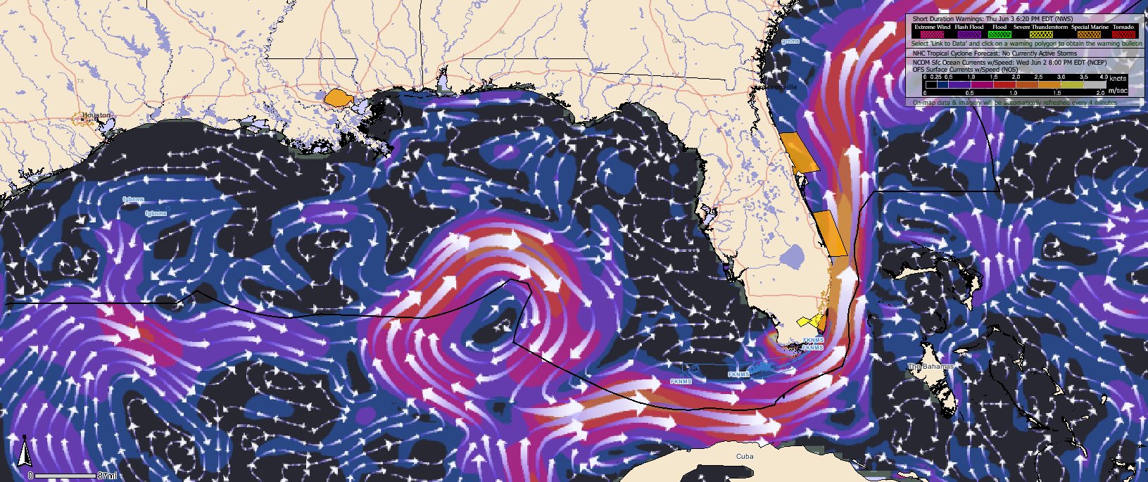
WIND/WAVE FORECAST/ANALYSIS GRAPHICS

NOTE: In order to speed the loading of this page, these graphics have been moved to a new page.

If you would like to see the graphics, please visit: Deepwater Wind/Wave Graphics

OTHER LINKS

 NWS Mobile Deepwater Horizon Decision Support Page

Louisiana Emergency Management Website

Mississippi Emergency Management Website

 Latest NOAA Situational Report (includes trajectories)

NOAA's Oil Spill Response: Hurricanes and the Oil Spill

 NOAA Fisheries Service Page

 HYSPLIT Smoke Plume Trajectories Graphic

Tides at a Glance (all tidal locations on map above)

NWS Mesonet Current Observations

LSU WAVCIS Page

OTHER INFORMATION

  • To contact the NWS Forecast Office in Slidell for additional weather information, please call: 504-522-7330 or 985-649-0357 and press 4.
  • For NOAA media inquiries, please contact Keely Belva. You can e-mail her at keeley.belva@noaa.gov or by calling 301-713-3066.
  • For response inquiries, please phone the Joint Information Center (JIC) at 985-902-5231 or 985-902-5240.
  • To report oil on land, or for general Community and Volunteer Information, please call 866-448-5816.
  • To report oiled or injured wildlife, please call 866-557-1401.
  • To discuss spill related damage claims, please call 800-440-0858.
  • BP is asking fishermen for their assistance in cleaning up the oil spill. BP is calling this the Vessel of Opportunities Program and through it, BP is looking to contract shrimp boats, oyster boats and other vessels for hire to deploy boom in the Gulf of Mexico. Fishermen should phone 281-366-5511 about this program.

If you have any comments, questions or requests for this page please e-mail Shawn O'Neil at shawn.oneil@noaa.gov.


USA.gov is the U.S. government's official web portal to all federal, state and local government web resources and services.