USGS - science for a changing world

Minnesota Water Science Center

  Home   Information/Data   Projects   Publications   Drought   Flood   NAWQA   Office   Contact   Other USGS

Minnesota PROJECTS

ABOUT THE MINNESOTA
WSC

USGS IN YOUR STATE

USGS Water Science Centers are located in each state.

There is a USGS Water Science Center office in each State. Washington Oregon California Idaho Nevada Montana Wyoming Utah Colorado Arizona New Mexico North Dakota South Dakota Nebraska Kansas Oklahoma Texas Minnesota Iowa Missouri Arkansas Louisiana Wisconsin Illinois Mississippi Michigan Indiana Ohio Kentucky Tennessee Alabama Pennsylvania West Virginia Georgia Florida Caribbean Alaska Hawaii New York Vermont New Hampshire Maine Massachusetts South Carolina North Carolina Rhode Island Virginia Connecticut New Jersey Maryland-Delaware-D.C.

Project Title: Characterizing Groundwater and Surface-Water Interactions in White Bear Lake, Minnesota
Project Number: NQ00EHR - MN275
Project Chief: Perry Jones
Project Start Date: March 2011
Project End Date: September 2012
Cooperators: White Bear Lake Conservation District (WBLCD) and Minnesota Pollution Control Agency (MPCA)


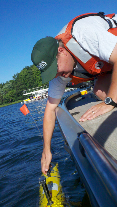
Objective: Characterize groundwater and surface-water interactions in White Bear Lake and the response of lake water levels to changes in precipitation and groundwater flow conditions.

Progress During FY11: Meetings were conducted with potential cooperators to outline the study. A draft proposal was written and presented to potential cooperators. Final agreements were signed between the USGS and the White Bear Lake Conservation District and Minnesota Pollution Control Agency. Researchers from the University of Minnesota collected lake sediment cores to determine the thicknesses of low-permeable organic sediments. Two groundwater-level synoptic studies were completed. Water-levels were measured in municipal, domestic, monitoring, and commercial wells screened or opened to glacial or bedrock (St. Peter Sandstone and Prairie du Chine Group) aquifers. USGS hydrologists conducted a water-quality mapping survey of White Bear Lake using a water-quality autonomous underwater vehicle to assess groundwater and surface water interactions. Lake sediment temperature surveys were conducted along the lake shores. Water sasmples, including lake water, groundwater, lake-sediment-pore water, and rain water samples, were collected for isotope and other water-quality analyses to assess the water balance of White Bear Lake. Groundwater flow rates into and out of White Bear Lake were measured along the lake shore. Seepage meters and minipiezometers were used to measure flow rates and groundwater levels, respectively, in lake shore sediments. Large groundwater inflow rates to the lake were found at along the east and south shores of White Bear Lake. USGS hydrologists conducted a water-quality survey of White Bear Lake using autonomous underwater vehicle with a multi-parameter probes. The survey was done to identify potential areas of groundwater inflow to the lake.

Statement of Work for FY12: Prepare hydrologic and water-quality data into the USGS data bases. Analysis of data will be completed and a draft final report for the project will be prepared and published.

In the news

USGS Home Water Climate Change Core Science Ecosystems Energy&Env. Health Hazards

Accessibility FOIA Privacy Policies and Notices

Take Pride in America logo USA.gov logo U.S. Department of the Interior | U.S. Geological Survey
URL: http://mn.water.usgs.gov/projects/description/NQ00EHR00.html
Page Contact Information: Webmaster
Page Last Modified: Thursday, 29-Nov-2012 09:56:31 EST

05388250: Flow=358cfs,Stage=7.56ft,Floodstage=14ft,2013-02-16 08:00,76-90,Upper Iowa River near Dorchester, IA 05320000: Flow=25cfs,Stage=1.13ft,2013-02-16 08:00,10-24,BLUE EARTH RIVER NEAR RAPIDAN, MN 05129115: Flow=141cfs,Stage=4.84ft,2013-02-16 08:30,10-24,VERMILION RIVER NR CRANE LAKE, MN 05127500: Flow=431cfs,Stage=2.70ft,2013-02-16 08:30,10-24,BASSWOOD RIVER NEAR WINTON, MN 05340500: Flow=1760cfs,Stage=2.70ft,2013-02-16 07:15,25-75,ST. CROIX RIVER AT ST. CROIX FALLS, WI 05338500: Flow=79cfs,Stage=2.84ft,Floodstage=9ft,2013-02-16 08:15,25-75,SNAKE RIVER NEAR PINE CITY, MN 05278000: Flow=10cfs,Stage=2.43ft,2013-02-16 08:00,25-75,MIDDLE FORK CROW RIVER NEAR SPICER, MN 05247500: Flow=570cfs,Stage=3.43ft,2013-02-16 08:30,25-75,CROW WING RIVER NEAR PILLAGER, MN 05124480: Flow=54cfs,Stage=3.03ft,2013-02-16 08:15,25-75,KAWISHIWI RIVER NEAR ELY, MN 05046000: Flow=268cfs,Stage=2.71ft,2013-02-16 08:30,25-75,OTTER TAIL RIVER BL ORWELL D NR FERGUS FALLS, MN 464646092052900: Stage=600.60ft,2013-02-16 07:00:00,Not ranked,Rating being developed or revised,SUPERIOR BAY DULUTH SHIP CANAL AT DULUTH, MN 06604000: Stage=12.75ft,Floodstage=17ft,2013-02-16 08:15,Not ranked,Spirit Lake near Orleans, IA 06483290: Flow=71cfs,Stage=7.29ft,Floodstage=13ft,2013-02-16 08:15,Not ranked,Rock River below Tom Creek at Rock Rapids, IA 06482610: Not ranked,Ice affected,SPLIT ROCK CR AT CORSON,SD 05476000: Stage=3.54ft,2013-02-16 08:00:00,Floodstage=12ft,Not ranked,Ice affected,DES MOINES RIVER AT JACKSON, MN 05475350: Stage=10.90ft,Floodstage=19ft,2013-02-16 08:00,Not ranked,DES MOINES RIVER ABOVE WINDOM, MN 05457000: Stage=2.68ft,2013-02-16 08:00:00,Not ranked,Ice affected,CEDAR RIVER NEAR AUSTIN, MN 05386400: Stage=31.13ft,2013-02-16 08:45,Not ranked,MISSISSIPPI RIVER AT BROWNSVILLE, MN 05385500: 2013-02-16 08:45,Not ranked,SOUTH FORK ROOT RIVER NEAR HOUSTON, MN 05385000: Stage=3.99ft,Floodstage=15ft,2013-02-16 08:45,Not ranked,ROOT RIVER NEAR HOUSTON, MN 05383950: Stage=8.52ft,2013-02-16 09:00:00,Not ranked,Ice affected,ROOT RIVER NEAR PILOT MOUND, MN 05383075: Stage=2.72ft,2013-02-16 07:00:00,Not ranked,Ice affected,LA CROSSE RIVER NEAR LA CROSSE, WI 05378500: 2013-02-16 07:00,Stage=5.62ft,2013-02-16 08:45:00,Floodstage=13ft,Not ranked,Very low value,MISSISSIPPI RIVER AT WINONA, MN 05378490: Stage=5.75ft,2013-02-16 07:00,Not ranked,MISSISSIPPI RIVER AT LOCK AND DAM 5A NR WINONA, MN 05374900: Stage=4.06ft,2013-02-16 08:00,Not ranked,ZUMBRO RIVER AT KELLOGG, MN 05374000: Stage=5.27ft,Floodstage=18ft,2013-02-16 08:30,Not ranked,ZUMBRO RIVER AT ZUMBRO FALLS, MN 05372995: Stage=2.12ft,2013-02-16 08:15:00,Floodstage=14ft,Not ranked,Ice affected,SOUTH FORK ZUMBRO RIVER AT ROCHESTER, MN 05355200: Stage=3.51ft,2013-02-16 08:15:00,Not ranked,Ice affected,CANNON RIVER AT WELCH, MN 05355024: Stage=889.65ft,2013-02-16 08:30,Not ranked,CANNON RIVER AT NORTHFIELD MN 05353800: Stage=3.84ft,2013-02-16 08:15:00,Not ranked,Ice affected,STRAIGHT RIVER NEAR FARIBAULT, MN 05345000: Stage=2.78ft,2013-02-16 08:15:00,Not ranked,Ice affected,VERMILLION RIVER NEAR EMPIRE, MN 05344500: Stage=25.10ft,2013-02-16 08:00,Not ranked,Very low value,MISSISSIPPI RIVER AT PRESCOTT, WI 05344490: Stage=25.10ft,2013-02-16 08:15:00,Not ranked,Equipment malfunction,ST. CROIX RIVER AT PRESCOTT, WI 05342000: Flow=67cfs,Stage=10.41ft,2013-02-16 07:00,Not ranked,KINNICKINNIC RIVER NEAR RIVER FALLS, WI 05341550: Stage=675.42ft,2013-02-16 08:15:00,Floodstage=87ft,Not ranked,Equipment malfunction,ST. CROIX RIVER AT STILLWATER, MN 05336700: Stage=4.72ft,2013-02-16 08:45:00,Not ranked,Ice affected,KETTLE RIVER BELOW SANDSTONE, MN 05333500: Stage=2.31ft,2013-02-16 07:45:00,Floodstage=7ft,Not ranked,Ice affected,ST. CROIX RIVER NEAR DANBURY, WI 05331580: Stage=6.97ft,2013-02-16 08:30,Not ranked,MISSISSIPPI RIVER BELOW L&D #2 AT HASTINGS, MN 05331000: Stage=3.20ft,Floodstage=14ft,2013-02-16 08:15,Not ranked,Very low value,MISSISSIPPI RIVER AT ST. PAUL, MN 05330920: Flow=1030cfs,Stage=689.87ft,2013-02-16 07:45,Not ranked,MINNESOTA RIVER AT FORT SNELLING STATE PARK, MN 05330000: Stage=4.02ft,2013-02-16 08:45:00,Floodstage=25ft,Not ranked,Ice affected,MINNESOTA RIVER NEAR JORDAN, MN 05327000: Not ranked,Seasonal site,HIGH ISLAND CREEK NEAR HENDERSON, MN 05325000: Stage=1.19ft,2013-02-16 08:30:00,Floodstage=22ft,Not ranked,Ice affected,MINNESOTA RIVER AT MANKATO, MN 05320500: Stage=1.65ft,2013-02-16 08:00:00,Not ranked,Ice affected,LE SUEUR RIVER NEAR RAPIDAN, MN 05319500: Stage=0.59ft,2013-02-16 08:30:00,Not ranked,Ice affected,WATONWAN RIVER NEAR GARDEN CITY, MN 05317000: Stage=2.19ft,2013-02-16 08:00:00,Floodstage=11ft,Not ranked,Ice affected,COTTONWOOD RIVER NEAR NEW ULM, MN 05316580: Stage=7.25ft,2013-02-16 08:30:00,Not ranked,Ice affected,MINNESOTA RIVER AT MORTON, MN 05316500: Stage=1.66ft,2013-02-16 08:30:00,Floodstage=6ft,Not ranked,Ice affected,REDWOOD RIVER NEAR REDWOOD FALLS, MN 05315000: Stage=9.40ft,2013-02-16 08:45:00,Floodstage=14ft,Not ranked,Ice affected,REDWOOD RIVER NEAR MARSHALL, MN 05313500: Stage=2.70ft,2013-02-16 08:45:00,Not ranked,Rating being developed or revised,YELLOW MEDICINE RIVER NEAR GRANITE FALLS, MN 05311150: Stage=879.86ft,2013-02-16 08:15,Not ranked,MINNESOTA RIVER AT HWY 212 IN GRANITE FALLS, MN 05311000: Stage=2.54ft,2013-02-16 08:00:00,Floodstage=14ft,Not ranked,Ice affected,MINNESOTA RIVER AT MONTEVIDEO, MN 05305000: Stage=36.44ft,2013-02-16 08:00:00,Not ranked,Ice affected,CHIPPEWA RIVER (TW) NEAR WATSON, MN 05304995: 2013-02-16 08:00,Not ranked,CHIPPEWA R. (HW) ABOVE COUNTY RD 13 NR WATSON, MN 05304500: Stage=1.75ft,2013-02-16 08:30:00,Not ranked,Ice affected,CHIPPEWA RIVER NEAR MILAN, MN 05301000: Stage=20.48ft,2013-02-16 08:00:00,Not ranked,Ice affected,MINNESOTA RIVER NEAR LAC QUI PARLE, MN 05300000: Stage=5.54ft,2013-02-16 08:30:00,Not ranked,Rating being developed or revised,LAC QUI PARLE RIVER NEAR LAC QUI PARLE, MN 05294000: Stage=4.13ft,2013-02-16 08:45:00,Not ranked,Ice affected,POMME DE TERRE RIVER AT APPLETON, MN 05293000: Stage=2.39ft,2013-02-16 08:30:00,Not ranked,Ice affected,YELLOW BANK RIVER NEAR ODESSA, MN 05292000: Stage=1.25ft,2013-02-16 07:30:00,Floodstage=10ft,Not ranked,Ice affected,MINNESOTA RIVER AT ORTONVILLE, MN 05291000: Stage=2.03ft,2013-02-16 08:45:00,Floodstage=12ft,Not ranked,Ice affected,WHETSTONE RIVER NEAR BIG STONE CITY, SD 05290000: Stage=9.24ft,2013-02-16 08:45:00,Floodstage=17ft,Not ranked,Ice affected,LITTLE MINNESOTA RIVER NEAR PEEVER, SD 05289800: Stage=10.61ft,2013-02-16 09:00:00,Not ranked,Rating being developed or revised, Very low value,MINNEHAHA CREEK AT HIAWATHA AVE. IN MINNEAPOLIS,MN 05288705: Stage=10.11ft,2013-02-16 09:00:00,Not ranked,Ice affected,SHINGLE CREEK AT QUEEN AVE IN MINNEAPOLIS, MN 05288580: Stage=6.73ft,2013-02-16 08:45:00,Not ranked,Ice affected,RICE CREEK BLW OLD HWY. 8 IN MOUNDS VIEW, MN 05288500: Stage=1.86ft,2013-02-16 09:00:00,Not ranked,Ice affected,MISSISSIPPI RIVER NEAR ANOKA, MN 05287890: Stage=3.04ft,2013-02-16 08:30:00,Not ranked,Ice affected,ELM CREEK NR CHAMPLIN, MN 05286000: Stage=3.06ft,2013-02-16 08:15:00,Not ranked,Ice affected,RUM RIVER NEAR ST. FRANCIS, MN 05284000: Stage=10.54ft,2013-02-16 06:00,Not ranked,MILLE LACS LAKE AT COVE BAY NEAR ONAMIA, MN 05280000: Stage=1.87ft,2013-02-16 08:45:00,Floodstage=10ft,Not ranked,Ice affected,CROW RIVER AT ROCKFORD, MN 05275000: Stage=1.52ft,2013-02-16 08:15:00,Not ranked,Ice affected,ELK RIVER NEAR BIG LAKE, MN 05270700: Stage=4.61ft,2013-02-16 08:15:00,Floodstage=9ft,Not ranked,Ice affected,MISSISSIPPI RIVER AT ST. CLOUD, MN 05270500: Stage=2.03ft,2013-02-16 08:15:00,Floodstage=6ft,Not ranked,Ice affected,SAUK RIVER NEAR ST. CLOUD, MN 05267000: Stage=10.28ft,2013-02-16 08:15:00,Not ranked,Ice affected,MISSISSIPPI RIVER NEAR ROYALTON, MN 05245100: Stage=2.67ft,2013-02-16 08:15:00,Floodstage=6ft,Not ranked,Ice affected,LONG PRAIRIE RIVER AT LONG PRAIRIE, MN 05244000: Stage=3.93ft,2013-02-16 09:00:00,Not ranked,Ice affected,CROW WING RIVER AT NIMROD, MN 05243725: Stage=2.37ft,2013-02-16 08:30:00,Not ranked,Ice affected,STRAIGHT RIVER NEAR PARK RAPIDS, MN 05242300: Stage=5.92ft,2013-02-16 08:30:00,Floodstage=13ft,Not ranked,Ice affected,MISSISSIPPI RIVER AT BRAINERD, MN 05227500: Stage=6.48ft,2013-02-16 08:00:00,Floodstage=12ft,Not ranked,Ice affected,MISSISSIPPI RIVER AT AITKIN, MN 05212700: Stage=3.69ft,2013-02-16 08:45:00,Floodstage=10ft,Not ranked,Ice affected,PRAIRIE RIVER NEAR TACONITE, MN 05211000: Stage=4.88ft,2013-02-16 09:00:00,Not ranked,Ice affected,MISSISSIPPI RIVER AT GRAND RAPIDS, MN 05210000: Stage=73.29ft,2013-02-16 08:00,Not ranked,MISSISSIPPI R. AT DAYS HIGH LANDING NR DEER RIVER 05207600: Stage=7.67ft,2013-02-16 08:15:00,Not ranked,Ice affected,MISSISSIPPI RIVER AT WILLOW BEACH AT BALL CLUB, MN 05205900: Stage=94.26ft,2013-02-16 08:00,Not ranked,LEECH LAKE AT SUGAR POINT NEAR FEDERAL DAM, MN 05200510: Stage=3.22ft,2013-02-16 08:30:00,Not ranked,Seasonal site,MISSISSIPPI RIVER NEAR BEMIDJI, MN 05140521: 2013-02-16 08:00,Not ranked,LK OF THE WOODS @ SPRINGSTEEL IS NR. WARROAD, MN 05140520: Stage=58.35ft,2013-02-16 08:30,Not ranked,LAKE OF THE WOODS AT WARROAD, MN 05137500: Stage=4.04ft,2013-02-16 09:00:00,Not ranked,Rating being developed or revised,RAINY RIVER NEAR BOAT LANDING AT WHEELERS POINT,MN 05133500: Stage=5.55ft,2013-02-16 08:30:00,Not ranked,Ice affected,RAINY RIVER AT MANITOU RAPIDS, MN 05132000: Stage=3.87ft,2013-02-16 08:30:00,Not ranked,Ice affected,BIG FORK RIVER AT BIG FALLS, MN 05131500: Stage=2.53ft,2013-02-16 08:30:00,Not ranked,Ice affected,LITTLE FORK RIVER AT LITTLEFORK, MN 05129515: Not ranked,Ice affected,RAINY RIVER AT BOAT LANDING BLW INTERNATIONAL FLLS 05129290: Flow=69cfs,Stage=14.27ft,2013-02-16 08:30,Not ranked,GOLD PORTAGE OUTLET FROM KABETOGAMA LK NR RAY,MN 05126210: Flow=261cfs,Stage=3.89ft,2013-02-16 08:30,Not ranked,SOUTH KAWISHIWI R ABV WHITE IRON LAKE NR ELY, MN 05125000: Flow=99cfs,Stage=1.99ft,2013-02-16 08:30,Not ranked,SOUTH KAWISHIWI RIVER NEAR ELY, MN 05112000: Stage=2.06ft,2013-02-16 08:30:00,Not ranked,Ice affected,ROSEAU RIVER BELOW STATE DITCH 51 NR CARIBOU, MN 05107500: Stage=1.63ft,2013-02-16 08:30:00,Not ranked,Ice affected,ROSEAU RIVER AT ROSS, MN 05106000: Not ranked,Ice affected,SPRAGUE CREEK NEAR SPRAGUE, MANITOBA, CANADA 05104500: Stage=3.89ft,2013-02-16 08:30:00,Not ranked,Ice affected,ROSEAU RIVER BELOW SOUTH FORK NEAR MALUNG, MN 05102490: Stage=9.83ft,Floodstage=39ft,2013-02-16 08:30,Not ranked,RED RIVER OF THE NORTH AT PEMBINA, ND 05094000: Stage=3.29ft,2013-02-16 08:00:00,Floodstage=26ft,Not ranked,Ice affected,SOUTH BRANCH TWO RIVERS AT LAKE BRONSON, MN 05092000: Stage=11.03ft,2013-02-16 08:45:00,Floodstage=32ft,Not ranked,Ice affected,RED RIVER OF THE NORTH AT DRAYTON, ND 05087500: Stage=4.01ft,2013-02-16 09:00:00,Not ranked,Ice affected,MIDDLE RIVER AT ARGYLE, MN 05085450: Flow=0.15cfs,2012-07-11 23:45,Stage=58.35ft,2013-02-16 07:45:00,Floodstage=67ft,Not ranked,SNAKE RIVER ABOVE WARREN, MN 05083500: Stage=5.90ft,Floodstage=26ft,2013-02-16 08:15,Not ranked,RED RIVER OF THE NORTH AT OSLO, MN 05082500: Stage=15.34ft,2013-02-16 08:45:00,Floodstage=28ft,Not ranked,Ice affected,RED RIVER OF THE NORTH AT GRAND FORKS, ND 05080000: Not ranked,Ice affected,RED LAKE RIVER AT FISHER, MN 05079250: Flow=0.06cfs,Stage=0.31ft,2012-07-03 17:30,Not ranked,COUNTY DITCH 65 NEAR MAPLE BAY, MN (SW2) 05079200: Stage=0.91ft,2013-02-16 05:15:00,Not ranked,Ice affected,COUNTY DITCH 72 (BURNHAM CK) NR. MAPLE BAY  (SW3) 05079000: Stage=4.17ft,2013-02-16 08:45:00,Floodstage=15ft,Not ranked,Ice affected,RED LAKE RIVER AT CROOKSTON, MN 05078770: Flow=0.10cfs,2012-12-03 19:45,Stage=0.81ft,2012-12-11 15:00:00,Not ranked,JUDICIAL DITCH 66 NEAR MARCOUX CORNERS, MN (SW6) 05078730: 2013-02-01 05:45:00,Not ranked,Ice affected,COUNTY DITCH 140 NEAR BENOIT, MN (SW1) 05078720: Flow=0.11cfs,2012-07-09 23:45,Not ranked,COUNTY DITCH 140 ABV BR-6 IMP NR TILDEN, MN (SW8) 05078520: Stage=0.37ft,2012-12-11 14:30:00,Not ranked,Ice affected,CYR CREEK NEAR MARCOUX CORNERS, MN (SW5) 05078500: Not ranked,Ice affected,CLEARWATER RIVER AT RED LAKE FALLS, MN 05078470: Stage=2.06ft,2013-02-16 04:30:00,Not ranked,Ice affected,JUDICIAL DITCH 64 NEAR MENTOR, MN (SW4) 05078230: Stage=3.51ft,2013-02-16 08:30:00,Not ranked,Ice affected,LOST RIVER AT OKLEE, MN 05078000: Stage=2.78ft,2011-10-01 00:00:00,Not ranked,Ice affected,CLEARWATER RIVER AT PLUMMER, MN 05076000: Stage=3.96ft,2013-02-16 08:15:00,Not ranked,Ice affected,THIEF RIVER NEAR THIEF RIVER FALLS, MN 05075000: Stage=3.92ft,Floodstage=12ft,2013-02-16 08:00,Not ranked,RED LAKE RIVER AT HIGH LANDING NR GOODRIDGE, MN 05074500: Stage=70.15ft,2013-02-16 08:00:00,Not ranked,Ice affected,RED LAKE RIVER NEAR RED LAKE, MN 05074000: Stage=73.14ft,2013-02-16 08:00,Not ranked,LOWER RED LAKE NR RED LAKE, MN 05073650: Stage=73.20ft,2013-02-16 08:00,Not ranked,LOWER RED LAKE AT MOUTH BATTLE RIVER NR SAUM, MN 05073500: Stage=73.03ft,2013-02-16 08:00,Not ranked,UPPER RED LAKE AT WASKISH, MN 05070000: Stage=16.04ft,2013-02-16 08:15:00,Not ranked,Ice affected,RED RIVER OF THE NORTH NEAR THOMPSON, ND 05069000: Stage=4.33ft,2013-02-16 08:45:00,Floodstage=20ft,Not ranked,Ice affected,SAND HILL RIVER AT CLIMAX, MN 05067500: Not ranked,Seasonal site,MARSH RIVER NEAR SHELLY, MN 05064500: Stage=4.72ft,2013-02-16 08:30:00,Floodstage=26ft,Not ranked,Ice affected,RED RIVER OF THE NORTH AT HALSTAD, MN 05064000: Stage=4.79ft,2013-02-16 08:30:00,Floodstage=20ft,Not ranked,Ice affected,WILD RICE RIVER AT HENDRUM, MN 05063398: Not ranked,Ice affected,S. BR. WILD RICE RIVER AT CO. RD. 27 NR FELTON, MN 05062500: Not ranked,Ice affected,WILD RICE RIVER AT TWIN VALLEY, MN 05062000: Stage=4.68ft,2013-02-16 08:30:00,Floodstage=12ft,Not ranked,Ice affected,BUFFALO RIVER NEAR DILWORTH, MN 05061500: Stage=6.50ft,2013-02-16 08:45:00,Floodstage=12ft,Not ranked,Ice affected,SOUTH BRANCH BUFFALO RIVER AT SABIN, MN 05061000: Stage=4.19ft,2013-02-16 08:45:00,Floodstage=7ft,Not ranked,Ice affected,BUFFALO RIVER NEAR HAWLEY, MN 05060400: Stage=69.42ft,Floodstage=884ft,2013-02-16 08:15,Not ranked,SHEYENNE RIVER AT HARWOOD, ND 05054000: Stage=13.98ft,2013-02-16 08:15:00,Floodstage=18ft,Not ranked,Ice affected,RED RIVER OF THE NORTH AT FARGO, ND 05053000: Stage=0.24ft,2013-02-16 08:15:00,Floodstage=10ft,Not ranked,Ice affected,WILD RICE RIVER NR ABERCROMBIE, ND 05052500: Not ranked,Seasonal site,ANTELOPE CREEK AT DWIGHT, ND 05051522: Stage=10.28ft,2013-02-16 08:45:00,Floodstage=30ft,Not ranked,Ice affected,RED RIVER OF THE NORTH AT HICKSON, ND 05051500: Stage=4.78ft,2013-02-16 08:30:00,Floodstage=10ft,Not ranked,Ice affected,RED RIVER OF THE NORTH AT WAHPETON, ND 05051300: Stage=6.60ft,2013-02-16 08:15:00,Not ranked,Ice affected,BOIS DE SIOUX RIVER NEAR DORAN, MN 05050000: Stage=4.19ft,2013-02-16 08:30:00,Floodstage=80ft,Not ranked,Ice affected,BOIS DE SIOUX RIVER NEAR WHITE ROCK, SD 05049995: Stage=71.70ft,2013-02-16 08:30,Not ranked,MUD LAKE ABOVE WHITE ROCK DAM NEAR WHITE ROCK, SD 05049000: Stage=77.02ft,Floodstage=92ft,2013-02-16 09:00,Not ranked,MUSTINKA RIVER ABOVE WHEATON, MN 05046475: Not ranked,Ice affected,OTTER TAIL RIVER DIVERSION AT BRECKENRIDGE, MN 05030500: Stage=4.90ft,2013-02-16 08:30:00,Not ranked,Ice affected,OTTER TAIL RIVER NEAR ELIZABETH, MN 04024430: Stage=6.10ft,2013-02-16 07:00:00,Floodstage=20ft,Not ranked,Ice affected,NEMADJI RIVER NEAR SOUTH SUPERIOR, WI 04024000: Stage=3.13ft,2013-02-16 08:30:00,Floodstage=10.5ft,Not ranked,Ice affected,ST. LOUIS RIVER AT SCANLON, MN 04021520: Stage=2.46ft,2013-02-16 08:00:00,Not ranked,Rating being developed or revised,STONEY BROOK AT PINE DRIVE NEAR BROOKSTON, MN 04015438: Stage=17.85ft,2013-01-11 14:00:00,Not ranked,Ice affected,ST. LOUIS RIVER NEAR SKIBO, MN 04015330: Not ranked,Ice affected,KNIFE RIVER NEAR TWO HARBORS, MN 04010500: Not ranked,Ice affected,PIGEON RIVER AT MIDDLE FALLS NR GRAND PORTAGE MN Go to WaterWatch (offsite) for a larger map with additional options