skip to Main Content
National Oceanic and Atmospheric Administration Pacific Marine Environmental Laboratory
NOAA Center for Tsunami Research NOAA

DARTDART® (Deep-ocean Assessment and Reporting of Tsunamis)

DART® real-time tsunami monitoring systems, developed by PMEL, are positioned at strategic locations throughout the ocean and play a critical role in tsunami forecasting.

DART® Patent Licensing Application form (PDF format) and Instructions (Word format)

Photo of deployed DART buoy

DART® - ETD buoy system
Deep Ocean Assessment of Tsunami (DART)
Easy to Deploy (ETD)

YouTube logo See YouTube video about the DART-ETD

Map showing DART buoy locations

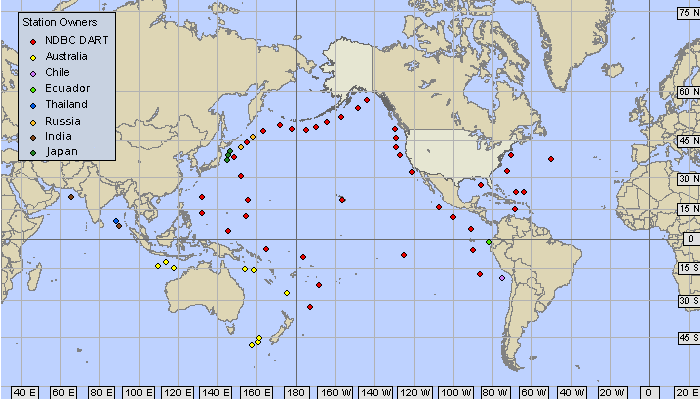
The current deployed DART location (from NDBC) are shown on a map.
These can also be viewed with the NGDC interactive map (choose DART stations.


More information about DART®  
Home | Tsunami Forecasting | Hazard Assessment | Research | DART | Events | Info
NOAA   NOAA Center for Tsunami Research   JISAO
US Department of Commerce | NOAA | OAR | PMEL
7600 Sand Point Way NE
Seattle, WA 98115
Contact Us
About | Privacy Policy | Disclaimer