Groundwater Systems

The Groundwater Systems team discussing a project in the field.
The team's investigations provide data on Wisconsin groundwater that enables proper management of resources and facilitates an understanding of groundwater quantity and quality.
The Groundwater Systems Team conducts scientific investigations into ground water in Wisconsin.
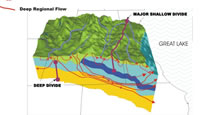
Groundwater is all fresh water below the land surface that supplies aquifers, wells, springs, and water in the zone of saturation where all openings in rocks and soil are filled. The upper surface of ground water forms the water table. Although ground water and surface water are interconnected, projects that have ground water as the primary focus are grouped here.
Team membership fosters a close working relationship with cooperators and the University community. The team provides cooperators with state-of-the-art techniques and expertise to provide an understanding of the relation of groundwater systems to other natural resources and humans. The team provides technical review for existing groundwater projects and designs and presents proposals to cooperators.
The Wisconsin Water Science Center is currently conducting groundwater-related cooperative projects with the Wisconsin Department of Natural Resources (WDNR), UW Systems, UW-Extension through the Wisconsin Geological and Natural History Survey [WGNHS] and Center for Land Use Education [CLUE], Southeast Wisconsin Regional Planning Commission (SEWRPC), the, Mole Lake and Lac Du Flambeau Tribes of Wisconsin, the US Forest Service, and numerous county and city governments. The federal funds that support these projects come from the Cooperative Water Program, an ongoing partnership between the USGS and non-Federal agencies (http://water.usgs.gov/coop/). In addition the Wisconsin Water Science Center conducts projects that are funded entirely by USGS Federal programs. All recent and current projects that have a significant groundwater component are listed below.
Projects funded cooperatively with state and local agencies:
- Operation and maintenance of the Wisconsin Observation Well Network; data collection, processing, archiving, and presentation (with WGNHS).
- Development of the Water Use in Wisconsin summary report (produced at a 5-year interval); data collection and estimation, development of water-use coefficients and default values; evaluation compiled by aquifer, geographic, and political criteria (with WDNR).
- Simulation of groundwater/surface-water systems in the vicinity of Chenequa, Wisconsin using Local Grid Refinement of the SEWRPC southeast Wisconsin groundwater-flow model (with Village of Chenequa and SEWRPC).
- Evaluating land use and climate change effects on a southern Wisconsin trout stream - results of the Black Earth Creek modeling study (with WDNR and local communities and augmented by USGS Federal funds).
- Assess the breeding range contraction of Great Lakes area Common Loons resulting from the alteration of habitat characteristics sensitive to climate change (with WDNR).
- Simulation of groundwater/surface-water systems and wellhead protection in two tribal areas ( with the Mole Lake and Lac du Flambeau Tribes).
- Simulation of the effects of water diversion from Shell Lake, Washburn County, on the shallow groundwater – lake system (with the City of Shell Lake and the WDNR).
Wisconsin projects funded entirely by USGS:
- Availability and use of fresh water in the United States: Lake Michigan Pilot Study http://water.usgs.gov/ogw/gwrp/activities/wateravail_pilot.html.
- Relation between groundwater flow and beach health (water quality) at Horseshoe Bay in Door County
- Hydrologic and biogeochemical budgets in temperate lakes and their watersheds, northern Wisconsin Long Term Ecological Research site, http://wi.water.usgs.gov/webb/.
- Western Lake Michigan Drainages National Water-Quality Assessment http://wi.water.usgs.gov/wmic/index.html.
- Spatial and temporal shallow groundwater recharge rates in Wisconsin.
- Great Lakes Restoration Initiative work on forecasting effects of future climate and land use change.
Publications
Buchwald, C.A., 2009, Water use in Wisconsin, 2005: U.S. Geological Survey Open-File Report 2009-1076
Buchwald, C.A., Luukkonen, C. L., and Rachol, C. M., 2010, Estimation of groundwater use for a groundwater-flow model of the Lake Michigan Basin and adjacent areas, 1864–2005: U.S. Geological Survey Scientific Investigations Report 2010–5068, xx p.
Dripps WR (2003) The spatial and temporal variability of groundwater recharge within the Trout Lake basin of northern Wisconsin. PhD Thesis, University of Wisconsin, Madison, WI, USA.
Dripps, W.R., and Bradbury, K.R., 2007, A simple daily soil-water balance model for estimating the spatial and temporal distribution of groundwater recharge in temperate humid areas: Hydrogeology Journal 15: 433-444.
Feinstein, D.T., Hunt, R.J., and Reeves, H.W., 2010, Regional groundwater-flow model of the Lake Michigan Basin in support of Great Lakes Basin Water Availability and Use Studies: U.S. Geological Survey Scientific Investigations Report 2010-5109, XXX p.
Hunt, R.J., Walker, J.F., and Doherty, J., 2008, Using GSFLOW to simulate climate change in a northern temperate climate, p. 109-113 in MODFLOW and More 2008: Ground water and public policy, Proceedings of the 9th International Conference of the International Ground Water Modeling Center. Golden, CO: Colorado School of Mines.
Juckem, P.F., 2009a, Simulation of the regional ground-water-flow system and ground-water/surface-water interaction in the Rock River Basin, Wisconsin: U.S. Geological Survey Scientific Investigations Report 2009-5094, 38 p. http://pubs.er.usgs.gov/usgspubs/sir/sir20095094
Juckem, P.F., 2009b, Simulation of the groundwater-flow system in Pierce, Polk, and St. Croix Counties, Wisconsin: U.S. Geological Survey Scientific Investigations Report 2009–5056, 53 p. http://pubs.usgs.gov/sir/2009/5056/
Markstrom, S.L., R.G. Niswonger, R.G., Regan, R.S., Prudic, D.E., and Barlow, P.M.. 2008, GSFLOW—Coupled ground-water and surface water flow model based on the integration of the Precipitation-Runoff Modeling System (PRMS) and the Modular Ground-Water Flow model (MODFLOW-2005). USGS Techniques and Methods 6-D1. Reston, Virginia: USGS.
National Research Council, (edited by R. Bitterli) 2002, Estimating water use in the United States; A new paradigm for the national water-use information program: Washington D.C., National Research Press, 176p.
Saad, David A., 2008, Agriculture-Related Trends in Groundwater Quality of the Glacial Deposits Aquifer, Central Wisconsin: Journal of Environmental Quality 37:S-209-S-225 (http://jeq.scijournals.org/content/vol37/5_Supplement/)
Steuer, J.J., and Hunt, R.J., 2001, Use of a Watershed-Modeling Approach to Assess Hydrologic Effects of Urbanization, North Fork Pheasant Branch Basin near Middleton, Wisconsin. USGS Water-Resources Investigations Report 01-4113. 49 p.
Westenbroek, S.M., Kelson, V.A., Dripps, W.R., Hunt, R.J., and Bradbury, K.R., 2009, SWB - A modified Thornthwaite-Mather Soil Water Balance code for estimating groundwater recharge. U.S. Geological Survey Techniques and Methods 6A31, 65 p.Westenbroek, S., Hunt, R.J., Hay, L.E., and Markstrom S. L., 2009, Coupled Surface-Water/Groundwater Model Response to Climate and Land-Use Change: Black Earth Creek, Wisconsin American Water Resources Association 2009 Spring Specialty Conference - Managing Water Resources Development in a Changing Climate, Anchorage, AK
|