|
|
| Cascades Volcano Observatory, Vancouver, Washington |
| Visit A Volcano |

Baker01_aerial_view_mount_baker_03-21-01.jpg Aerial view, Mount Baker, Washington. USGS Photograph taken March 21, 2001, by Ken McGee. [medium size] ... [large size] |
| Mount Baker Volcano |
| Points of Interest |
| To Get There |
|
Mount Baker:
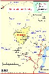
Mount Baker is approximately 50 kilometers (30 miles) east of Bellingham, Washington. The best view of the mountain is from the Glacier Creek Road off of Highway 542. On the south side of the mountain Forest Service Road 372, taking off from Baker Lake Road, ends near the Schreibers Meadow cinder cone. -- Driving excerpt from: Wood, 1990, IN: Wood and Kienle, 1990, Volcanoes of North America: United States and Canada: Cambridge University Press, 354p. |
| Location Maps |


| Useful Links |
| For More Information |
 Mount Baker Menu
Return to:
[Visit A Volcano Menu] ...
[Mount Baker Volcano Menu]

![[medium size]](https://webarchive.library.unt.edu/web/20130218105544/http://vulcan.wr.usgs.gov/Imgs/Jpg/Baker/Images/Baker01_aerial_view_mount_baker_03-21-01_med.jpg)
![[large size]](https://webarchive.library.unt.edu/web/20130218105544/http://vulcan.wr.usgs.gov/Imgs/Jpg/Baker/Images/Baker01_aerial_view_mount_baker_03-21-01.jpg)