

|
|
|

Turbulent wave clouds |
Forecast Clear Air Turbulence Index Images |
 Latest RUC TI
|
Brief Explanation of Product
Images of Deformation-Vertical
Shear Index (DVSI) forecasts for Clear-Air Turbulence
(CAT) are globally produced using data from the National Center
for Environmental Prediction (NCEP) Global Forecast System (GFS) (formerly Aviation), Rapid Update Cycle (RUC)-2, and NAM (formerly ETA) forecast models. The
DVSI available on this page is calculated for the layer from 30,000 ft to 34,000 ft, which is
the normal cruising altitude for commercial jet airliners (a higher layer is available for the Alaska region). Gridded index
values have been converted to a color enhanced image for easier interpretation.
The images provide guidance on potential areas of non-convective turbulence,
excluding mountain waves. They are intended to be used for a quick assessment
by travelers or pilots of the possibility of high altitude CAT conditions.
GOES Water Vapor Loops:
CONUS |
Atlantic |
Pacific
Latest NAM 12hr or 18hr
Forecast with Turbulence
PIREPs
Region
Projection
Model
Levels
Forecast
Period
24hr Loops
N. Hemis.
Polar
GFS
FL300-340
NHem 6hr
NHem 12hr | NHem Archive
NHem 18hr
NHem 24hr
NHem Loop
Alaska
Polar
GFS
FL300-340
AK 6hr
AK 12hr | AK Archive
AK 18hr
AK 24hr
AK Loop
Alaska
Polar
GFS
FL300-340
AK 36hr
AK 48hr
Alaska
Polar
GFS
FL340-390
AK39 6hr
AK39 12hr | AK39 Archive
AK39 18hr
AK39 24hr
AK39 Loop
Alaska
Polar
GFS
FL340-390
AK39 36hr
AK39 48hr
Pacific
Mercator
GFS
FL300-340
Pac 6hr
Pac 12hr | Pac Archive
Pac 18hr
Pac 24hr
Pac Loop
Atlantic
Mercator
GFS
FL300-340
Atlc 6hr
Atlc 12hr | Atlc Archive
Atlc 18hr
Atlc 24hr
Atlc Loop
Cont. U.S.
Lambert
NAM
FL300-340
US 6hr
US 12hr | US Archive
US 18hr
US 24hr
US Loop
Cont. U.S.
Lambert
RUC-2
FL300-340
3hr RUC
RUC 3hr Archive
6hr RUC
Image Interpretation
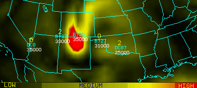
Example of Deformation-Vertical Shear Index (DVSI) forecast image with aircraft reports |
Yellow areas denote where there
is a good chance (50% or better) of occasional moderate or greater clear-air
turbulence (CAT). Red shows where there is a high risk of occasional moderate
or greater CAT. There is little or no correlation between high index values and the
likelihood of severe turbulence. The valid time of the image is shown in
the lower right. Aircraft reports plotted on the 12 or 18 hr
forecast show turbulence intensity in yellow (0 = None, 1=light, 2=light/moderate,
3=moderate, 4=moderate/severe, 5=severe, 6=extreme), aircraft type in cyan,
and flight altitude (feet) in white. The GFS and NAM models are both updated by 1 PM and 1 AM EST daily. RUC-2 products are updated hourly (currently only between 0000 and 1800 UTC).
Archive images are available for
the 12 hr forecast at both 0000 and 1200 UTC. The format is: hhZyyyyjjj.GIF
where hh is model time, yyyy is year, and jjj is Julian day
|
NOTE! When you click on any of the following links you will be leaving the FPDT Web site to go to other NOAA sites.
Jump to: Icing |
Microbursts |
Fog |
Volcanic Ash |
Winds |
Soundings
Operational Products Development Branch
| Privacy Policy | Disclaimer | Information Quality |
|
US Dept of Commerce - NOAA - NESDIS |
Problems or questions? Contact Ken Pryor
. http://www.star.nesdis.noaa.gov/ |