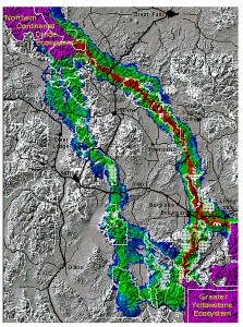
The figure shows possible grizzly bear corridors. The corridors in this figure are color-coded, with warmer colors indicating better areas of habitat connectivity. Bottlenecks are indicated in parts of the corridors which are more constricted. The first and second best major corridor routes for grizzly bears are depicted, with one route being superior to others. According to our work, the potential corridor offering the best chance of successful transit consists of the Gallatin, Bridger, and Big Belt mountain ranges. A secondary route for bears, far inferior to the primary in this analysis, is comprised primarily of the Taylor-Hilgard, Gravelly, Tobacco Root, Whitetail/ONeil, and Boulder mountain ranges.
In this project, researchers delineated landscape routes offering the best chance of success for wildlife moving among the three large core protected areas in the Northern Rockies — the Salmon-Selway, Northern Continental Divide, and Greater Yellowstone Ecosystems. Using ARC/GRID and Montana Gap Analysis data, they derived habitat suitability models for three umbrella species, which were combined with road density information to create kilometer-scale cost surfaces of movement. For each of the three species — grizzly bear, elk, and cougar – analysts performed a least.cost.path analysis to locate broad potential corridor routes. From this first approximation they identified probable movement routes and as well as critical barriers, bottlenecks, and filters where corridor routes intersected with high.risk habitat. This analysis is being used to identify priority areas for wildlife management to improve the connectivity between the core protected ecosystems in the Northern Rockies.
References:
Walker, R., and L. Craighead, Least-Cost-Path Corridor Analysis: Analyzing Wildlife Movement Corridors in Montana Using GIS, Proceedings of the 1997 ESRI User’s conference.


