Raster Data Gateway
FSTopo or Primary Base Series (PBS) Maps
 FSTopo or PBS are 1:24,000 scale topographic maps. They are available in two formats; Geo-enabled PDFs containing all the collar information; and Geotiffs that contain both collar and non-collar editions in a single zipped file. The FSTopo maps replace the old PBS Softcopy fromerly available from this site.
Locate Maps by State or Forest Service Region.
Digital Elevation Models (DEMs)and Digital Orthophoto Quadrangles (DOQs) are distributed by the U.S. Geological Survey. Visit the USGS distribution site at http://EarthExplorer.usgs.gov.
Caribbean Island Land Cover
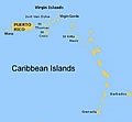 Land Cover and Forest Formations data are downloadable, and include the following: Puerto Rico and its outlying islands of Vieques, Culebra, and Mona; the U.S. and British Virgin Islands; and five islands of the Lesser Antilles: St. Kitts, Nevis, St. Eustatius, Grenada and Barbados.
National Forest Type Dataset
 This geospatial dataset was created by the USFS Forest Inventory and Analysis (FIA) program and the Remote Sensing Applications Center ( RSAC) to show the extent, distribution, and forest type composition of the nation’s forests.
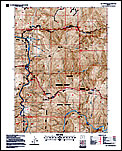
Secondary Base Series (SBS) Maps
 SBS maps for the coterminous United States are produced at a scale of 1:126,720 and are used to produce Forest Visitor Maps (FVM). The FVM's serve as a public recreation map for Forest Service and National Grasslands and other customized purposes.) to show the extent and distribution of forest biomass across the Lower 48 States and Alaska.
National Forest Biomass Dataset
 This geospatial dataset was created by the USFS Forest Inventory and Analysis (FIA) program and the Remote Sensing Applications Center (RSAC) to show the extent and distribution of forest biomass across the Lower 48 States and Alaska.