NESDIS News Archive
While watching Hurricane Sandy, NOAA satellites help save lives
November 7, 2012
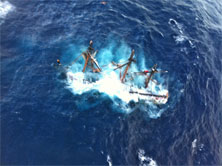
Coast Guard rescues crewmembers aboard HMS Bounty
View Larger
Suitland, Md. -NOAA satellites played a key role in saving lives, as far as 3,000 miles away, while they also helped forecasters accurately predict the speed and path of Hurricane Sandy.
On October 26, a 37-year-old woman injured her back when her All Terrain Vehicle crashed in a remote area of Barrow, Alaska. The group she was riding with activated their Personal Locator Beacon (PLB). The distress signal was picked up by a NOAA satellite, relayed to the U.S. Mission Control Center at NOAA's Satellite Operations Center in Suitland, Md., and then distributed to the Alaska Rescue Coordination Center (RCC). The U.S. Coast Guard, in coordination with the RCC, made the rescue. The woman is hospitalized in stable condition.
NOAA's polar-orbiting and geostationary satellites are part of the international Search and Rescue Satellite-Aided Tracking system, or Cospas-SARSAT. The satellites detect distress signals from emergency beacons carried on ships, airplanes or handheld PLBs.
On October 29, NOAA satellites were also instrumental in the rescue of 14 people when the force from Sandy pushed them from the tall ship HMS Bounty into the choppy waters, 207 miles off the coast of Wilmington, N.C. When the ship sank, its emergency beacon activated automatically. The Coast Guard initiated the rescue. One crew member was pronounced dead at the hospital. The search for the ship's captain was suspended after four days.
"NOAA satellites help save lives -- whether it's forecasting the next hurricane, tornado, flood, or detecting the next distress signal from anyone in a life-threatening situation," said Mary Kicza, assistant administrator of NOAA's Satellite and Information Service in Silver Spring, Md.
Since its inception in 1982, Cospas-SARSAT has been responsible for the rescue of more than 30,000 people worldwide and nearly 7,000 in the United States and its surrounding waters.
An interactive map, with details of the rescues so far in 2012 can be found at: http://www.nesdis.gov/SARSAT_Rescues.html.
For more information about Cospas-SARSAT, visit: http://www.sarsat.noaa.gov.
Related Article(s)
---