United States Department of Agriculture
Natural Resources Conservation Service
West Virginia Go to Accessibility Information
Skip to Page Content


Shavers Fork Fish Habitat Improvement

end-bench-at-boulders-on-left-bank---j-hook---pool Environmental mitigation work was required to compensate for the resources impacted by the Elkwater Fork water supply dam construction.  The off-site component includes the use of natural-stream restoration methods to improve aquatic habitat on about four and a-half miles of trout stream including enhancement or creation of pools, adding riparian vegetation, narrowing over-widened sections, and creating woody fish habitat. Fish habitat improvements will improve the conditions in the Shavers Fork River to support a naturally sustainable brook trout population. Randolph County is a recreation destination. The mitigation projects supplement recreational opportunities.

Construction Status Map August 8, 2012 Construction Status Map August 8, 2012

(Click on map to enlarge)

This document requires Adobe Acrobat.
Construction Status Map August 8, 2012 (1 MB)


Upper Shavers Fork – Before and After Photographs

Station 434 - Shallow Pool Downstream of Rocky Run 
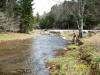
Station 434 - Shallow pool downstream of rocky run (before).
Station 434 – Pool Deepened to Provide Fish Habitat, Cover & Thermal Refugia 
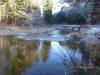
Station 434 – Pool deepened to provide fish habitat, cover and thermal refugia (after).
Station 435 - View Upstream (Before) showing over-wide channel, formation of mid-channel bars, and unstable banks. 
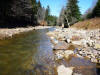
Station 435 - view upstream showing over-wide channel, formation of mid-channel bars, and unstable banks (before).
Station 435 – Showing Lower Width-Depth Ratio, Stabilized Bank, and Defined Thalweg. These improvements just downstream of Rocky Run provide better fish passage and cover during low flow periods. Narrowing the stream provides a better chance for natural re-forestation up to the streambanks, which benefits fish in many ways, including cover, organic matter, and cooler water temperatures for native brook trout. This photo was taken shortly after construction so the site did not have time to re-vegetate. Station 435 – Showing lower width-depth ratio, stabilized bank, and defined thalweg. These improvements just downstream of Rocky Run provide better fish passage and cover during low flow periods. Narrowing the stream provides a better chance for natural re-forestation up to the streambanks, which benefits fish in many ways, including cover, organic matter, and cooler water temperatures for native brook trout. This photo was taken shortly after construction so the site did not have time to re-vegetate (after).
Station 437 – Unstable streambank and no fish habitat Station 437 – Unstable streambank and no fish habitat (before).
Station 437 – After construction with J-Hook vane installed with a deep pool and the streambank stabilized Station 437 – Construction with J-Hook vane installed with a deep pool and the streambank stabilized (after).
 
Station 441 – Wide channel with poorly defined thalweg (before). Station 441 – Wide channel with poorly defined thalweg (before).
Station 441 – Narrowed Channel with Well-Defined Thalweg using Single Wing Deflectors Station 441 – Narrowed channel with well-defined thalweg using single wing deflectors (after). (The flow in this “after” photo is lower than in the “before” photo)
Problem Areas for 2012 Construction Season
These photos represent common problems being corrected by this fish habitat improvement project. These common problems include unstable eroded banks, lack of stream access to floodplain, lack of defined thalweg for fish migration during dry periods, over-wide areas that contribute to higher stream temperatures in the summer, lack of deep pools, lack of woody debris, and other habitat deficiencies.
Station 465 – Fallen Blocks will be replaced with Station 486+35 – Eroded streambank will bea bankfull bench and J-Hook rock vane Station 465 – Fallen Blocks will be replaced with a bankfull bench and J-Hook rock vane.
Station 486+35 – Eroded streambank will berepaired using brush mattresses & large woody debris Station 486+35 – Eroded streambank will be repaired using brush mattresses & large woody debris.
Station 510 – Straight and wide stream reach will be narrowed using alternating single wing deflectors and thalweg enhancement. Station 510 – Straight and wide stream reach will be narrowed using alternating single wing deflectors and thalweg enhancement.
Station 558 – Eroded bank will be stabilized usingbe narrowed using alternating single wing toe wood and reinforced earth with live stakes. The deflectors and thalweg enhancement. use of toe wood will create fish habitat where it is currently absent. Station 558 – Eroded bank will be stabilized using toe wood and reinforced earth with live stakes. The use of toe wood will create fish habitat where it is currently absent.

This document requires Adobe Acrobat.
Upper Shavers Fork – Before and After Photographs (1628 KB)

For additional information in West Virginia contact:

Contact Person Title Telephone Number e-mail Address
TJ Burr Civil Engineer 304-284-7596 Tee.Burr@wv.usda.gov

< Back to Programs