 Hot Stuff
from the
GOES Project
last updated 12 February 2013

This page is a list of brief captions for a scrapbook of all the GOES weather satellite pictures collected by the GOES Project Scientist at NASA since 1994.
The most recent items are at the top of the list.
Other GOES image archival web sites are listed at the bottom of this page.
For more information about an image, click on the caption's trailing icon --  .
.
If a large file fails to download in your browser, use anonymous FTP
ftp://goes.gsfc.nasa.gov/pub/goes_scrapbooks/
2013
2012
2011
2010
2009
2008
2007
2006
2005
- Hurricane Epsilon in mid-Atlantic (1.5 MB JPG) 4 December 2005
- Hurricane Beta in Nicaragua (1.5 MB GIF) 30 October 2005
- Double-eyed Hurricane Wilma (0.1 MB JPG) 25 October 2005
- A week of Hurricane Wilma (51 MB QT) 18-24 October 2005
- Hurricane Wilma eyes Cozumel (4.1 MB QT) 21 October 2005
- Hurricane Wilma has a tiny eye (1.1 MB GIF) 19 October 2005
- Hurricane Vince and a big brother (1.0 MB GIF) 9 October 2005
- Santa Ana volcano (0.6 MB QT) 1 October 2005
- Hurricane Otis and Pacific ship-tracks (4.0 MB GIF) 30 September 2005
- Hurricane Rita movie (14 MB QT) 19-24 September 2005
- Super-rapid eye of Hurricane Rita movie (2.9 MB QT) 23 September 2005
- Super-rapid Hurricane Rita movie (5.2 MB QT) 23 September 2005
- Enhanced Hurricane Rita day-night movie (31 MB QT) 19-23 September 2005
- Enhanced Hurricane Rita color movie (36 MB QT) 19-23 September 2005
- Enhanced hurricane Rita in the Gulf (1.6 MB JPG) 23 September 2005
- Enhanced hurricane Rita in the Gulf (1.0 MB JPG) 22 September 2005
- Hurricane Rita in the Gulf (2.2 MB GIF) 21 September 2005
- Hurricanes Jova, Kenneth, and Max in the Pacific (1.0 MB GIF) 21 September 2005
- Hurricane Ophelia movie (10 MB QT) 6-16 September 2005
- Hurricane Ophelia (1.5 MB GIF) 12 September 2005
- Hurricanes Ophelia, Nate, and Maria (9 MB GIF) 8 September 2005
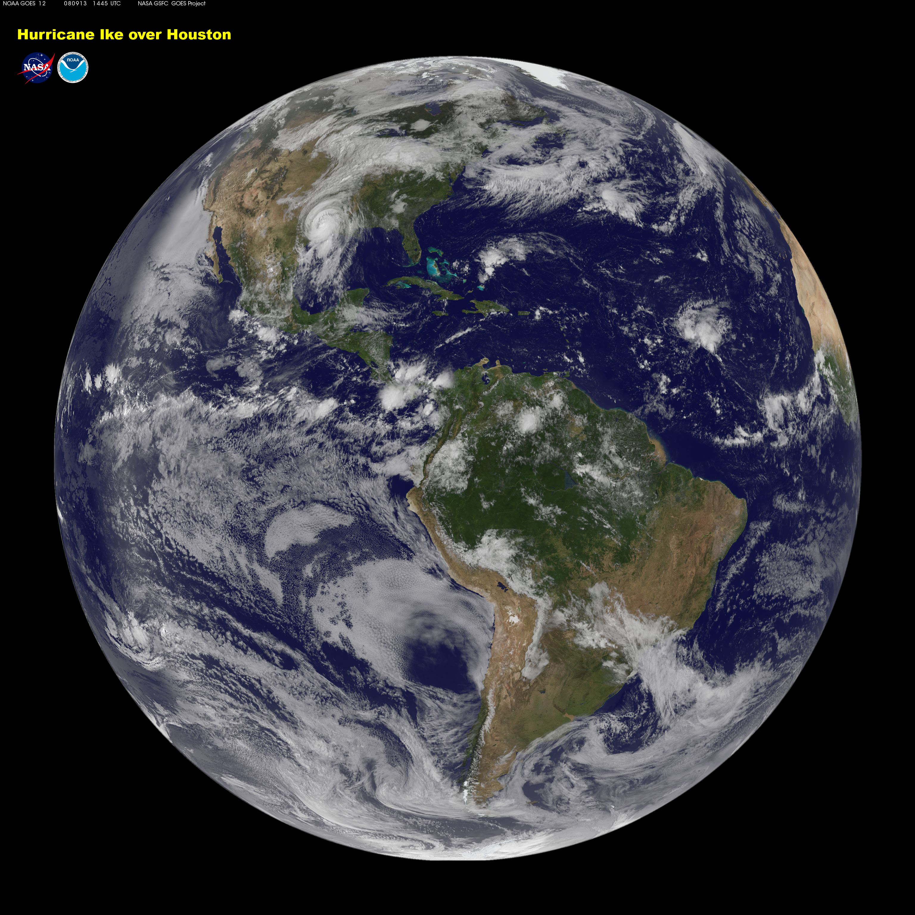
- Hurricane Katrina landfall (6.2 MB JPG) 29 August 2005
- Katrina commemorative poster, front (89.1 MB PDF)
- Katrina commemorative poster, back (2.3 MB PDF)
- Hurricane Katrina movie (12 MB QT, small screen, Sorensen format) 24-29 August 2005
Enhanced Katrina movies - GOES images over a MODIS true-color background
- Hurricane Katrina movie (145 MB QT, small screen, Sorensen format)
- Hurricane Katrina movie (215 MB MPEG, big screen, MPEG-1 format)
- Hurricane Katrina movie (197 MB QT, big screen, H264 format)
- Hurricane Katrina movie (39 MB AVI, big screen, H264 format)
- Hurricane Katrina movie (4.2 MB MP4, iPod screen, H264 format, silent)
- Hurricane Katrina movie (5.5 MB MP4, iPod screen, H264 format, music)
- Hurricane Katrina movie (6.1 MB QT, small screen, H264 format, music)
If a large file fails to download in your browser, use anonymous FTP
ftp://goes.gsfc.nasa.gov/pub/goes_scrapbooks/QTmovies/
- Hurricane Katrina in the Gulf (1 MB GIF) 28 August 2005
- Hurricane Emily (21 MB QT) 16-21 July 2005
- Hurricane Dennis (26 MB QT) 7-11 July 2005
- Tropical Storm Adrian heads northeast (1.1 MB GIF) 19 May 2005
- Springtime Gulf Stream (500 kB JPG) 13 May 2005
- Night watch of St. Helens volcanic ash (1.3 MB QT) 9 March 2005
- Mount St. Helens belches at sunset (300 kB GIF) 9 March 2005
2004
2003
2002
2001
2000
1999
1998
1997
1996
1995
- Christmas stereo December 26
- QuickTime movie of the globe during 2 cold days in the USA December 15
- GOES Data on the Internet - A Tutorial December 2
- Volcanic plume from Cerro Negro in Nicaragua December 1
- Gas-N-Goes November 21
- Shuttle launch observed November 12
- Hurricane Tanya in mid-Atlantic November 11
- NOAA's GOES-9 science schedule for November 95 November 1
- Sharp snow fields in Dakota October 26
- Shear madness at the African limb October 25
- Sebastien is a Scorpio(n) October 22
- African dust storm seeds the Atlantic October 20
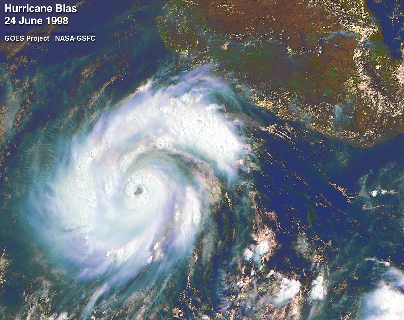
- HOT multi-spectral picture of Hurricane Roxanne over Bay of Campeche October 14
- Multi-spectral picture of Hurricane Roxanne over Bay of Campeche October 12
- Colorized picture of Hurricane Opal at the Gulf Coast October 12
- Multi-spectral picture of Hurricane Roxanne over Yucatan October 11
- Colorized picture of Hurricane Marilyn washing out St. Thomas October 7
- Close-up movie of Hurricane Luis in mid-Atlantic (12 MByte QT) October 7
- Large-scale movie of Hurricane Luis in mid-Atlantic (7 MByte QT) October 7
- Colorized picture of Hurricane Luis in mid-Atlantic October 7
- Hurricane Opal at the Gulf Coast October 5
- GOES-9 on drugs October 2
- Hurricane nursery viewed simultaneously from GOES-8 and -9 October 1
- Hurricane Luis in red-green stereo and in dither stereo September 25
- Upper-atmospheric low pressure system spins over the Sargasso Sea September 23
- Hurricane Luis eyes the Chesapeake September 21
- Unsaturated IR moon-shots September 19
- GOES-8 and GOES-9 view scenic Utah simultaneously September 17
- Large movie of Hurricane Marilyn in the Lesser Antilles (87 MByte QT) September 15
- Hurricane Luis greets the dawn September 6
- GOES-9 image after emissivity correction September 2
- Fire! (north of Lake Superior) August 30
- March of the Atlantic storms August 26
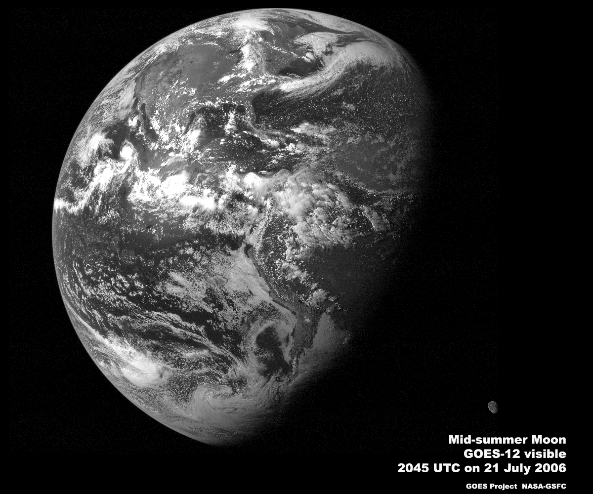
- Moon eclipsed by the Earth August 24
- Shuttle Launch captured by GOES-8 [from CIRA] August 24
- Cape Verde mystery storm August 20
- Hurricane Felix departs, on Friday August 19
- Hurricane Felix off Cape Hatteras on Thursday - a multi-spectral color composite August 19
- Hurricane Felix off CONUS on Thursday, 4 km resolution August 18
- Hurricane Felix off Cape Hatteras on Thursday, 2 km resolution August 18
- Hurricane Felix off Cape Hatteras on Thursday, 1 km resolution August 18
- Hurricane Felix in the Sargasso Sea on Wednesday, 2 km resolution August 16
- Hurricane Felix in the Sargasso Sea on Wednesday, 1 km resolution August 16
- The Moon looks at hurricane Felix on Monday, full earth view August 15
- Hurricane Felix in the Sargasso Sea on Monday, full earth view August 14
- Hurricane Felix in the Sargasso Sea on Monday, 2 km resolution August 14
- Hurricane Felix in the Sargasso Sea on Monday, 1 km resolution August 14
- Hurricane Felix in the Sargasso Sea on Sunday at 2 km resolution August 13
- Hurricane Felix in the Sargasso Sea on Sunday at 1 km resolution August 13
- Hurricane Felix in the Sargasso Sea on Saturday August 12
- Hurricane Erin approaching Florida in color August 8
- Hurricane Erin over Pensacola Florida August 5
- Hurricane Erin over western Florida August 5
- Scattered sunlight in the face of the GOES-8 Imager near midnight:
visible,
3.9 microns,
6.7 microns,
11 microns,
12 microns,
August 5
- Weather radar spots birds August 4
- The heat islands of the East Coast July 31
- GOES-9 rapid scans of South Florida for 12 hours on July 2nd (3.5 MByte MPEG, 360 frames!!) -- first try a small preview movie (250 kbytes, 30 frames) July 26
- The grand canyons of the East Coast July 23
- Tropical Storm Chantal stalled in the Sargasso Sea July 15
- Faint light leak in the GOES-8 Imager's channel 2 July 15
- GOES-9 first full-earth images in all 5 channels, July 12
- 10 day animation of the East Coast last Xmas (3.5 MBytes) July 9
- Summer sunshine movie, July 3
- New Mexico thunderstorm, a rapid scan movie, June 29
- First official GOES-9 full-earth infrared image from June 19 (SSEC's picture), June 21
- GOES-8 "natural color" full-earth image containing Hurricane Andrew at high resolution (WARNING: 10 MByte MacBinary file in Adobe Photoshop 3 format), June 13
- First official GOES-9 full-earth visible image from June 12, June 12
- GOES-9 visible test image from June 9, annotated high-resolution format, June 12
- GOES-9 visible test image from June 9, basic low-resolution format, June 9
- Hurricane Allison, a close up movie, June 9
- Hurricane Allison, a colorized movie, June 7
- Hurricane Allison, large image in garish multi-spectral color, June 7
- Hurricane Allison, small image in muted multi-spectral color, June 6
- Hurricane Allison, in full resolution visible, June 5
- Hurricane Allison, seen in the global context, June 5
- Powerful sunglint from ordinary tropical cloud-tops, May 28
- East-west image shearing is visible at the limb, May 28
- Movie of fog evaporating in valleys of New York and Pennsylvania, May 27
- Movie of GOES-J launch, May 23
- Picture of GOES launch, May 23
- GOES-8 looks for the Panama Canal, May 22
- Movie of storm in Greenbelt, Maryland on May 17th, May 17
- Movie of storm and tornado outbreak in Georgia on May 15th,
along with full-resolution stills at:
2202 UTC,
2215 UTC,
2232 UTC,
2245 UTC,
2315 UTC,
2332 UTC,
2345 UTC,
May 16
- GOES-8 image shear in the canyons of the Sierra Madre, May 7
- Hurricane Gordon in multi-spectral color May 5
- GOES-8 image shear at the mouths of the Potomac and Chesapeake, May 3
- GOES-8 close-ups of the solar eclipse, May 3
- GOES-8's ground track sails through solar eclipse, April 29
- Sunrise over north Africa and the Cape Verde islands, April 29
- Thunderstorms march down Florida (enhanced high-resolution movie), April 23
- Thunderstorms march down Florida (ordinary low-resolution movie), April 22
- Sunglint the river valleys of the North African coast, April 22
- Mini-poster of colorized Sounder channels, April 22
- Enhanced visible image of the full Earth, April 12
- Multi-Spectral image variations on the full Earth, April 2
- Crude multi-spectral QuickTime movie of full Earth for a day, April 2
- Iberia and Morocco at the east limb, March 31
- Movie of rotating contrails caught in a jet March 29
- Morning sunglint off north Africa, March 25
- Tropical cirrus visible at grazing angles near sunset, March 24
- Movie showing 3 days of thunderstorms over Peru, February 27
- Colorized MPEG movie of all 19 Sounder channels February 12
- Example of upper/lower detector striping February 11
- An animated 24 hours on January 5-6th in the 6.7 micron channel January 7
- An animated 24 hours on December 27th in the 11 micron channel January 4
1994
- Jet contrails all over Ohio on Xmas day December 28
- The moon looks very different from GOES-7 and GOES-8 December 25
- Helter-skelter animation results from the NOAA observing schedule December 9
- Water vapor-controlled radiation losses revealed at 6.7 microns, and animated in both MPEG movie format (290 kbytes) and Quicktime movie format (1300 kbytes) November 29
- Brazilian deforestation observed from GOES-8, as routinely observed by Landsat November 23
- Hurricane Gordon November 18
- Tropical storm Gordon, and coastal remnants, November 17
- "Natural color" poster of the globe with GOES-8, November 13
- East-west calibration error in a 11 micron image, October 15
- Multi-spectral combinations using only IR channels, October 13
- Rapid storm development at 1-minute intervals (large images), October 12
- Rapid storm development at 1-minute intervals (small images), October 6
- GOES to Landsat zoom, October 1
- GOES, the friendly satellite, September 29
- Moonshot image from the new GOES antenna system at GSFC, September 21
- Contrails headed for Haiti midday on Sunday, Sept. 18th, September 21
- "Natural color" image of the full globe, September 14
- "Natural color" image of the 3/4 globe, September 10
- "False color" image of the 3/4 globe, September 10
- Sounder channel-by-channel movie and mosaic, August 30
- A day in the life of the GOES-8, August 28
- GOES-7 movie overlaid with national radar, August 14
- The Earth's limb 1 hour before sunset, August 2
- Urban heat islands in the Midwest, August 1
- The Amazon watershed with fires, July 30
- GOES-8 views the Earth limb 2 hours before sunset, July 28
- Multi-spectral view of the Mid-Atlantic states, July 20
- Visible contrails and fog near Vancouver, and in the infrared, July 15
- Thunderstorms over the Midwest at sunset, July 14
- NASA should be able to monitor cloud details using GOES-8, July 8
- Big (2.5 Mbytes each) TIFF images of North America at 4 km resolution, July 6
- False-color image using all visible and IR channels, July 3
- Multi-spectral false-color IR of North America, June 19
- GOES-8 visible, full resolution to the north limb, June 19
- GOES-7 quarter moon, visible, and infrared, June 14
- GOES-7 and GOES-8 visible comparison, June 3
1989
You will need Helper Applications to view TIFF, MPEG, QuickTime, or PDF formats.
Many of our images are large, and in TIFF format, for scientific applications, with technical information in the comment field inside TIFF images.
For science processing of TIFF images, try MultiSpec from Purdue University, a remote sensing image processor for Mac and Windows platforms.
QuickTime movie players are now available for a most platforms.
NASA Web Site Privacy, Security, Notices
NASA standard copyright statement
Everything found here is in the public domain.
Permission is granted to use, duplicate, modify and redistribute images.

Please give credit for the satellite images to:
"NASA-GSFC, data from NOAA GOES"
 NASA Official: Dennis.Chesters@nasa.gov
NASA
Earth Science Enterprise
Goddard Space Flight Center
Earth Sciences Directorate
GSFC Atmospheric Sciences

![Shuttle Launch captured by GOES-8 [from CIRA]](http:../pub/goes/shuttle.launch.jpg)