
World Raster Aeronautical Charts
-
To Print this webpage, please use your browser's print command.
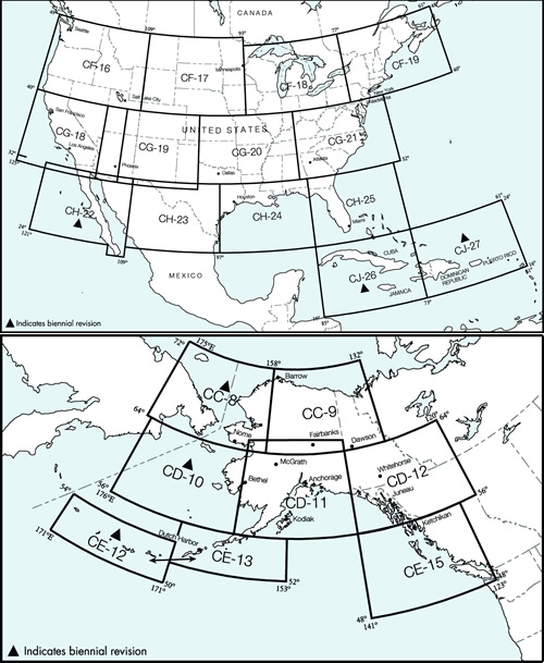
The Federal Aviation Administration (FAA) world raster aeronautical chart series is designed to meet the needs of users who require georeferenced raster images of FAA visual flight rules world charts. A raster world aeronautical chart is a scanned image of an FAA world chart. All information that is part of the paper world aeronautical chart is included in the raster image. The image inside the neat line is georeferenced to the surface of the earth. Georeferencing information for insets should be disregarded, only the main body of the chart is accurately georeferenced.
Most World Raster Aeronautical Charts are provided in two halves, a North side and a South side. The files are 200 dots per inch and 8-bit color. The product is provided as a GeoTIFF and available for public viewing from this website. Information regarding the public sale DVD product is available at: digital - Visual Chart. As each paper wac chart is updated, its raster equivalent is also updated and available for viewing on this website. Please ensure you are using the most current chart by refering to the chart legend.
Download world charts in zip format containing a TIF, geospatial and metadata files.
Files which are in the .zip format will need to be uncompressed using an unzip utility.
Follow the instructions to install the ZIP utility program on your computer.
Should you discover or encounter an error in any of our products, you are encouraged to contact us immediately. Before you do however, please check the Alerts/Notices webpage to see if the error has been previous discovered or resolved. FAA has no effective way to contact every individual that has viewed a digital product; therefore, you are requested to check the Alerts/Notices webpage often.
| Chart Name |
Current Edition No. and Date |
Next Edition No. and Date |
|---|---|---|
| CC8 | 23 - Jan 12 2012 | 24 - Jan 09 2014 |
| CC9 | 41 - May 31 2012 | 42 - May 30 2013 |
| CD10 | 23 - Aug 25 2011 | 24 - Aug 22 2013 |
| CD11 | 42 - Mar 08 2012 | 43 - Mar 07 2013 |
| CD12 | 42 - Jun 28 2012 | 43 - Jun 27 2013 |
| CE-12/13 | 26 - Apr 07 2011 | 27 - Apr 04 2013 |
| CE-15 | 41 - May 03 2012 | 42 - May 02 2013 |
| CF-16 | 42 - Jan 10 2013 | 43 - Jan 9 2014 |
| CF-17 | 42 - Jul 26 2012 | 43 - Jul 25 2013 |
| CF-18 | 42 - Oct 18 2012 | 43 - Oct 17 2013 |
| CF-19 | 42 - Apr 05 2012 | 43 - Apr 04 2013 |
| CG-18 | 42 - Jun 28 2012 | 43 - Jun 27 2013 |
| CG-19 | 42 - May 31 2012 | 43 - May 30 2013 |
| CG-20 | 42 - Jun 28 2012 | 43 - Jun 27 2013 |
| CG-21 | 43 - Sep 20 2012 | 44 - Sep 19 2013 |
| CH-22 | 20 - Sep 22 2011 | 21 - Sep 19 2013 |
| CH-23 | 43 - Sep 20 2012 | 44 - Sep 19 2013 |
| CH-24 | 43 - Aug 23 2012 | 44 - Aug 22 2013 |
| CH-25 | 43 - Dec 13 2012 | 44 - Dec 12 2013 |
| CJ-26 | 20 - Feb 09 2012 | 21 - Feb 06 2014 |
| CJ-27 | 20 - Apr 05 2012 | 21 - Apr 03 2014 |