![The book examines south Florida’s coastal region from Martin County on the east coast to Charlotte County on the Gulf of Mexico coast. South Florida’s entire marine environment is closely linked to upland and upstream influences, such as the Greater Everglades Ecosystem and the Gulf of Mexico. (Credit: University of Maryland’s Integration and Application Network [IAN])](2012/articles/ten_years/globe_arc.jpg)
|
Learning Science the SOS Way: Science On a Sphere® Celebrates 10 years
One of the major challenges facing earth scientists is how to make their research interesting, understandable and memorable to people of all ages. Science On a Sphere® (SOS) is an exhibit that uses video projectors to shine images of the earth onto a giant globe.
|
![The book examines south Florida’s coastal region from Martin County on the east coast to Charlotte County on the Gulf of Mexico coast. South Florida’s entire marine environment is closely linked to upland and upstream influences, such as the Greater Everglades Ecosystem and the Gulf of Mexico. (Credit: University of Maryland’s Integration and Application Network [IAN])](2012/articles/sweet_salty/sweet_salty_arc.jpg)
|
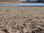
Sweet or Salty, Quality Counts: Sea Grant Prioritizes Clean Water
From the shores of South Carolina to the beaches of Southern California (and in the coastal and Great Lakes states in between), NOAA’s National Sea Grant College Program is working to improve water quality and to enhance peoples’ understanding of groundwater and surface water relationships. The journey begins with a trip to the Great Lakes, where Sea Grant programs are engaged in research and outreach efforts to ensure that these fresh, “sweet” water bodies are as safe and pristine as possible. |
![The book examines south Florida’s coastal region from Martin County on the east coast to Charlotte County on the Gulf of Mexico coast. South Florida’s entire marine environment is closely linked to upland and upstream influences, such as the Greater Everglades Ecosystem and the Gulf of Mexico. (Credit: University of Maryland’s Integration and Application Network [IAN])](2012/articles/fragile_oasis/fragile_oasis_arc.jpg)
|
Florida’s Fragile Oasis
Surrounded by ocean moisture, Florida is an oasis sitting right in the middle of the desert belt, which traverses the subtropical latitudes north and south of the equator. But even oases sometimes go dry. In the 1980s and 1990s, a dramatic population boom and a reliance solely on groundwater tested the limits of this oasis. Learning from those lessons, Tampa Bay Water, a regional water supply authority, has spent the past 20 years diversifying their water supply to include surface and desalinated seawater. Without further innovative thinking and planning, the limits of the oasis might again be tested by further population growth and climate change. |
![The book examines south Florida’s coastal region from Martin County on the east coast to Charlotte County on the Gulf of Mexico coast. South Florida’s entire marine environment is closely linked to upland and upstream influences, such as the Greater Everglades Ecosystem and the Gulf of Mexico. (Credit: University of Maryland’s Integration and Application Network [IAN])](2012/articles/wind_power/wind_power_arc.jpg)
|
Improved Atmospheric Boundary Layer Science Improves Wind Forecasts
Do you remember learning in science class that the atmosphere is divided into four layers: Troposphere, Stratosphere, Mesosphere, and Thermosphere? Perhaps you recall learning that all the Earth’s weather occurs in the Troposphere. But did you know that the lowest portion of the Troposphere, called the Atmospheric Boundary Layer (ABL), is the area most in contact with people and its behavior is directly influenced by what exists and occurs at the surface? Topographical features (e.g., water bodies, mountains, trees, and buildings), surface temperatures, large-scale weather patterns, and cloud cover all play a role in determining the behavior of the ABL. |
![The book examines south Florida’s coastal region from Martin County on the east coast to Charlotte County on the Gulf of Mexico coast. South Florida’s entire marine environment is closely linked to upland and upstream influences, such as the Greater Everglades Ecosystem and the Gulf of Mexico. (Credit: University of Maryland's Integration and Application Network [IAN])](2012/articles/what_name/Daniela_arc.jpg)
|
What’s in a name?
Can a high school intern explore the ocean floor without being at sea? That’s what Daniela Vitarelli recently did with NOAA’s Office of Ocean Exploration and Research (OER) when her interest in geology and physics were matched with OER’s mission to better understand our largely unknown ocean. |
![The book examines south Florida's coastal region from Martin County on the east coast to Charlotte County on the Gulf of Mexico coast. South Florida's entire marine environment is closely linked to upland and upstream influences, such as the Greater Everglades Ecosystem and the Gulf of Mexico. (Credit: University of Maryland's Integration and Application Network [IAN])](2012/articles/tropical_connections/florida_arc.jpg)
|
South Florida: How Are You Connected?
People who vacation, live, boat, swim, snorkel, bird watch, or eat seafood in south Florida are “connected” to south Florida’s marine habitats. With populations increasing in coastal communities such as south Florida it is important to understand the impact humans have on these environments, and how the changing marine environment influences the way we live and how we plan for the future along our coasts. |

|
Bringing Back the Fish: Michigan Sea Grant Oversees Successful Habitat Reconstruction
Michigan Sea Grant is overseeing a long-term restoration project to restore fish spawning habitat for native fish species. An acre of rock reefs were constructed in the Middle Channel of the St. Clair River in the spring of 2012 — and fish are already using the reefs. “It is science in action,” said Jennifer Read, assistant director of Michigan Sea Grant and project lead. "We were still constructing reefs a few hundred feet away, and yet, here they were…
|

|
Drifting Buoys Track Water Currents in the Great Lakes Straits of Mackinac
When you're watching a river or the waves on a lake, do you ever wonder where that water goes? If you threw a rubber ducky into the water, where would it end up? Scientists are studying the movement of water in the Straits of Mackinac, which connect Lake Michigan and Lake Huron, to figure out how the water moves around.
|

|
Innovative Farmers Look to Climate Forecasts for an Edge
From poor soil to scorching summer heat, farmers in the U.S. Southeast face some significant challenges. Two Southeast growers are looking to seasonal climate forecasts to give them an edge.
|

|
NOAA Celebrates Centennial at South Pole
One hundred years after the first explorers reached the South Pole, researchers commemorated the event and showcased the research station located there. NOAA’s Earth System Research Laboratory research programs have been underway at the South Pole since 1957. Researchers have conducted continuous, long-term atmospheric measurements, provided leadership for the Atmospheric Research Observatory, and given scientists the chance to study “the cleanest air on earth”.
|

|
The Essential Team Behind the Scenes of NSSL’s Field Research
The workshop looks like a miniature Home Depot — an organized clutter of soldering guns, wires, and voltage meters. Shelves are stacked with assorted weather instrument packages, antennas, and CB radios. Helium tanks used to fill weather balloons line the walls under whiteboards with concept drawings of instruments. The National Severe Storms Laboratory’s shop and vehicle bay on the ground floor of the National Weather Center in Norman, Okla. is where creativity takes shape and inventions are born.
|

|
Known Unknowns: Exploring New Frontiers in Information Management on Okeanos Explorer
Little Hercules, the remotely operated vehicle (ROV) on NOAA Ship Okeanos Explorer, the only Federal ship to systematically explore our largely unknown ocean, acts as our eyes on the seafloor, recording high definition video of deep-sea creatures, geological structures, and underwater archaeology sites. And when Little Hercules is back onboard the ship, the crew of the Okeanos Explorer is busy mapping the sea floor to find new targets for exploration.
|

|
Scientist Are In
Communicating with the public about scientific topics isn’t easy – even for scientists talking about their own work. A partnership between NOAA and the San Francisco Exploratorium museum is taking steps to train scientists to talk to the public about their work with the benefit of having NOAA research highlighted in one of the premier science centers in the world.
|

|
Rainwater Harvesting: Recycling a Precious Resource
History is replete with accounts of ancient civilizations collecting and storing water for household and agricultural uses. The Romans engineered elaborate aqueduct systems to harness and convey rainwater to cisterns beneath the empire’s population centers. And the North American Anasazi channeled rainwater from mesa tops into stone-lined reservoirs.
|

|
NOAA Research Invites You to “Meet Our Scientists”
“Why does your research matter?” “What would you be doing if you had not become a scientist?” Read short Q and A interviews with NOAA researchers and partners. Put a face on science and get to know our researchers who conduct preeminent research that helps us understand the complex systems that support our planet. Their research helps provide better forecasts, earlier warnings for natural disasters and a greater understanding of the Earth. “To Meet Our Scientists” link here. |

|
Taggers Volunteer to Help U.S. Vets
Project Healing Waters is a cooperative volunteer program that engages disabled veterans in physical and emotional rehabilitation through fly-fishing. With support from Virginia Sea Grant Extension Program, VIMS, Dominion Power and the Virginia Marine Resources Commission, these veterans are gathering data about some of Virginia's favorite game fish. |

|
Clearing up a cloudy view of phytoplankton's role in the climate system
Phytoplankton - tiny plant-like organisms drifting through the great, vast ocean - are barely visible to the nakedeye, and some are visible only through a microscope. Yet, when they are thriving, it is possible to see them from as far away as space. Their location is marked by swirling patterns of bright blues and greens that give the ocean a slick, marbled appearance, like oil on water
|

|
Sea Grant Programs Strike Balance between Protecting Species and Protecting Economies
In commercial fishing, many species end up as "bycatch," caught unintentionally by vessels targeting other fish. Marine mammals and birds can become bycatch, too. Bycatch is accidental and indiscriminate. If bycatch of a certain species within a particular fishery gets too high, the fishery could be shut down, causing economic hardship for commercial fleets and coastal communities - and higher prices for consumers. Through research, education and outreach, NOAA Sea Grant is addressing bycatch from the Gulf of Maine to the Gulf of Mexico to the Gulf of Alaska.
|

|
Travel Around the World and Under the Seas with Ocean Explorer Web Coordinators
Visitors to NOAA's Office of Ocean Exploration and Research (OER) award winning Ocean Explorer website, http://oceanexplorer.noaa.gov, enjoy beautiful imagery, information, and background on the science from nearly 20 missions around the globe each year. There's a lot that goes on behind the scenes in order to create such rich content. During many OER expeditions, a web coordinator travels with the science team to capture and coordinate mission logs, background on the science taking place, and still images and videos that bring these science expeditions to life and take web-based "ocean explorers" along for a virtual mission.
|

|
Human-Impact Disaster Averted Downwind of Chemical Plume
Magnablend Chemical Plant caught fire near the town of Waxahachie, Texas, on October 3, 2011, triggering a liquid inferno that would later spread to a passing train and engulf a fire truck. Billows of smoke blackened the sky for miles around. Luckily for the local Emergency Operations Center, Dallas Fort Worth is one of seven cities where NOAA deployed the experimental Geo-Targeted Alerting System (GTAS), which enables quick access to high-quality forecasts and collaborative decision-making during disasters.
|

|
Fresh, Local and Good for the Community
If you go to the grocery store to buy seafood, chances are that what you end up buying is imported - an 80 percent chance that it is imported, according to NOAA Fisheries Service.
Over the past decade, lower-cost, imported seafood has displaced domestic seafood in many commercial markets. The prevalence of imported seafood now threatens the rich tradition and high quality of regionally harvested seafood. However, by investing in "buy local" initiatives, consumers can invest in their local community and businesses.
|

|
By Air, Land, and Sea: Exploring the Mysteries of the Madden-Julian Oscillation
On any given day, numerous individual thunderstorms pop up across the tropical oceans, their appearance at any specific place and time apparently random. But a half a dozen or so times each year, thunderstorms that form in the tropical Indian Ocean organize like a team of synchronized swimmers and begin a slow eastward stroke, reaching the western edge of South America between 30 and 90 days later.
|

|
National Sea Grant Program "Writes the Book" on Combating Invasive Species
All good books have a beginning, middle, and end. The opening chapter of a "book" called The Nation's Coastal Environments, describes economic plenty, recreational pleasure, and natural beauty. However, as the story unfolds, increasing numbers of invasive species generate nasty plot twists. In fact, according to a Cornell University study several years ago, more than 40 percent of species on the threatened or endangered species list are at risk primarily because of these invaders.
|

|
Experiments Assess Sensors Used in Search for Subsurface Oil
Finding oil beneath the surface of the ocean isn't easy, as those responding to the Deepwater Horizon (DWH) spill learned in the summer of 2010. When oil floats to the surface, it can be seen by aircraft and observers on ships; when it's entrained as small droplets into subsurface clouds and plumes, visual observation becomes impossible. The oil travels at different depths depending on the water conditions, composition of the oil, the size of the droplets, and other factors.
|

|
A Breath of Fresh Air?
Take a deep breath. Go on, a really deep breath. Feels good, doesn't it? Breathing is something you usually don't take much notice of, yet it is vital for your continued survival. Humans can't last more than a few minutes without breathing, taking in oxygen that is needed for each of our body's cells and flushing out unneeded waste materials, primarily carbon dioxide. Each breath you take while at rest is about one half quart in volume. But did you know that with each breath, you also inhale a variety of other substances besides oxygen?
|

|
Coastal and Marine Spatial Planning: NOAA Sea Grant Filling a Crucial Niche
Marine and coastal environments form complex interdependent webs of life where organisms of all sizes interact according to intricate rules of survival. Humans are integral nodes in this web, relying on marine and coastal systems for both livelihoods and recreation in a co-dependent relationship that requires the environment to remain healthy and vibrant.
How can we manage such complex ecosystems in a way that integrates ecological, social, and economic goals? According to the National Ocean Policy, the answer is through Coastal and Marine Spatial Planning (CMSP).
|

|
Push for Great Lakes Forecasting Tools Drives Innovation on Lake Erie Ice Cover
The sight of a blazing orange sun setting behind smooth, seemingly endless blue water might be reason enough for some folks to take a mid-June cruise on Lake Erie.
But for a crew from NOAA's Great Lakes Environmental Research Laboratory (GLERL) on just such a trip this June, it was all about the huge, jagged sheets of ice that covered the lake during the region's freezing grey winter a few months prior.
The crew was out retrieving data-collecting devices that had been moored to the lake floor since the previous fall. Among the devices the crew brought back were ice profilers, which are part of a first-of-its-kind effort to collect a winter's worth of measurements of the thickness and movement of Lake Erie's ice.
|

|
Will Boulder's Water Supply Stand Up to Climate Change?
Nestled in the foothills of the Rocky Mountains is the city of Boulder, Colorado, where Carol Ellinghouse has worked for over two decades as the city's water resources coordinator. On countless walks along wandering mountain trails that overlook the scenic valley, her eyes have skimmed the pockets of green that mark the locations of the city's many parks and open spaces, and in the distance to the east, fields of corn, alfalfa and pasture grass.
Located in the semi-arid western United States, Boulder Valley wouldn't look so green naturally. "We get an average of about 15 inches of rain and snow in the city every year," Ellinghouse explains. "For lawn grass to grow, you probably need somewhere around 30 to 40 inches."
|

|
NOAA Laboratory Brings Climate Model History and Expertise to the IPCC
If the Nobel Peace Prize-winning Intergovernmental Panel on Climate Change (IPCC) were an Olympic race, its contributors would enter as marathoners rather than sprinters.
That's because scientists at climate modeling centers like NOAA's Geophysical Fluid Dynamics Laboratory (GFDL) in Princeton, NJ, devote about six years to improving their climate models used to assess climate change. This is an ongoing research and development process that has engaged GFDL scientists since the 1990s.
Despite this lengthy procedure, many outside the GFDL community are unaware of the herculean effort the lab contributes to the IPCC.
|
 |
Sea Grant's Tsunami Research and Preparedness Programs: Building Hazard Resilience in Coastal Communities
Tsunamis have been a reality for coastal communities for as long as humans have lived near the shore. NOAA Sea Grant has been working with coastal communities for many years to help residents understand the risks, reduce their vulnerability and respond quickly. Hazard resilient coastal communities is one of four major areas of focus for the National Sea Grant College Program. Sea Grant uses its integrated research, training and technical assistance capabilities to help local citizens, decision makers and industries plan for these hazardous events around the U.S. and its territories.
When the 9.0 m Tōhuku earthquake hit on March 11, 2011, it generated a tsunami with 10 meter (30 foot) waves that crashed on the shore of Japan less than a half an hour after the quake. Soon, the waves were racing across the ocean towards Hawaii and the West Coast of the United States.
|
 |
NOAA's Air-Sea Flux System
In the port of Arica, Chile, high above the bow of the research vessel Moana Wave, researchers from NOAA's Earth System Research Laboratory (ESRL) install an instrument system for the upcoming Stratus 2011 experiment in the tropical Pacific Ocean. It isn't the first time this system, developed under the guidance of Chris Fairall of ESRL, has been aboard a ship. The instrument package measures the exchange (or flux) of heat, water, and momentum between the atmosphere and the ocean, and at 20 years old, it now represents a world standard for measuring air-sea interaction.
Up through the early 1980s, most air-sea interaction measurements taken aboard ships were of ocean properties or basic meteorology-made separately. No one was gathering information on the air-sea flux even though it is an important part of understanding and predicting the world's climate systems. Fairall, at the time a professor at Pennsylvania State University, recognized the need for improved understanding and knew there would be significant scientific interest in an integrated system to directly measure fluxes.
|
 |
Sea Grant ensures safe seafood, preventing illness and saving consumers millions
The nation's $60 billion seafood industry employs about 250,000 workers, and the U.S. is the third largest consumer of seafood in the world. To ensure seafood safety, the U.S. Food and Drug Administration (FDA) established strict regulations for handling seafood in 1997. These regulations required all seafood processors to undergo training in the principles of Hazard Analysis and Critical Control Point (HACCP).
Sea Grant programs around the nation provided standardized HACCP training that help businesses comply with FDA requirements and stay in operation. The HACCP programs teach seafood processors, dealers, importers, and inspectors to identify potential biological, chemical, and physical food safety hazards and help them develop plans to control these hazards. This protects consumers by ensuring that all domestic and imported seafood products are processed in the safest manner possible. This training has also been used to design or renovate seafood processing plants to optimize sanitation and efficiency.
|
 |
Have radar -- will travel
The rhythmic clanking sound of the mobile radar dish moving from "stow" to "operate" is strangely comforting to researchers with NOAA's National Severe Storms Laboratory in Norman, Okla. A team in a minivan has already scoured the countryside for a place to set up the radar.
"Municipal airports can make for good sites for long deployments, but a high or flat space with open fields works great for catching a storm," says NSSL researcher Ted Mansell.
All that is required is a place that can hold the weight of a 16-ton truck , a solid place to turn around, and an unobstructed view.
Once it's parked, the mobile radar can deploy in a matter of minutes. The team rushes to place the leveling plates under the truck's stabilizers. The pedestal holding the radar dish groans to life and begins to sweep back and forth. From a workstation in the back of the truck cab, a scientist leans out the window to study the sky and choose the best scan strategy.
|
 |
"Health Food" for the Grid
"With industry's plans to begin extracting significant quantities of energy from the atmosphere-ocean-solar system, we need to understand so much," said NOAA scientist Betsy Weatherhead. NOAA is playing a key role in addressing the urgent need for renewable energy development.
As the nation's leading oceanic and atmospheric research agency, NOAA is directly involved in and poised to contribute to exploring and implementing all types of alternative, renewable, and clean energy sources. NOAA's daily business is about providing the data, knowledge, and technology needed to accelerate integration of renewable energy into the U.S. electric grid.
There are, of course, areas that need improvement. That's why Dr. Weatherhead of the Earth System Research Laboratory (ESRL) in Boulder Colorado jumped at the chance to co-chair with Susan Avery of Woods Hole a well attended panel session at the most recent American Geophysical Union (AGU) meeting.
|
 |
Global Hawk Comes Home to Roost
Six hours into its 26-hour mission, the Global Hawk approaches its destination. The unmanned aircraft's high-definition video camera zeros in on the mission target – a suspected trouble-maker known only as 'Karl'. Back at the Dryden Flight Research Center in California, the aircraft's pilot notifies the mission coordinator that the Global Hawk is in position, with the target in sight. The coordinator relays the information to the five manned aircraft in the target zone, preparing them for their first run. High above the Gulf of Mexico, the aircraft begin their assault.
In this case, Karl is not a renegade drug lord, but a rapidly intensifying hurricane menacing the coast of Mexico. And the Global Hawk is the newest science platform for scientists at the National Oceanic and Atmospheric Administration (NOAA) and the National Aeronautics and Space Administration (NASA) to study and better understand hurricanes and the processes that cause them to quickly increase in strength.
|

|
NOAA's Arctic Report Card Notes Ice Receding, Air Warming-in Region
The Arctic is losing its signature feature – sea ice. Further, warmer conditions have been measured in Greenland, and snow cover duration was at a record minimum this past year. This is according to the 2010 NOAA Arctic Report Card, released Oct. 21.
The NOAA Arctic Report card shows consistent evidence that warming is occurring in the region and a return anytime soon to Arctic conditions of the past 25-30 years is unlikely. Dr. James Overland. of OAR's Pacific Marine Environmental Laboratory, is co-author of the report, along with Jackie Richter-Menge from the Cold Regions Research and Engineering Laboratory. The report was produced by a team of 69 international scientists and is based on 176 published scientific references.
|

|
The Tiksi, Russia Hydrometeorological Climate Observatory
An unusually warm wind swept across the Russian tundra, flapping a row of flags behind a group of international researchers and government officials. Colorfully costumed Yakut dancers commanded the full attention of dignitaries and guests as they performed a native blessing ceremony to mark the grand opening of the Tiksi Hydrometeorological Climate Observatory.
Scientists, officials and members of the small community of Tiksi gathered to celebrate the opening of the Arctic observatory at nearly 72 degrees north latitude. The observatory is a result of collaborations over the past four years among NOAA, the National Science Foundation, the Russian Federal Service for Hydrometeorology and Environmental Monitoring (Roshydromet), the Polar Foundation, and the Finnish Meteorological Institute. The partners worked to finance and equip this remote location for monitoring long-term climate change.
|

|
Science and Social Media – Exploring New Methods of Communicating Research
Now you can get the latest on NOAA's hurricane research programs by accessing a blog site through an RSS feed, Facebook, or a Twitter account.
The Hurricane Research Division (HRD) of NOAA's Atlantic Oceanographic and Meteorological Laboratory (AOML) in Miami, Florida, joins the ranks of notable NOAA entities that are using social media to communicate. The hurricane scientists are blogging about major accomplishments but also revealing the day-to-day planning and science that leads to their successes. HRD follows in the footsteps of NOAA Administrator Jane Lubchenco and the National Severe Storms Laboratory's VORTEX2 tornado project in using social media to communicate with the public.
|

|
Great Lakes Restoration Initiative Science at the Great Lakes Environmental Research Laboratory
Recognizing the significance of the Great Lakes to our nation and the need for action, President Obama has made restoring the Great Lakes a national priority. Through this commitment to restoring the Great Lakes, $475 million was invested in the region in 2010, by way of the Great Lakes Restoration Initiative. "We must leave the Great Lakes better for the next generation than the condition in which we inherited them." - Great Lakes Restoration Initiative Action Plan As one of 15 Federal Agencies collaborating with U.S. EPA to implement this effort, the National Oceanic and Atmospheric Administration (NOAA) was allocated $29.72 million to help accomplish restoration goals using its ground-breaking science, data products and services, prediction, and partnerships.
|

|
Regional Science Fairs Bring OAR Employees Back to Basics
School is back in session for NOAA scientists across the nation. Only now, they take seats behind judging tables instead of wooden, pencil-marked desks— all in an effort to introduce a new generation of science lovers to their profession.
These judges evaluate experiments constructed and presented by elementary, middle and high school students. These experiments range from homemade lava lamps to makeshift sinkholes.
OAR has countless scientists who have served as judges for regional science fair competitions that connect experienced scientists with students.
|

|
Severe weather comes to NSSL's
backyard for study
Nature’s laboratory – featuring an historic ice storm, a tornado outbreak, a billion-dollar hailstorm and record breaking flooding – has enabled scientists at NOAA’s National Severe Storms Laboratory (NSSL) in Norman, Oklahoma, to study up close some of the wildest weather in the world.
NSSL scientists often take observation equipment out into the field to study severe storms. This year, however, a surplus of real-life weather phenomena arrived unbidden at their doorstep in central Oklahoma, enabling a first-hand look for scientists and affecting nearly everyone in the laboratory – either at home or through their research.
|

|
Undersea Research Robots Study Shipwrecks in Northern Gulf
State-of-the-art explorer robots met centuries-old sunken ships under more than a mile of water when the NOAA ship NANCY FOSTER supported an underwater investigation in the Gulf of Mexico last fall.
In October 2009, two highly advanced underwater robots were launched to locate and retrieve information about shipwrecks of historic interest, some of which had disappeared below the water surface almost 200 years ago. The two unmanned and untethered vehicles are designed to operate in water depths of up to 2,200 meters; they use only onboard computers and inertial navigation systems to travel through the ocean and collect data from specific locations on the seafloor.
|

|
Knowing How and Where Harmful Materials Move through the Air Can Save Lives
Whether it’s an accidental or intentional release of harmful materials into the air, local emergency managers need to know how best to respond in order to protect people. However, the atmospheric flow of material can be complex and hard to predict. This is especially true of areas with complex terrain, such as in a city.
Currently, there are models used to forecast the atmospheric transport of materials at large regional scales. There are also models used to focus at the very local scale (within a kilometer of the source). But in between, at a neighborhood-level scale (1-10 kilometers), models tend to be less reliable in forecasting the dispersion of material. Yet, this is where many people live and where exposure to a harmful release potentially has very serious consequences.
|

|
My Month Afloat in the Arctic, with 50 Interesting Strangers
In September, I checked off something I’d never even thought to include on my “to do sometime in life” list: spend a month in the Arctic.
As a public affairs specialist in NOAA’s Office of Ocean Exploration and Research, I was offered a once-in-a-lifetime chance to chronicle the Russian-American Long-Term Census of the Arctic (RUSALCA) Program, through which American and Russian scientists jointly retrieve and deploy monitoring buoys spanning the Bering Strait between the two countries. In 2004 and again this past summer, scientists added a month-long research expedition venturing further north into the Arctic. The multiple science teams on the 2009 RUSALCA expedition studied fish, plankton, water properties, ocean acidification, geology, bottom-dwelling organisms, and microbiology. In addition to American and Russian scientists and graduate students, the ship carried two South Koreans, a German, and a Canadian based in Bermuda.
|

|
Marine trash data the basis for new science curricula
Students in Maine and New Hampshire will soon study trash — specifically, marine debris — to learn more about science and statistics.
School teachers are working closely with the University of New Hampshire and the Blue Ocean Society to incorporate information about marine debris into their lesson plans. Marine debris can include derelict commercial fishing gear that floats offshore, litters the ocean bottom or washes up on beaches. Debris also includes human trash, such as cigarette butts and plastic bags, that washes out to sea.
|

|
Living with an Uncertain Monsoon
In May and June each year, speculation about the coming of the monsoon fills newspapers and conversations across India. Urban dwellers eagerly await respite from overbearing heat. Investors scrutinize forecasts, trying to anticipate possible impacts on food prices. But none have more at stake than India’s more than 100 million farming households.
|
|
NOAA-Funded Research Probes Effect of Climate Change on El Niño
Scientists Note Possible Connection of 1918/1919 El Niño to Flu Pandemic
By any account, 1918 was a difficult year. It saw the end of World War I, a flu pandemic that claimed millions, severe drought in India, and revolutions in four countries. With so much turmoil, it is no wonder the mundane collection of ocean temperature data was not a high priority.
|
| PAGE 22 --
22 | 21 | 20 | 19 | 18 | 17 | 16 | 15 | 14 | 13 | 12 | 11 | 10 | 9 | 8 | 7 | 6 | 5 | 4 | 3 | 2 | 1
|
| 
CLIMATE · OCEANS,
GREAT LAKES, and COASTS · WEATHER
and AIR QUALITY
ABOUT US · RESEARCH
PROGRAMS · EDUCATION · HOME
December 21, 2012 |
|

 ARCHIVE
of SPOTLIGHT FEATURE ARTICLES
ARCHIVE
of SPOTLIGHT FEATURE ARTICLES