
Central and Northern California Region (CeNCOOS)


Map of the Central and Northern California Region Ocean Observing System (CeNCOOS)
The Central and Northern California Ocean Observing System (CeNCOOS) spans the coastal ocean from the California/Oregon border south to Point Conception. The fundamental CeNCOOS approach is to develop long-term monitoring of environmental conditions such as water quality, productivity, and connectivity in support of marine protected area management in central and northern California.
Priorities
For the period 2011-2016, CeNCOOS has established a multi-purpose observational scheme that collectively addresses user needs in the general categories of climate and ecosystem health, water quality, marine operations, and coastal hazards. A sampling of CeNCOOS products to address these issues includes:
- Long time series temperature and coastal sea level data to address global warming and sea level rise
- Sustained observations of the carbon variables to assess ocean acidification
- Observing, predicting, and mitigating the impacts of harmful algal blooms (HABs)
- Creating harbor information pages for marine operators
- Publishing inundation warnings for coastal communities
- Providing real-time currents for search and rescue
- Predicting the movement and fate of harmful spills of all kinds
- Providing ocean data products for coastal and marine spatial planning
News from the Region
Data Portal Upgrades Improve Ocean and Coastal Data Access in California

The portal upgrades provide easy access to information data users need to make decisions to improve safety, the economy, and the environment.
New and better ocean and coastal data is now available in California. The Central and Northern California Ocean Observing System (CeNCOOS), a regional entity of the U.S. Integrated Ocean Observing System (IOOS), recently released a new version of the Data Portal with more than a dozen upgrades. Changes include locations and links to real-time data for 32 high-frequency radar stations that measure ocean surface currents from the shoreline, four new National Weather Service wind stations, and a link to the data portal’s mobile iPhone app, with an Android app to follow soon. Visitors can also obtain regularly updating views of the coast from six mapped webcams, utilize a new graphing system with quicker data plots and depth measurements, and differentiate among real-time (within 24 hours), inactive, and non-real-time data. Users can even apply two new map filter drop-down menus or a new option to display the name, measurements, and organization responsible for an asset.
To access the portal, go to: http://204.115.180.244/CeNCOOS/DataPortal.html
(top)
NOAA Grant to Advance Harmful Algal Bloom Warnings to Protect Public and Animal Health in Coastal California
Read more about the NOAA Press Release
(top)
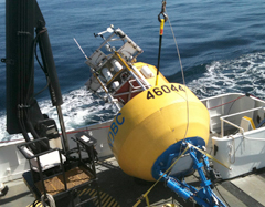
Buoy deployment onboard the R/V Point Sur.
Courtesy of Paul Coenen (MBARI).
Collaborative Monterey Bay Buoy Launch
Unique New Oceanographic Buoy Launched! A new buoy arrayed with instruments from the National Data Buoy Center (NDBC) and Monterey Bay Aquarium Research Institute (MBARI) is currently transmitting data on ocean and weather conditions from offshore Monterey Bay in real-time. CeNCOOS led the effort to bring NDBC and MBARI together for this unique collaboration.
(top)
New on Central and Northern California Region Website: Changing Ocean
Are the ocean and coastal climate of Central and Northern California changing?
Check out CeNCOOS' new webpage which summarizes the types of ocean changes to look for, how they could happen and what recent and historic scientific data tells us. We also discuss forecasts by scientists about ocean changes and which impacts on coastal climate, economies and wildlife may occur.
http://www.cencoos.org/sections/conditions/changing_ocean.shtml
(top)

Buoy deployment onboard the R/V Point Sur.
Courtesy of Paul Coenen (MBARI).
Central and Northern California (CeNCOOS) Data Portal Mobile iPhone App Released!
CeNCOOS Data Portal (CDP) is now available as an app for your iPhone, iPad and iPod Touch! The CDP app gives you access to real-time ocean and coastal weather information from the CeNCOOS region while you are on the go.
Search 'CeNCOOS' at your app store or find out more at iTunes.
(top)
Visit Central and Northern California Region's Website:
Central and Northern California Region Environmental Data Products and Portals
http://www.cencoos.org/sections/
products/index.html
The Central & Northern California Coastal Ocean Observing System (CeNCOOS) has a number of products available online. These include:
- Environmental data products and portals, featuring the CeNCOOS Data Portal iPhone App, real-time ocean satellite images, and the Automatic Identification System (AIS) real-time ship tracking map
- Access to real-time coastal conditions through the CeNCOOS Data Portal, including real-time glider data and High Frequency Radar surface current data
- Ocean and Atmospheric Modeling products, including Monterey Bay conditions and wind and wave forecasts
- Educational material that can be used to teach about ocean observing and algal blooms
CeNCOOS News
http://www.cencoos.org/sections/
news/news_current.shtml
Contact Information
Leslie Rosenfeld, Executive Director
role@mbari.org
Resources
Fact Sheet, 2012 (pdf)
One-Pager, 2011:
IOOS in Action: California (pdf)