
The World According to Peace Corps in 2012
Contact
Press OfficePhone
202.692.2230Fax
202.692.1379Email
pressoffice@peacecorps.gov
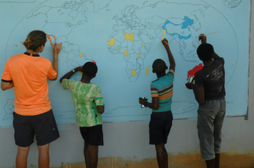
WASHINGTON, D.C., December 21, 2012 – In 1988, Peace Corps volunteer Barbara Jo White was trying to get her students in the Dominican Republic interested in geography, but with no resources for even a map to tack to the wall she was at a loss for how to spur enthusiasm. Then she realized that the best way to get a map on the wall – and to make sure it stayed there – was to paint it.
It took a little coordination and the publication of a resource guide – including painting instructions – for the World Map Project to take off and today many Peace Corps volunteers have either painted a world map or used the existing map at their post to share the world with their host-country community members. World Map Project maps painted with the guidance of Peace Corps volunteers can be seen on at least five of the world’s seven continents.
Creating a world map is possible for any volunteer, regardless of their artistic talent. The most common method is the “grid method,” where every part of the map is broken down into a square section that is easily reproducible. Also included in the instructions is a guide to coloring the map. Many volunteers personalize the map by adding slogans, borders or other designs and adding the names of the countries in the local language.
In 2012, the influence and reach of the World Map Project continued to grow as one of the most popular projects for volunteers during their 27 months of service. In communities rural and urban, Peace Corps volunteers worked with community members to create maps that anyone and everyone can learn from and enjoy. New world maps appeared in 2012 in:
Ecuador
Volunteer Marissa Schaefer of Lawrenceburg, Ind., and Kathleen Wright of Chicago, Ill., completed a

world map with their school’s English teachers and students from the English club. They spent a week turning graffiti-covered walls into a map that will act as a learning tool for the school’s 4,500 students.
“The kids really loved being creative and being involved in something, and it seemed to spark a unity and even more ideas and possible projects,” said Schafer. She said the map has had an impact on students, teachers and the community alike, where everyone involved was given a sense of empowerment.
Paraguay

Julia Pretzlaff of Oakwood Village, Ohio, completed a World Map Project with her Paraguayan community in July 2012. Working with a dozen young Paraguayans ranging from 5 to 18, she painted a 6-feet by 12-feet world map on the wall facing the entrance to the school grounds.
By using a projector instead of the more common grid method, Pretzlaff’s group created the map in two weeks. When they weren’t measuring, drawing, or painting, they spent time practicing English, playing card games and soccer. World Map Projects are a great chance for volunteers to work closely with a small group of dedicated people.
“The community really took notice of the map and it is a beautiful and useful addition to our town,” Pretzlaff said.
Philippines
Julie Crow of Falls Church, Va. organized the students in her high school English class in the

Philippines to create a world map on the wall outside of the school library. The 7-feet by 14-feet map will be used by Crow and the other teachers at her school for geography lessons. The project was so successful that one of her counterparts is planning to paint a map of the Philippines on another wall.
The students helping with the project enjoyed it so much that most days, Crow had to chase them away after the bell rang to convince them to stop painting and attend their next class.
Suriname
Volunteer John Williams of Lutherville, Md., worked with another volunteer to create seven world maps in seven Saramaccan villages in their region. With funding from two local companies, they were able to purchase the supplies and paint the maps. As a result, more than 400 students and adults in the interior of Suriname now have access to the world’s geography. “I enjoyed making the world map because it has sparked an interest in the community – mainly the youth to learn more about world geography,” said Williams, who has been living and working in Suriname since May 2011. “In particular, the kids love learning about where Suriname is located but are always a little disappointed when they compare it to the size of Russia.”
South Africa

Kelsey Griffiths of Solon, Ohio, worked with her South African community to create a world map and also included a map of South Africa alongside to give students a chance to learn more about the geography of their own country. Like many volunteers, Griffiths added personal touches to the map, including the slogan “Misava i ya nwina,” which is Xitsonga for “the world is yours.”
When Peace Corps volunteers lead efforts to paint world maps, they share the world with their communities. In 2012, the maps sparked discussions about geography, art and English for people of all ages. Even after the volunteer cartographer leaves the community, a reminder of their presence and impact remains. Thanks to World Map Projects students, community members and the Peace Corps volunteers themselves have a better understanding of how their countries fit into the world.
For more information about the World Map Project, visit http://theworldmapproject.com/. To view pictures from these World Map Projects and more, visit Peace Corps’ Flickr stream at http://www.flickr.com/photos/peacecorps/sets/72157632300594085/.
Subscribe to the Peace Corps News Mix
Includes news releases, photos, and stories from the field
Peace Corps News Mix