Missouri Water Science Center
East New Haven(OU-4)
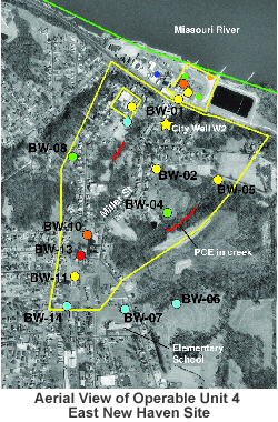
The USEPA began a focused remedial investigation of OU4 in 2003. Currently (2003), the ground-water monitoring network consists of 7 bedrock monitoring well ranging from 65 feet deep (BW-04A-S) to 530 feet deep (BW-07) and an unused well inside an industrial facility immediately northeast of OU-4. Moderate concentrations of PCE (15-30 micrograms per liter) have been detected in a small creek south of monitoring well BW-02. Large PCE concentrations (more than 150 micrograms per liter) have been detected in several bedrock monitoring wells in OU4. Several additional monitoring wells may be installed at OU-4 during 2003. The source of the PCE in OU4 is unknown at this time. A review of historic aerial photographs is being conducted to determine the location of possible disposal sites.
Some files on this site may require the use of Adobe Acrobat Reader; ![]() download the free Adobe Acrobat Reader.
download the free Adobe Acrobat Reader.

Documents specific to Operable Unit No. 4
- Record of Decision (ROD) for Riverfront Superfund Site Operable Unit 4, New Haven Missouri Complete ROD document including figures and tables (PDF File 6.3 MB) (Released March 2009)
- Final Feasability Study Rivervront Superfund Site, New Haven, Missouri Operable Unit 4, The Orchard Street/Maiden Lane Site (PDF file 2.61 MB) (Released November 2008)
- Proposed Plan for Riverfront Superfund Site Operable Units 4, New Haven, Missouri (PDF File 2.8 MB) (Released December 2008)
- Fact Sheet-Public Meeting and Comment Period Riverfront Superfund Site (PDF 32 KB)(Released December 2008)
- Human Health Risk Assessment Report (released July 2008)
- Fact Sheet-Operable Unit 4 Removal Acction Public Session, Riverfront Superfund Site, New Haven, Missouri (PDF 25KB) (released April 2007)


