
Big News: Google Earth 7 Released | New Earth Imagery | Costa Concordia Sim
January 4, 2013
Visualizing cell tower strength with Google Earth
Franz Graf knew he had a shaky mobile connection on his daily commute, but wanted to see just how bad it was. To find out, he wrote an Android app that recorded the GPS position and signal strength along his journey and then plotted all of the data in Google Earth. The result is a great Google Earth KML that shows cell tower strength in his area:

The image above was created with approximately 9,000 data points from his commute. He plans to release the app to Google Play so that others can use it, which I would love to download to drive around my area and see how it does. I have some idea of where the dead zones are, but this would give me a more concrete look at it.
He's released a sample KML file so you can see first-hand how the output looks.
You can read more in his original post on Google+, and then the follow-up post where he plotted it in Google Earth. If he releases the app for others to download, we'll certainly let you know about it.
Posted by mickmel at 6:52 AM
| Comments (1)
January 2, 2013
Explore the Game of Thrones "Westeros" in Google Earth
Google Maps Mania recently posted an entry that featured a variety of maps that help you explore the continent Westeros from the TV series "Game of Thrones".
The map created by theMountainGoat includes a very high-quality Google Earth KML, allowing you to pan and explore every facet of the continent.
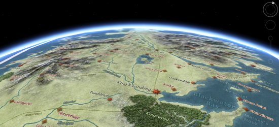
He has a variety of KML files available. The version 2.0 KMZ is very comprehensive, but quite resource intensive. If your computer has difficulty handling it smoothly, the version 1.1 KMZ might work better for you.
Learn more about those files on theMountainGoat's Google Earth page, or see more great Game of Thrones maps in the full post from Google Maps Mania.
Posted by mickmel at 9:08 AM
| Comments (0)
The Year 2012 in Google Earth
Google Earth had a tremendous year in 2012. We saw the release of Google Earth 7.0, which saw the addition of 3D Imagery to the desktop as well as a variety of other great new features.
Beyond that, here were some of our most popular stories of the year:
January
The big story in January was the wreck of the cruise ship Concordia, including rapidly updated satellite imagery and even 3D tours of how the tragedy unfolded.

February
February was relatively quiet, but we saw Street View finally arrive in Russia and the beginning of the GEC move to Google Groups.
March
In March we saw the first release of Street View imagery from the Amazon and Google Earth 6.2 for mobile. We also posted about "Google Earth Live?", which was a speculative post about what Google Earth could be like in the coming decades. However, apparently that's a feature that people want now, as it proved to be one of our most popular posts of the year!
April
In April we saw Street View come to Israel and Ukraine, explored the Titanic 100 years after its famous sinking, and saw some amazing enhancements to the unofficial Google Earth Flight Simulator.

May
In May we got our first look at the excellent Meograph project and took a look at the new One World Trade Center in New York as it become the tallest building in the city.

June
In June we explored the amazing rebirth of Crissy Field in San Francisco and got our first look at Google's remarkable new 3D Imagery.
July
In July we showed you the Project Geo web series (which is still going strong) and helped commemorate the 43rd anniversary of the Apollo 11 mission.
August
In August we saw fresh Street View imagery in New Orleans, Baton Rouge and Lafayette as well as the Kennedy Space Center and we showed you an incredible 360 Panorama from Mars

September
In September we saw new Street View imagery in 150 university campuses and followed the great story of a lost camera being returned home thanks to Google Earth.
October
October was dominated by two big stories related to Google Earth.
The first, of course, was the devastating Hurricane Sandy that hit the east coast of the United States.
The second was the long-awaited release of Google Earth 7 on the desktop, which saw many enhancements including the noteworthy "3D Imagery".

November
November brought us some big updates to Google Mars as well as a lot of neat geo tools to track the 2012 US Presidential Election.
December
In December we showed you NASA's amazing new "Black Marble", finished our months-long Google Earth A to Z series, and of course helped track Santa on Christmas Eve.
All said, it's been a great year for Google Earth! What was your favorite story of the year?
Posted by mickmel at 8:36 AM
| Comments (0)
December 31, 2012
3D Fireworks in Google Earth
In celebration of the new year many people shoot off fireworks, and we love to show off the work of GEB reader 'Steven' who took it a step further and created some great 3D fireworks in Google Earth! As you can read about in his blog, the fireworks are intended to duplicate the 2011 Taiwan New Years Eve show, based on the simulation that you can view here.

As you can see from the photo above, the fireworks aren't just simple animated images -- they're fully 3D! Some of them shoot into the sky, and some wrap around the Taipei 101 tower. As Steven points out in his post, animations like this are only possible because of the work of 3D modelers that created the buildings. In this case, credit goes to user Tang Huang who created the exceptionally detailed model of the Taipei 101 tower.
To see the fireworks in action, you can view them here using the Google Earth Plug-in, download this KMZ file, or watch the video below:
For another fun way to view fireworks, Keir at Google Maps Mania built a map that allows you to view video from celebrations around the world. It's a simple map that does a great job.
Happy New Year!
Posted by mickmel at 8:09 AM
| Comments (0)
December 28, 2012
The Google Earth Time Machine
One of my favorite features of Google Earth is the historical imagery tool. Being able to click a button and view imagery from years past is an amazing. If you're not familiar with this feature, here's a quick overview of how it works:
Taking advantage of this feature, Brian Schrock has set up a blog called the Google Earth Time Machine, which shows comparisons of various locations via the historical imagery tool. A great example are the two images below, which show the results of when a dam was placed on the Berg River in South Africa.

He's also posted some animations that make it easy to see the changes to a particular area. A great example of that is London as they prepared for the 2012 Olympic Games. This image shows the area in 2006, 2008, 2010 and 2012:

Brian has posted dozens of examples over the past few years, and it's worth your time to check them out at googleearthtimemachine.blogspot.com.
(via +Google Earth Community)
Posted by mickmel at 8:32 AM
| Comments (1)
December 27, 2012
Tracking Winter Storm Euclid with Google Earth
A major winter storm is ripping across the eastern United States right now, with blizzard warnings stretching 730 continuous miles. Google Earth offers some great tools for tracking storms such as this, allowing you to really dig in and see what's going on.
To start, you can enable the "Clouds" and "Radar" layers under the main [Weather] layer to get a look at the current conditions. Using those tools with this storm helps to show just how massive it is:

The radar and cloud layers are actually positioned miles above the surface of the planet in Google Earth, allowing you to fly below them to see the original imagery. As a cute bonus feature from Google, if you fly below rain or snow you'll actually see the precipitation falling when you're below the clouds. Here is a screenshot with snow falling, though it's hard to see when it's a static image:

To get details for a particular city, simply enable the "Conditions and Forecasts" layer, then click the icon for a city to get a detailed forecast:

Of course, you can also view radar information on your favorite weather site, many of which use Google-powered maps (such as my favorite, the "WunderMap" on Weather Underground).
If you're affected by this storm, we offer you our best. Stay warm and safe!
Posted by mickmel at 7:51 AM
| Comments (2)
December 26, 2012
Excellent 3D model of the Edificio Navis by Vicente Coll
As we often showcase from time to time, today we're looking at an awesome 3D model from Vicente Coll (known as VCN 3D in the 3D Warehouse). It's a model of the Edificio Navis in Valencia, Spain.

The Edificio Navis was built in 2009, stands 262 feet high, and holds 22 residential floors. Vicente modeled it simply because it "is one of the tallest in the zone and it wasn't in Google Earth". To see it for yourself, you can check it out in the 3D Warehouse or fly directly to it in Google Earth by using this KML file.
Great work, Vicente!
Posted by mickmel at 9:41 AM
| Comments (0)
December 24, 2012
Tracking Santa in Google Earth
As they've done for years, Google is once again helping to track Santa's journey around the world tonight! All of the action will be tracked on the official Santa Tracker site at google.com/santatracker. Santa's journey is already underway, and he's currently just off the coast of Japan.
To follow Santa while you're on the go, there is a Santa Tracker app available for Android, which gives you easy mobile access to track his journey.
Also, you can keep up with the latest via the Google Maps page on Google+, Facebook and Twitter.
Learn more about the 2012 Santa Tracker on the Google Lat Long Blog.
Posted by mickmel at 8:05 AM
| Comments (1)
December 21, 2012
Christmas Trees in Google Earth and Street View
Between Google Earth's satellite imagery and the thousands of miles of imagery in Street View, there are a lot of Christmas Trees out there for you to find. The folks at Google Sightseeing have rounded up some of the best, including the following.
One of many "world's tallest lighted Christmas trees", this one in Blue River, Oregon:

Here is a satellite image of the US National Christmas Tree near the White House in Washington, DC:
There are also a variety of tree farms in their list, including this one in Oregon:

For more, I encourage you to read the full post on the Google Sightseeing blog. For a quick look at the full list, you can also grab their KML file and view them all in Google Earth.
Posted by mickmel at 9:10 AM
| Comments (3)
December 20, 2012
Using Google Earth to teach math
We love to see ways that Google Earth is being used in classroom settings around the world. Frank first showed some uses for this back in 2006 and we've shown you other ideas over the years.
Most of those ideas revolve around geography, as you'd expect, but today's example is a way to use Google Earth to help teach math! As explained in the Primary Ideas blog, they've come up with two ways use use the "ruler" tool to work on math skills.
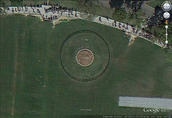
Calculating Area and Perimeter
The ruler too can be used to measure the dimensions of the school playground, a football pitch (see below), a child's garden, the courtyard of Buckingham palace or even The Pentagon, anywhere really! This can be either as a whole class on an interactive display, with everyone calculating areas and perimeters based on the measurements taken or as individuals taking measurements on computers or hand held devices.

Converting Lengths
I've usually done this converting between centimetres, meters and kilometres, but it can also be used to practise converting metric to imperial or vice versa. The example below shows how the length of one side of the Pentagon can be measured and then converted into various different units of measure.

They get into more detail on these items in the full blog entry, which I encourage you to check out.
Posted by mickmel at 7:15 AM
| Comments (1)
« Previous 10 Entries
...
