Map
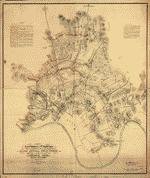
Battlefields in front of Nashville where the United States forces commanded by Major General Geo. H. Thomas defeated and routed the Rebel army under General Hood, December 15th & 16th 1864 /

| Format |
Map |
|---|---|
| Contributors |
Peseux, M. |
| Dates |
1864 |
| Location |
Nashville Tennessee United States |
| Language |
English |
| Subjects |
Civil War History Nashville Nashville (Tenn.) Tennessee United States |
- Title
- Battlefields in front of Nashville where the United States forces commanded by Major General Geo. H. Thomas defeated and routed the Rebel army under General Hood, December 15th & 16th 1864 /
- Description
-
Relief shown by hachures.
-
From "39th Cong., 1st Sess. [1866]-Report of the Chief Engineer, U.S.A."
-
Legend in the upper left corner contains a brief resume of each day's action while the map shows troop positions, roads, railroads, drainage, vegetation, and rural houses. Streets and houses of Nashville are not indicated. Key in upper right corner includes color designation for Rebel and Union works.
-
For a similar copy see LC Civil War maps (2nd ed.), 433 or S170 at G3964.N2S5 1864 .P4.
-
Available also through the Library of Congress web site as raster image.
-
1 map : hand col., 33 x 39 cm.
- Creator
- Peseux, M.
- Created Published
-
[S.l. : s.n.], 1864.
- Subject Headings
-
-
Nashville (Tenn.)--History--Civil War, 1861-1865
-
-
United States--Tennessee--Nashville.
- Notes
-
-
Relief shown by hachures.
-
-
From "39th Cong., 1st Sess. [1866]-Report of the Chief Engineer, U.S.A."
-
-
Legend in the upper left corner contains a brief resume of each day's action while the map shows troop positions, roads, railroads, drainage, vegetation, and rural houses. Streets and houses of Nashville are not indicated. Key in upper right corner includes color designation for Rebel and Union works.
-
-
For a similar copy see LC Civil War maps (2nd ed.), 433 or S170 at G3964.N2S5 1864 .P4.
-
-
Available also through the Library of Congress web site as raster image.
- Medium
-
1 map : hand col., 33 x 39 cm.
- Call Number
-
G3964.N2S5 1864 .P42
- Repository
-
Library of Congress Geography and Map Division Washington, D.C. 20540-4650 dcu
- Digital Id
-
g3964n cw1012000 http://hdl.loc.gov/loc.gmd/g3964n.cw1012000
- Library of Congress Catalog Number
- 2007627469
Rights & Access
The maps in the Map Collections materials were either published prior to 1922, produced by the United States government, or both (see catalogue records that accompany each map for information regarding date of publication and source). The Library of Congress is providing access to these materials for educational and research purposes and is not aware of any U.S. copyright protection (see Title 17 of the United States Code) or any other restrictions in the Map Collection materials.
Note that the written permission of the copyright owners and/or other rights holders (such as publicity and/or privacy rights) is required for distribution, reproduction, or other use of protected items beyond that allowed by fair use or other statutory exemptions. Responsibility for making an independent legal assessment of an item and securing any necessary permissions ultimately rests with persons desiring to use the item.
More about Copyright and other Restrictions
For guidance about compiling full citations consult Citing Primary Sources.
Part of...
-
Civil War Maps
[2281]
-
Military Battles And Campaigns Cartographic Items
[3867]
-
Geography And Maps Division
[60803]
-
American Memory
[1121009]
More maps like this
-
 Battlefields in front of Nashville where the United States forces commanded by Major General Geo. H. Thomas defeated and routed the Rebel army under General ...
Contributor:
Peseux, M.
Site:
American Memory-cultural, Main Catalog
Original Format:
Map
Date:
1864
View catalog record
Battlefields in front of Nashville where the United States forces commanded by Major General Geo. H. Thomas defeated and routed the Rebel army under General ...
Contributor:
Peseux, M.
Site:
American Memory-cultural, Main Catalog
Original Format:
Map
Date:
1864
View catalog record
-
 Battlefields in front of Nashville where the United States forces commanded by Major General Geo. H. Thomas defeated and routed the Rebel army under General ...
Contributor:
Peseux, M.
Site:
American Memory-cultural, Main Catalog
Original Format:
Map
View catalog record
Battlefields in front of Nashville where the United States forces commanded by Major General Geo. H. Thomas defeated and routed the Rebel army under General ...
Contributor:
Peseux, M.
Site:
American Memory-cultural, Main Catalog
Original Format:
Map
View catalog record
-
 Battlefields in front of Nashville where the United States forces commanded by Major General Geo. H. Thomas defeated and routed the Rebel army under General ...
Contributor:
Peseux, M.
Site:
American Memory-cultural, Main Catalog
Original Format:
Map
Date:
1864
View catalog record
Battlefields in front of Nashville where the United States forces commanded by Major General Geo. H. Thomas defeated and routed the Rebel army under General ...
Contributor:
Peseux, M.
Site:
American Memory-cultural, Main Catalog
Original Format:
Map
Date:
1864
View catalog record
-
 Topographical sketch of the environs of Nashville, Tennessee /
Contributor:
Weyss, J. E.
Site:
American Memory-cultural, Main Catalog
Original Format:
Map
Date:
1862
View catalog record
Topographical sketch of the environs of Nashville, Tennessee /
Contributor:
Weyss, J. E.
Site:
American Memory-cultural, Main Catalog
Original Format:
Map
Date:
1862
View catalog record
-
 Nashville--Tenn. and vicinity 1863 /
Contributor:
Blakeslee, G. H.
Site:
American Memory-cultural, Main Catalog
Original Format:
Map
Date:
1863
View catalog record
Nashville--Tenn. and vicinity 1863 /
Contributor:
Blakeslee, G. H.
Site:
American Memory-cultural, Main Catalog
Original Format:
Map
Date:
1863
View catalog record
-
 Topographical map of Nashville, Tenn. /
Contributor:
Willett, James R.
Site:
American Memory-cultural, Main Catalog
Original Format:
Map
View catalog record
Topographical map of Nashville, Tenn. /
Contributor:
Willett, James R.
Site:
American Memory-cultural, Main Catalog
Original Format:
Map
View catalog record
-
 Map of the city of Nashville and vicinity /
Contributor:
Foster, Wilbur F.
Site:
American Memory-cultural, Main Catalog
Original Format:
Map
Date:
1877
View catalog record
Map of the city of Nashville and vicinity /
Contributor:
Foster, Wilbur F.
Site:
American Memory-cultural, Main Catalog
Original Format:
Map
Date:
1877
View catalog record
-
 Map of Nashville, Tennessee.
Site:
American Memory-cultural, Main Catalog
Original Format:
Map
View catalog record
Map of Nashville, Tennessee.
Site:
American Memory-cultural, Main Catalog
Original Format:
Map
View catalog record
-
 Map of Davidson County Tennessee, from actual surveys made by order of the county court of Davidson County, 1871 /
Contributor:
Foster, Wilbur F.
Site:
American Memory-cultural, Main Catalog
Original Format:
Map
Date:
1871
View catalog record
Map of Davidson County Tennessee, from actual surveys made by order of the county court of Davidson County, 1871 /
Contributor:
Foster, Wilbur F.
Site:
American Memory-cultural, Main Catalog
Original Format:
Map
Date:
1871
View catalog record
-
 Map of the battle of Nashville, dec. 15th & 16th 1864
Contributor:
Cowen, James
Site:
American Memory-cultural, Main Catalog
Original Format:
Map
Date:
1887
View catalog record
Map of the battle of Nashville, dec. 15th & 16th 1864
Contributor:
Cowen, James
Site:
American Memory-cultural, Main Catalog
Original Format:
Map
Date:
1887
View catalog record
-
 Tennessee Centennial Exposition, Nashville, Tennessee, 1897.
Site:
American Memory-cultural, Main Catalog
Original Format:
Map
Date:
1896
View catalog record
Tennessee Centennial Exposition, Nashville, Tennessee, 1897.
Site:
American Memory-cultural, Main Catalog
Original Format:
Map
Date:
1896
View catalog record
-
 Topographical sketch of the country adjacent to the turnpike between Nolensville and Chapel Hill, Tenn. /
Contributor:
Weyss, J. E.
Site:
American Memory-cultural, Main Catalog
Original Format:
Map
Date:
1863
View catalog record
Topographical sketch of the country adjacent to the turnpike between Nolensville and Chapel Hill, Tenn. /
Contributor:
Weyss, J. E.
Site:
American Memory-cultural, Main Catalog
Original Format:
Map
Date:
1863
View catalog record
-
 Battle of Missionary Ridge or Chickamauga, Tenn.
Contributor:
Sneden, Robert Knox
Site:
American Memory-cultural
Original Format:
Map
Date:
1861
Battle of Missionary Ridge or Chickamauga, Tenn.
Contributor:
Sneden, Robert Knox
Site:
American Memory-cultural
Original Format:
Map
Date:
1861
-
 Military map of the States of Kentucky and Tennessee, within eleven miles of the 35th parallel of latitude or southern boundary of Tennessee; compiled from ...
Contributor:
Swann, Charles E.
Site:
American Memory-cultural, Main Catalog
Original Format:
Map
Date:
1863
View catalog record
Military map of the States of Kentucky and Tennessee, within eleven miles of the 35th parallel of latitude or southern boundary of Tennessee; compiled from ...
Contributor:
Swann, Charles E.
Site:
American Memory-cultural, Main Catalog
Original Format:
Map
Date:
1863
View catalog record
-
 Grierson's route from La Grange to Baton Rouge. [April 17-May 2, 1863].
Site:
American Memory-cultural, Main Catalog
Original Format:
Map
Date:
1863-05-02
View catalog record
Grierson's route from La Grange to Baton Rouge. [April 17-May 2, 1863].
Site:
American Memory-cultural, Main Catalog
Original Format:
Map
Date:
1863-05-02
View catalog record
-
 The approaches from Washington, to Richmond
Contributor:
Heald, D. A.
Site:
American Memory-cultural, Main Catalog
Original Format:
Map
Date:
1864
View catalog record
The approaches from Washington, to Richmond
Contributor:
Heald, D. A.
Site:
American Memory-cultural, Main Catalog
Original Format:
Map
Date:
1864
View catalog record
You might also like
-

 Early history of Nashville,
Contributor:
Elliott, Lizzie P.
Site:
Main Catalog
Original Format:
Book
Date:
1911
Early history of Nashville,
Contributor:
Elliott, Lizzie P.
Site:
Main Catalog
Original Format:
Book
Date:
1911
-
Old days in Nashville, Tenn.
Contributor:
Thomas, Jane Henry
Site:
Main Catalog
Original Format:
Book
Date:
1897
-
It happened in Nashville, Tennessee;
Contributor:
Beard, W. E.
Site:
Main Catalog
Original Format:
Book
Date:
1912
-
How it was four years among the Rebels /
Contributor:
Morgan, Irby
Site:
American Memory-cultural
Original Format:
Book
Date:
1892
-
 Our march
Contributor:
A High Private, Composer
Site:
Performing Arts Encyclopedia
Original Format:
Music Score
Our march
Contributor:
A High Private, Composer
Site:
Performing Arts Encyclopedia
Original Format:
Music Score
-
The pioneers of Nashville, and of Tennessee ... A historical novel of narrative, about the first settlers of this commonwealth of 1780.
Contributor:
May, Charles
Site:
Main Catalog
Original Format:
Book
Date:
1880