Map
Franklin--Tenn. profield [sic] June 1863 /
Views

More Views

- Title
- Franklin--Tenn. profield [sic] June 1863 /
- Description
-
Sketch map showing troop positions, roads, railroads, streams, and location of the "Cherry tree where was [sic] hung the rebel spies Col. Williams and Lieut. W.G. Peter--June 10, 1863".
-
Relief shown by hachures.
-
Pen-and-ink (brown/red/dark blue).
-
Added in red ink below title: Position of troops at the battle here, added since close of the war--G.H.B.
-
Mounted on paper backing.
-
Watermark: Franklin Mills.
-
Imperfect: Scattered water stains.
-
Includes ill.: Carter House, west of Columbia Pike -- Gin house, east of Columbia Pike -- Bridge over the Harpeth.
-
Two maps pasted on verso on paper backing: [Unattributed ms. map of Lookout Mountain vicinity] -- [Printed map of Lookout Mountain vicinity] / copy by G.H. Blakeslee, Feb. 1893, from a map made by him in 1864.
-
LC Civil War maps (2nd ed.), 417.5
-
Available also through the Library of Congress Web site as a raster image.
-
Gift; Mrs. Geo. W. Volk, Lexington, Neb.; Jan. 1966.
-
1 ms. map : col. ; 39 x 51 cm.
- Creator
- Blakeslee, G. H.
- Created Published
-
1863.
- Subject Headings
-
-
Franklin Region (Tenn.)--History--Civil War, 1861-1865
-
-
Franklin Region (Tenn.)
-
-
Franklin, Battle of, Franklin, Tenn., 1864
-
-
Lookout Mountain Region (Appalachian Mountains)
-
-
Lookout Mountain, Battle of, Tenn., 1863
-
-
United States--Tennessee--Franklin Region.
-
-
United States--Tennessee--Lookout Mountain Region (Appalachian Mountains)
-
-
Lookout Mountain, Battle of, Tenn.
- Notes
-
-
Sketch map showing troop positions, roads, railroads, streams, and location of the "Cherry tree where was [sic] hung the rebel spies Col. Williams and Lieut. W.G. Peter--June 10, 1863".
-
-
Relief shown by hachures.
-
-
Pen-and-ink (brown/red/dark blue).
-
-
Added in red ink below title: Position of troops at the battle here, added since close of the war--G.H.B.
-
-
Mounted on paper backing.
-
-
Watermark: Franklin Mills.
-
-
Imperfect: Scattered water stains.
-
-
Includes ill.: Carter House, west of Columbia Pike -- Gin house, east of Columbia Pike -- Bridge over the Harpeth.
-
-
Two maps pasted on verso on paper backing: [Unattributed ms. map of Lookout Mountain vicinity] -- [Printed map of Lookout Mountain vicinity] / copy by G.H. Blakeslee, Feb. 1893, from a map made by him in 1864.
-
-
LC Civil War maps (2nd ed.), 417.5
-
-
Available also through the Library of Congress Web site as a raster image.
-
-
Gift; Mrs. Geo. W. Volk, Lexington, Neb.; Jan. 1966.
- Medium
-
1 ms. map : col. ; 39 x 51 cm.
- Call Number
-
G3964.F7S5 1863 .B5
- Repository
-
Library of Congress Geography and Map Division Washington, D.C. 20540-4650 USA dcu
- Digital Id
-
g3964f cw0417500r http://hdl.loc.gov/loc.gmd/g3964f.cw0417500r
-
g3964f cw0417500v http://hdl.loc.gov/loc.gmd/g3964f.cw0417500v
- Library of Congress Catalog Number
- 2003630448
Rights & Access
The maps in the Map Collections materials were either published prior to 1922, produced by the United States government, or both (see catalogue records that accompany each map for information regarding date of publication and source). The Library of Congress is providing access to these materials for educational and research purposes and is not aware of any U.S. copyright protection (see Title 17 of the United States Code) or any other restrictions in the Map Collection materials.
Note that the written permission of the copyright owners and/or other rights holders (such as publicity and/or privacy rights) is required for distribution, reproduction, or other use of protected items beyond that allowed by fair use or other statutory exemptions. Responsibility for making an independent legal assessment of an item and securing any necessary permissions ultimately rests with persons desiring to use the item.
More about Copyright and other Restrictions
For guidance about compiling full citations consult Citing Primary Sources.
Part of...
-
Civil War Maps
[2281]
-
Military Battles And Campaigns Cartographic Items
[3867]
-
Geography And Maps Division
[60803]
-
American Memory
[1121009]
More maps like this
-
 Winter quarters 1864 : [vicinity of Lookout Mountain, Tennessee] /
Contributor:
Blakeslee, G. H.
Site:
American Memory-cultural, Main Catalog
Original Format:
Map
Date:
1864
View catalog record
Winter quarters 1864 : [vicinity of Lookout Mountain, Tennessee] /
Contributor:
Blakeslee, G. H.
Site:
American Memory-cultural, Main Catalog
Original Format:
Map
Date:
1864
View catalog record
-
 Battle of Lookout Mountain, Tennessee November 24th, 1863.
Contributor:
Sneden, Robert Knox
Site:
American Memory-cultural
Original Format:
Map
Date:
1861
Battle of Lookout Mountain, Tennessee November 24th, 1863.
Contributor:
Sneden, Robert Knox
Site:
American Memory-cultural
Original Format:
Map
Date:
1861
-
 Plan of the Battle of Lookout Mountain. Fought November 24th-25th, 1863.
Contributor:
Sneden, Robert Knox
Site:
American Memory-cultural
Original Format:
Map
Date:
1863
Plan of the Battle of Lookout Mountain. Fought November 24th-25th, 1863.
Contributor:
Sneden, Robert Knox
Site:
American Memory-cultural
Original Format:
Map
Date:
1863
-
 Nashville--Tenn. and vicinity 1863 /
Contributor:
Blakeslee, G. H.
Site:
American Memory-cultural, Main Catalog
Original Format:
Map
Date:
1863
View catalog record
Nashville--Tenn. and vicinity 1863 /
Contributor:
Blakeslee, G. H.
Site:
American Memory-cultural, Main Catalog
Original Format:
Map
Date:
1863
View catalog record
-
 Chattanooga Tenn. 1863 /
Contributor:
Blakeslee, G. H.
Site:
American Memory-cultural, Main Catalog
Original Format:
Map
Date:
1863
View catalog record
Chattanooga Tenn. 1863 /
Contributor:
Blakeslee, G. H.
Site:
American Memory-cultural, Main Catalog
Original Format:
Map
Date:
1863
View catalog record
-
 Battlefield of Franklin, Tenn. Nov. 3rd 1864
Contributor:
Cowen, James
Site:
American Memory-cultural, Main Catalog
Original Format:
Map
Date:
1887
View catalog record
Battlefield of Franklin, Tenn. Nov. 3rd 1864
Contributor:
Cowen, James
Site:
American Memory-cultural, Main Catalog
Original Format:
Map
Date:
1887
View catalog record
-
 Field works at Franklin, Tenn., occupied by the 23d and 4th corps during engagement of Nov. 30th 1864, Maj. Gen. J. M. Schofield, comdg.
Site:
American Memory-cultural, Main Catalog
Original Format:
Map
Date:
1864
View catalog record
Field works at Franklin, Tenn., occupied by the 23d and 4th corps during engagement of Nov. 30th 1864, Maj. Gen. J. M. Schofield, comdg.
Site:
American Memory-cultural, Main Catalog
Original Format:
Map
Date:
1864
View catalog record
-
 Battlefield in front of Franklin, Tenn. where the United States Forces, consisting of the 4th. & 23d. Corps and the Cavalry Corps M.D.M., all under ...
Contributor:
Merrill, W. E.
Site:
American Memory-cultural, Main Catalog
Original Format:
Map
Date:
1874
View catalog record
Battlefield in front of Franklin, Tenn. where the United States Forces, consisting of the 4th. & 23d. Corps and the Cavalry Corps M.D.M., all under ...
Contributor:
Merrill, W. E.
Site:
American Memory-cultural, Main Catalog
Original Format:
Map
Date:
1874
View catalog record
-
 Battlefield in front of Franklin, Tenn. where the United States forces, consisting of the 4th & 23rd Corps and the Cavalry Corps M.D.M., all under ...
Contributor:
Merrill, W. E.
Site:
American Memory-cultural, Main Catalog
Original Format:
Map
Date:
1874
View catalog record
Battlefield in front of Franklin, Tenn. where the United States forces, consisting of the 4th & 23rd Corps and the Cavalry Corps M.D.M., all under ...
Contributor:
Merrill, W. E.
Site:
American Memory-cultural, Main Catalog
Original Format:
Map
Date:
1874
View catalog record
-
 [Battlefield in front of Franklin, Tenn., November 30th, 1864].
Contributor:
Merrill, W. E.
Site:
American Memory-cultural, Main Catalog
Original Format:
Map
Date:
1864
View catalog record
[Battlefield in front of Franklin, Tenn., November 30th, 1864].
Contributor:
Merrill, W. E.
Site:
American Memory-cultural, Main Catalog
Original Format:
Map
Date:
1864
View catalog record
-
 Middle Tennessee /
Contributor:
Blakeslee, G. H.
Site:
American Memory-cultural, Main Catalog
Original Format:
Map
Date:
1863
View catalog record
Middle Tennessee /
Contributor:
Blakeslee, G. H.
Site:
American Memory-cultural, Main Catalog
Original Format:
Map
Date:
1863
View catalog record
-
 From Mitchelsville [sic] to Gallatin--Sumner Co., Tenn., 1862 /
Contributor:
Blakeslee, G. H.
Site:
American Memory-cultural, Main Catalog
Original Format:
Map
Date:
1862
View catalog record
From Mitchelsville [sic] to Gallatin--Sumner Co., Tenn., 1862 /
Contributor:
Blakeslee, G. H.
Site:
American Memory-cultural, Main Catalog
Original Format:
Map
Date:
1862
View catalog record
-
 Map of the battle of Nashville, dec. 15th & 16th 1864
Contributor:
Cowen, James
Site:
American Memory-cultural, Main Catalog
Original Format:
Map
Date:
1887
View catalog record
Map of the battle of Nashville, dec. 15th & 16th 1864
Contributor:
Cowen, James
Site:
American Memory-cultural, Main Catalog
Original Format:
Map
Date:
1887
View catalog record
-
 Battlefields in front of Nashville where the United States forces commanded by Major General Geo. H. Thomas defeated and routed the Rebel army under General ...
Contributor:
Peseux, M.
Site:
American Memory-cultural, Main Catalog
Original Format:
Map
View catalog record
Battlefields in front of Nashville where the United States forces commanded by Major General Geo. H. Thomas defeated and routed the Rebel army under General ...
Contributor:
Peseux, M.
Site:
American Memory-cultural, Main Catalog
Original Format:
Map
View catalog record
-
 Battlefields in front of Nashville where the United States forces commanded by Major General Geo. H. Thomas defeated and routed the Rebel army under General ...
Contributor:
Peseux, M.
Site:
American Memory-cultural, Main Catalog
Original Format:
Map
Date:
1864
View catalog record
Battlefields in front of Nashville where the United States forces commanded by Major General Geo. H. Thomas defeated and routed the Rebel army under General ...
Contributor:
Peseux, M.
Site:
American Memory-cultural, Main Catalog
Original Format:
Map
Date:
1864
View catalog record
You might also like
-
 Point Lookout, Lookout Mt., Tenn.
Contributor:
Detroit Publishing Co
Site:
Prints & Photographs
Original Format:
Photo, Print, Drawing
Date:
1907
Point Lookout, Lookout Mt., Tenn.
Contributor:
Detroit Publishing Co
Site:
Prints & Photographs
Original Format:
Photo, Print, Drawing
Date:
1907
-
 Towards Chattanooga from Lookout Mt., Tenn.
Contributor:
Jackson, William Henry, Detroit Publishing Co
Site:
Prints & Photographs
Original Format:
Photo, Print, Drawing
Date:
1900
Towards Chattanooga from Lookout Mt., Tenn.
Contributor:
Jackson, William Henry, Detroit Publishing Co
Site:
Prints & Photographs
Original Format:
Photo, Print, Drawing
Date:
1900
-
 [New York memorial, Lookout Mountain, Chattanooga, Tenn.]
Contributor:
Detroit Publishing Co
Site:
Prints & Photographs
Original Format:
Photo, Print, Drawing
Date:
1905
[New York memorial, Lookout Mountain, Chattanooga, Tenn.]
Contributor:
Detroit Publishing Co
Site:
Prints & Photographs
Original Format:
Photo, Print, Drawing
Date:
1905
-
 The Craven House and Point Lookout, Lookout Mountain
Contributor:
Jackson, William Henry, Detroit Publishing Co
Site:
Prints & Photographs
Original Format:
Photo, Print, Drawing
Date:
1902
The Craven House and Point Lookout, Lookout Mountain
Contributor:
Jackson, William Henry, Detroit Publishing Co
Site:
Prints & Photographs
Original Format:
Photo, Print, Drawing
Date:
1902
-
 Lookout. Mt. from the west. Captured No 23 1863 by Maj Gen Hooker & the 11 and 12 A[G?]
Contributor:
Blakeslee, G. H.
Site:
Prints & Photographs, Main Catalog
Original Format:
Photo, Print, Drawing
Date:
1864
View catalog record
Lookout. Mt. from the west. Captured No 23 1863 by Maj Gen Hooker & the 11 and 12 A[G?]
Contributor:
Blakeslee, G. H.
Site:
Prints & Photographs, Main Catalog
Original Format:
Photo, Print, Drawing
Date:
1864
View catalog record
-
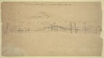 Diagram of an historical painting of the Battle of "Lookout Mountain"
Site:
Prints & Photographs, Main Catalog
Original Format:
Photo, Print, Drawing
Date:
1863
View catalog record
Diagram of an historical painting of the Battle of "Lookout Mountain"
Site:
Prints & Photographs, Main Catalog
Original Format:
Photo, Print, Drawing
Date:
1863
View catalog record