Map
Johnson's new illustrated (steel plate) family atlas, with descriptions, geographical, statistical, and historical /
Views

| Format |
Map |
|---|---|
| Contributors |
Johnson, A. J. |
| Dates |
1862 |
| Location |
Earth |
| Language |
English |
| Subjects |
Atlases Earth |
- Title
- Johnson's new illustrated (steel plate) family atlas, with descriptions, geographical, statistical, and historical /
- Description
-
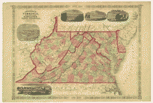
Relief shown by hachures.
-
LC Civil War maps (2nd ed.), 13.96
-
Phillips, 837
-
Available also through the Library of Congress Web site as a raster image.
-
Johnson's new military map of the United States showing forts, military posts &c. with enlarged plans of southern harbors; Map 20-21, listed in LC Civil War maps (2nd ed.), 13.96.
-
LC copy imperfect: Brittle, with losses and repairs on edges. Half title and title page detached. DLC
-
1 atlas (1 v. (various pagings)) : ill. (some col., some hand col.), hand col. maps ; 47 cm.
- Creator
- Johnson, A. J.
- Created Published
-
New York : Johnson and Ward, 1862.
- Subject Headings
-
-
Atlases.
-
-
Earth.
- Notes
-
-
Relief shown by hachures.
-
-
LC Civil War maps (2nd ed.), 13.96
-
-
Phillips, 837
-
-
Available also through the Library of Congress Web site as a raster image.
-
-
Johnson's new military map of the United States showing forts, military posts &c. with enlarged plans of southern harbors; Map 20-21, listed in LC Civil War maps (2nd ed.), 13.96.
-
-
LC copy imperfect: Brittle, with losses and repairs on edges. Half title and title page detached. DLC
- Medium
-
1 atlas (1 v. (various pagings)) : ill. (some col., some hand col.), hand col. maps ; 47 cm.
- Call Number
-
G1019 .J5 1862
-
G1019 .J5 1862 Copy 2 Two maps of Toldeo, Ohio, tipped in between half title and title page. First map: Toledo, O. Published by Penfield & Alexander. Second map: Map of Toledo, Lucas Co., Ohio / from special surveys and official records by J.B. Marston. Toldeo, O[hio] : Published by T.J. Brown, Eager & Co., 1874. Atlas brittle, with losses and repairs on edges. Plates 4-5 & 6-7 detached.
- Repository
-
Library of Congress Geography and Map Division Washington, D.C. 20540-4650 USA dcu
- Digital Id
-
g3200m gcw0013960 http://hdl.loc.gov/loc.gmd/g3200m.gcw0013960
- Library of Congress Catalog Number
- 2006458033
Rights & Access
The maps in the Map Collections materials were either published prior to 1922, produced by the United States government, or both (see catalogue records that accompany each map for information regarding date of publication and source). The Library of Congress is providing access to these materials for educational and research purposes and is not aware of any U.S. copyright protection (see Title 17 of the United States Code) or any other restrictions in the Map Collection materials.
Note that the written permission of the copyright owners and/or other rights holders (such as publicity and/or privacy rights) is required for distribution, reproduction, or other use of protected items beyond that allowed by fair use or other statutory exemptions. Responsibility for making an independent legal assessment of an item and securing any necessary permissions ultimately rests with persons desiring to use the item.
More about Copyright and other Restrictions
For guidance about compiling full citations consult Citing Primary Sources.
Part of...
-
Civil War Maps
[2281]
-
Military Battles And Campaigns Cartographic Items
[3867]
-
Geography And Maps Division
[60803]
-
American Memory
[1121009]
More maps like this
-
 Johnson's new illustrated (steel plate) family atlas, with descriptions, geographical, statistical, and historical /
Contributor:
Johnson, A. J.
Site:
American Memory-cultural, Main Catalog
Original Format:
Map
Date:
1863
View catalog record
Johnson's new illustrated (steel plate) family atlas, with descriptions, geographical, statistical, and historical /
Contributor:
Johnson, A. J.
Site:
American Memory-cultural, Main Catalog
Original Format:
Map
Date:
1863
View catalog record
-
 Johnson's new illustrated (steel plate) family atlas, with descriptions, geographical, statistical, and historical /
Contributor:
Johnson, A. J.
Site:
American Memory-cultural, Main Catalog
Original Format:
Map
Date:
1862
View catalog record
Johnson's new illustrated (steel plate) family atlas, with descriptions, geographical, statistical, and historical /
Contributor:
Johnson, A. J.
Site:
American Memory-cultural, Main Catalog
Original Format:
Map
Date:
1862
View catalog record
-
 A new universal atlas, containing maps of the various empires, kingdoms, states and republics of the world : with a special map of each of ...
Contributor:
Tanner, Henry Schenck
Site:
American Memory-cultural, Main Catalog
Original Format:
Map
Date:
1844
View catalog record
A new universal atlas, containing maps of the various empires, kingdoms, states and republics of the world : with a special map of each of ...
Contributor:
Tanner, Henry Schenck
Site:
American Memory-cultural, Main Catalog
Original Format:
Map
Date:
1844
View catalog record
-
 A new universal atlas containing maps of the various empires, kingdoms, states and republics of the world : with a special map of each of ...
Contributor:
Mitchell, S. Augustus
Site:
American Memory-cultural, Main Catalog
Original Format:
Map
Date:
1849
View catalog record
A new universal atlas containing maps of the various empires, kingdoms, states and republics of the world : with a special map of each of ...
Contributor:
Mitchell, S. Augustus
Site:
American Memory-cultural, Main Catalog
Original Format:
Map
Date:
1849
View catalog record
-
 A new and elegent general atlas, containing maps of each of the United States.
Contributor:
Lucas, Fielding
Site:
American Memory-cultural, Main Catalog
Original Format:
Map
Date:
1817
View catalog record
A new and elegent general atlas, containing maps of each of the United States.
Contributor:
Lucas, Fielding
Site:
American Memory-cultural, Main Catalog
Original Format:
Map
Date:
1817
View catalog record
-
 Mapamondi.
Contributor:
Cresques, Abraham
Site:
American Memory-cultural, Main Catalog
Original Format:
Map
Date:
1959
View catalog record
Mapamondi.
Contributor:
Cresques, Abraham
Site:
American Memory-cultural, Main Catalog
Original Format:
Map
Date:
1959
View catalog record
-
 Johnson's new railroad and township copper-plate map of Illinois, Iowa, & Missouri, from the latest and best authorities.
Contributor:
Johnson, A. J.
Site:
American Memory-cultural, Main Catalog
Original Format:
Map
Date:
1859
View catalog record
Johnson's new railroad and township copper-plate map of Illinois, Iowa, & Missouri, from the latest and best authorities.
Contributor:
Johnson, A. J.
Site:
American Memory-cultural, Main Catalog
Original Format:
Map
Date:
1859
View catalog record
-
 Johnson's map of the vicinity of Richmond, and Peninsular Campaign in Virginia : showing also the interesting localities along the James, Chickahominy and York rivers ...
Contributor:
Johnson, A. J.
Site:
American Memory-cultural, Main Catalog
Original Format:
Map
Date:
1870
View catalog record
Johnson's map of the vicinity of Richmond, and Peninsular Campaign in Virginia : showing also the interesting localities along the James, Chickahominy and York rivers ...
Contributor:
Johnson, A. J.
Site:
American Memory-cultural, Main Catalog
Original Format:
Map
Date:
1870
View catalog record
-
 Johnson's map of the vicinity of Richmond, and Peninsular Campaign in Virginia : showing also the interesting localities along the James, Chickahominy and York rivers ...
Contributor:
Johnson, A. J.
Site:
American Memory-cultural, Main Catalog
Original Format:
Map
Date:
1869
View catalog record
Johnson's map of the vicinity of Richmond, and Peninsular Campaign in Virginia : showing also the interesting localities along the James, Chickahominy and York rivers ...
Contributor:
Johnson, A. J.
Site:
American Memory-cultural, Main Catalog
Original Format:
Map
Date:
1869
View catalog record
-
 Johnson's map of the vicinity of Richmond and Peninsular Campaign in Virginia : showing also the interesting localities along the James, Chickahominy, and York Rivers ...
Contributor:
Johnson, A. J.
Site:
American Memory-cultural
Original Format:
Map
Date:
1868
Johnson's map of the vicinity of Richmond and Peninsular Campaign in Virginia : showing also the interesting localities along the James, Chickahominy, and York Rivers ...
Contributor:
Johnson, A. J.
Site:
American Memory-cultural
Original Format:
Map
Date:
1868
-
 Johnson's map of the vicinity of Richmond and Peninsular Campaign in Virginia : showing also the interesting localities along the James, Chickahominy, and York Rivers ...
Contributor:
Johnson, A. J.
Site:
American Memory-cultural
Original Format:
Map
Date:
1864
Johnson's map of the vicinity of Richmond and Peninsular Campaign in Virginia : showing also the interesting localities along the James, Chickahominy, and York Rivers ...
Contributor:
Johnson, A. J.
Site:
American Memory-cultural
Original Format:
Map
Date:
1864
-
 Johnson's Virginia, Delaware, Maryland & West Virginia
Contributor:
Johnson, A. J.
Site:
American Memory-cultural
Original Format:
Map
Date:
1864
Johnson's Virginia, Delaware, Maryland & West Virginia
Contributor:
Johnson, A. J.
Site:
American Memory-cultural
Original Format:
Map
Date:
1864
-
 Johnson's Virginia, Delaware, Maryland & West Virginia.
Contributor:
Johnson, A. J.
Site:
American Memory-cultural
Original Format:
Map
Date:
1864
Johnson's Virginia, Delaware, Maryland & West Virginia.
Contributor:
Johnson, A. J.
Site:
American Memory-cultural
Original Format:
Map
Date:
1864
-
 Johnson's Virginia, Delaware and Maryland.
Contributor:
Johnson, A. J.
Site:
American Memory-cultural
Original Format:
Map
Date:
1864
Johnson's Virginia, Delaware and Maryland.
Contributor:
Johnson, A. J.
Site:
American Memory-cultural
Original Format:
Map
Date:
1864
-
 Johnson's map of Indiana showing the rail roads and townships compiled from the latest & best authorities.
Contributor:
Johnson, A. J.
Site:
American Memory-cultural, Main Catalog
Original Format:
Map
Date:
1858
View catalog record
Johnson's map of Indiana showing the rail roads and townships compiled from the latest & best authorities.
Contributor:
Johnson, A. J.
Site:
American Memory-cultural, Main Catalog
Original Format:
Map
Date:
1858
View catalog record
-
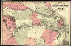 Johnson's map of the vicinity of Richmond, and Peninsular Campaign in Virginia : showing also the interesting localities along the James, Chickahominy and York rivers ...
Contributor:
Johnson, A. J.
Site:
American Memory-cultural, Main Catalog
Original Format:
Map
Date:
1862
View catalog record
Johnson's map of the vicinity of Richmond, and Peninsular Campaign in Virginia : showing also the interesting localities along the James, Chickahominy and York rivers ...
Contributor:
Johnson, A. J.
Site:
American Memory-cultural, Main Catalog
Original Format:
Map
Date:
1862
View catalog record
You might also like
-
-
-
-

 The Earth : its birth and growth /
Contributor:
Ojima, Minoru
Site:
Main Catalog
Original Format:
Book
Date:
2012
The Earth : its birth and growth /
Contributor:
Ojima, Minoru
Site:
Main Catalog
Original Format:
Book
Date:
2012
-
Annihilation or renewal? : the meaning and function of new creation in the book of Revelation /
Contributor:
Stephens, Mark B.
Site:
Main Catalog
Original Format:
Book
Date:
2011
-

