Map
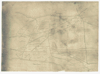
Map of the country between the York and James Rivers in 1862 and 1863 : showing the names of the owners of the divisions of land at that time.
| Format |
Map |
|---|---|
| Contributors |
Thayer, Eli |
| Dates |
1863 |
| Location |
United States Virginia Virginia Peninsula |
| Language |
English |
| Subjects |
Civil War History United States Virginia Virginia Peninsula Virginia Peninsula (Va.) |
- Title
- Map of the country between the York and James Rivers in 1862 and 1863 : showing the names of the owners of the divisions of land at that time.
- Description
-
"From a survey made for Hon. Eli Thayer of Massachusetts, who fixed at this point the site of the city he intended to build in connection with his plan for the free-labor colonization of Virginia. Mr. Thayer passed the union lines twice in 1862-3, receiving written authority from Secretary Seward, and with the aid of a surveyor was able to complete this map."--verso.
-
Show rivers, railroads, roads, towns and houses with names of the owners.
-
Sun print.
-
This item is in the Map Collection of the Library of Virginia; please contact the Library's Archives Research Services department for more information.
-
Title from verso of map.
-
Swem, E.G. Maps relating to Virginia, 1041
-
Available also through the Library of Congress web site as raster image.
-
c. 1, May 1904, Franklin P. Rice, gift; c. 2 1974 photocopy, LVA; c. 3 photocopy, LVA; Feb. 2004, Map Cataloging Team.
-
Civil War project no.: lva00180.
-
Copy 1: Conservation: Etherington Conservation Center, Dec. 2003.
-
Copy 1: map accession no. 5237X; c. 2 map accession no. 4172 (1974), (negative photostat, LVA, Oct. 1974, 30 x 41 cm.); c. 3 (positive photocopy, LVA, 31 x 42 cm.)
-
Digital image available: 11.75 x 16 in.
-
Previously filed as: 755.4 S8 1863.
-
1 map : photocopy, mounted on paper ; 29 x 41 cm.
- Creator
- Thayer, Eli, 1819-1899.
- Created Published
-
[S.l. : s.n., 1863?]
- Subject Headings
-
-
Virginia Peninsula (Va.)--History--Civil War, 1861-1865
-
-
United States--Virginia--Virginia Peninsula.
- Notes
-
-
"From a survey made for Hon. Eli Thayer of Massachusetts, who fixed at this point the site of the city he intended to build in connection with his plan for the free-labor colonization of Virginia. Mr. Thayer passed the union lines twice in 1862-3, receiving written authority from Secretary Seward, and with the aid of a surveyor was able to complete this map."--verso.
-
-
Show rivers, railroads, roads, towns and houses with names of the owners.
-
-
Sun print.
-
-
This item is in the Map Collection of the Library of Virginia; please contact the Library's Archives Research Services department for more information.
-
-
Title from verso of map.
-
-
Swem, E.G. Maps relating to Virginia, 1041
-
-
Available also through the Library of Congress web site as raster image.
-
-
c. 1, May 1904, Franklin P. Rice, gift; c. 2 1974 photocopy, LVA; c. 3 photocopy, LVA; Feb. 2004, Map Cataloging Team.
-
-
Civil War project no.: lva00180.
-
-
Copy 1: Conservation: Etherington Conservation Center, Dec. 2003.
-
-
Copy 1: map accession no. 5237X; c. 2 map accession no. 4172 (1974), (negative photostat, LVA, Oct. 1974, 30 x 41 cm.); c. 3 (positive photocopy, LVA, 31 x 42 cm.)
-
-
Digital image available: 11.75 x 16 in.
-
-
Previously filed as: 755.4 S8 1863.
- Medium
-
1 map : photocopy, mounted on paper ; 29 x 41 cm.
- Repository
-
Library of Virginia Richmond, VA 23219-8000 USA vau For copies contact: Archives Research Services.
- Digital Id
-
glva01 lva00180 http://hdl.loc.gov/loc.ndlpcoop/glva01.lva00180
Rights & Access
The maps in the Map Collections materials were either published prior to 1922, produced by the United States government, or both (see catalogue records that accompany each map for information regarding date of publication and source). The Library of Congress is providing access to these materials for educational and research purposes and is not aware of any U.S. copyright protection (see Title 17 of the United States Code) or any other restrictions in the Map Collection materials.
Note that the written permission of the copyright owners and/or other rights holders (such as publicity and/or privacy rights) is required for distribution, reproduction, or other use of protected items beyond that allowed by fair use or other statutory exemptions. Responsibility for making an independent legal assessment of an item and securing any necessary permissions ultimately rests with persons desiring to use the item.
More about Copyright and other Restrictions
For guidance about compiling full citations consult Citing Primary Sources.
Part of...
-
Civil War Maps
[2281]
-
American Memory
[1121009]
More maps like this
-
 The battle fields and military positions in the Virginian Peninsula, from surveys supplied by officers of the army
Contributor:
Heald, D. A.
Site:
American Memory-cultural, Main Catalog
Original Format:
Map
Date:
1862
View catalog record
The battle fields and military positions in the Virginian Peninsula, from surveys supplied by officers of the army
Contributor:
Heald, D. A.
Site:
American Memory-cultural, Main Catalog
Original Format:
Map
Date:
1862
View catalog record
-
 Plan of the Rebel position at Howard's Bridge, April 4th 1862.
Contributor:
Sneden, Robert Knox
Site:
American Memory-cultural
Original Format:
Map
Date:
1862
Plan of the Rebel position at Howard's Bridge, April 4th 1862.
Contributor:
Sneden, Robert Knox
Site:
American Memory-cultural
Original Format:
Map
Date:
1862
-
 Map of the Peninsula of Virginia : showing route of McClellan's Army toward Richmond [illegible].
Contributor:
Sneden, Robert Knox
Site:
American Memory-cultural
Original Format:
Map
Date:
1862
Map of the Peninsula of Virginia : showing route of McClellan's Army toward Richmond [illegible].
Contributor:
Sneden, Robert Knox
Site:
American Memory-cultural
Original Format:
Map
Date:
1862
-
 The Rebel works at Howard's Bridge Virginia April 4th 1862.
Contributor:
Sneden, Robert Knox
Site:
American Memory-cultural
Original Format:
Map
Date:
1862
The Rebel works at Howard's Bridge Virginia April 4th 1862.
Contributor:
Sneden, Robert Knox
Site:
American Memory-cultural
Original Format:
Map
Date:
1862
-
 Map of the Lower Peninsula of Virginia, April 1862.
Contributor:
Sneden, Robert Knox
Site:
American Memory-cultural
Original Format:
Map
Date:
1862
Map of the Lower Peninsula of Virginia, April 1862.
Contributor:
Sneden, Robert Knox
Site:
American Memory-cultural
Original Format:
Map
Date:
1862
-
 The assault on the "Red Battery," April 25th, 1862 Yorktown, Va.
Contributor:
Sneden, Robert Knox
Site:
American Memory-cultural
Original Format:
Map
Date:
1862
The assault on the "Red Battery," April 25th, 1862 Yorktown, Va.
Contributor:
Sneden, Robert Knox
Site:
American Memory-cultural
Original Format:
Map
Date:
1862
-
 Extract from Fort Monroe, Norfolk, Suffolk, and Yorktown, with their connections and surroundings for military purposes /
Contributor:
Cram, Thomas Jefferson
Site:
American Memory-cultural, Main Catalog
Original Format:
Map
Date:
1862
View catalog record
Extract from Fort Monroe, Norfolk, Suffolk, and Yorktown, with their connections and surroundings for military purposes /
Contributor:
Cram, Thomas Jefferson
Site:
American Memory-cultural, Main Catalog
Original Format:
Map
Date:
1862
View catalog record
-
 Johnson's map of the vicinity of Richmond, and Peninsular Campaign in Virginia : showing also the interesting localities along the James, Chickahominy and York rivers ...
Contributor:
Johnson, A. J.
Site:
American Memory-cultural, Main Catalog
Original Format:
Map
Date:
1870
View catalog record
Johnson's map of the vicinity of Richmond, and Peninsular Campaign in Virginia : showing also the interesting localities along the James, Chickahominy and York rivers ...
Contributor:
Johnson, A. J.
Site:
American Memory-cultural, Main Catalog
Original Format:
Map
Date:
1870
View catalog record
-
 Map of the vicinity of Richmond and part of the Peninsula /
Contributor:
Campbell, Albert H.
Site:
American Memory-cultural, Main Catalog
Original Format:
Map
Date:
1864
View catalog record
Map of the vicinity of Richmond and part of the Peninsula /
Contributor:
Campbell, Albert H.
Site:
American Memory-cultural, Main Catalog
Original Format:
Map
Date:
1864
View catalog record
-
 Johnson's map of the vicinity of Richmond, and Peninsular Campaign in Virginia : showing also the interesting localities along the James, Chickahominy and York rivers ...
Contributor:
Johnson, A. J.
Site:
American Memory-cultural, Main Catalog
Original Format:
Map
Date:
1869
View catalog record
Johnson's map of the vicinity of Richmond, and Peninsular Campaign in Virginia : showing also the interesting localities along the James, Chickahominy and York rivers ...
Contributor:
Johnson, A. J.
Site:
American Memory-cultural, Main Catalog
Original Format:
Map
Date:
1869
View catalog record
-
 Map of the vicinity of Richmond and part of the Peninsula /
Contributor:
Campbell, Albert H.
Site:
American Memory-cultural, Main Catalog
Original Format:
Map
Date:
1864
View catalog record
Map of the vicinity of Richmond and part of the Peninsula /
Contributor:
Campbell, Albert H.
Site:
American Memory-cultural, Main Catalog
Original Format:
Map
Date:
1864
View catalog record
-
 [Map of the part of Virginia lying between the York and James rivers : showing battles and routes of Union forces 1861-62].
Site:
American Memory-cultural, Main Catalog
Original Format:
Map
Date:
1962
View catalog record
[Map of the part of Virginia lying between the York and James rivers : showing battles and routes of Union forces 1861-62].
Site:
American Memory-cultural, Main Catalog
Original Format:
Map
Date:
1962
View catalog record
-
 Map of the vicinity of Richmond, and part of the peninsula /
Contributor:
Gilmer, Jeremy Francis
Site:
American Memory-cultural
Original Format:
Map
Date:
1864
Map of the vicinity of Richmond, and part of the peninsula /
Contributor:
Gilmer, Jeremy Francis
Site:
American Memory-cultural
Original Format:
Map
Date:
1864
-
 Map of the vicinity of Richmond and part of the Peninsula /
Contributor:
Campbell, Albert H.
Site:
American Memory-cultural
Original Format:
Map
Date:
1864
Map of the vicinity of Richmond and part of the Peninsula /
Contributor:
Campbell, Albert H.
Site:
American Memory-cultural
Original Format:
Map
Date:
1864
-
 Map of the vicinity of Richmond, Va. and part of the Peninsula /
Contributor:
Campbell, Albert H.
Site:
American Memory-cultural
Original Format:
Map
Date:
1920
Map of the vicinity of Richmond, Va. and part of the Peninsula /
Contributor:
Campbell, Albert H.
Site:
American Memory-cultural
Original Format:
Map
Date:
1920
-
 Official map of the Union works in front of Yorktown, Va.
Contributor:
Sneden, Robert Knox
Site:
American Memory-cultural
Original Format:
Map
Date:
1862
Official map of the Union works in front of Yorktown, Va.
Contributor:
Sneden, Robert Knox
Site:
American Memory-cultural
Original Format:
Map
Date:
1862
You might also like
-
-
-
-

 Fortifications on Bermuda Hundred's Line near Point of Rocks, Va.
Site:
Main Catalog
Original Format:
Photo, Print, Drawing
Date:
1861
Fortifications on Bermuda Hundred's Line near Point of Rocks, Va.
Site:
Main Catalog
Original Format:
Photo, Print, Drawing
Date:
1861
-
Palmer's field, on Orange Turnpike, Confederate entrenchments at edge of woods
Site:
Main Catalog
Original Format:
Photo, Print, Drawing
Date:
1861
-
 During the war and after the war.
Contributor:
[Scott, John]
Site:
Main Catalog
Original Format:
Book
Date:
1896
During the war and after the war.
Contributor:
[Scott, John]
Site:
Main Catalog
Original Format:
Book
Date:
1896