Map
Map of the vicinity of Richmond and part of the Peninsula /
Views

More Views

| Format |
Map |
|---|---|
| Contributors |
Campbell, Albert H. |
| Dates |
1864 |
| Location |
Richmond Region United States Virginia Virginia Peninsula |
| Language |
English |
| Subjects |
Civil War History Richmond Region Richmond Region (Va.) United States Virginia Virginia Peninsula Virginia Peninsula (Va.) |
- Title
- Map of the vicinity of Richmond and part of the Peninsula /
- Description
-
Sun print.
-
Photocopy (positive).
-
Relief shown by hachures.
-
LC Civil War maps (2nd ed.), 625
-
Description derived from published bibliography.
-
Available also through the Library of Congress Web site as a raster image.
-
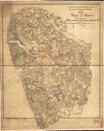
Map of the Virginia Peninsula from Round Squirrel Church,15 miles northwest of Richmond, to Williamsburg, 44 miles southeast of Richmond.
-
Hand colored photocopy showing roads in brown, principal rivers in blue, fortifications, railroads,street pattern of Richmond towns, houses, names of residents, bridges, fords, and ferries.
-
LC Copy 1: Roads marked and highlighted in red. DLC
-
LC Copy 1: Signed in ms. on verso: The property of T. Sewell Ball, Pikesville, Baltimore Co., Maryland. DLC
-
1 map : photocopy, hand col. ; 94 x 102 cm.
- Creator
- Campbell, Albert H.
- Created Published
-
[S.l. : s.n.] , 1864
- Subject Headings
-
-
Richmond Region (Va.)--History--Civil War, 1861-1865
-
-
Virginia Peninsula (Va.)--History--Civil War, 1861-1865
-
-
United States--Virginia--Richmond Region.
-
-
United States--Virginia--Virginia Peninsula.
- Notes
-
-
Sun print.
-
-
Photocopy (positive).
-
-
Relief shown by hachures.
-
-
LC Civil War maps (2nd ed.), 625
-
-
Description derived from published bibliography.
-
-
Available also through the Library of Congress Web site as a raster image.
-
-
Map of the Virginia Peninsula from Round Squirrel Church,15 miles northwest of Richmond, to Williamsburg, 44 miles southeast of Richmond.
-
-
Hand colored photocopy showing roads in brown, principal rivers in blue, fortifications, railroads,street pattern of Richmond towns, houses, names of residents, bridges, fords, and ferries.
-
-
LC Copy 1: Roads marked and highlighted in red. DLC
-
-
LC Copy 1: Signed in ms. on verso: The property of T. Sewell Ball, Pikesville, Baltimore Co., Maryland. DLC
- Medium
-
1 map : photocopy, hand col. ; 94 x 102 cm.
- Call Number
-
G3884.R5S5 1864 .C31
-
G3884.R5S5 1864 .C31 CW 625 Copy 2 annotated in red ink, some areas highlighted in green. Annotated in black ink in lower left corner: "Feb. 18th, 1870. Apricots in bloom at Shirley." This map was acquired by the Library of Congress in 1948 with the purchase of the papers and maps of Jedediah Hotchkiss.
- Repository
-
Library of Congress Geography and Map Division Washington, D.C. 20540-4650 USA dcu
- Digital Id
-
g3884r cw0625000a http://hdl.loc.gov/loc.gmd/g3884r.cw0625000a
-
g3884r cw0625000b http://hdl.loc.gov/loc.gmd/g3884r.cw0625000b
- Library of Congress Catalog Number
- 2006629757
Rights & Access
The maps in the Map Collections materials were either published prior to 1922, produced by the United States government, or both (see catalogue records that accompany each map for information regarding date of publication and source). The Library of Congress is providing access to these materials for educational and research purposes and is not aware of any U.S. copyright protection (see Title 17 of the United States Code) or any other restrictions in the Map Collection materials.
Note that the written permission of the copyright owners and/or other rights holders (such as publicity and/or privacy rights) is required for distribution, reproduction, or other use of protected items beyond that allowed by fair use or other statutory exemptions. Responsibility for making an independent legal assessment of an item and securing any necessary permissions ultimately rests with persons desiring to use the item.
More about Copyright and other Restrictions
For guidance about compiling full citations consult Citing Primary Sources.
Part of...
-
Civil War Maps
[2281]
-
Military Battles And Campaigns Cartographic Items
[3867]
-
Geography And Maps Division
[60803]
-
American Memory
[1121009]
More maps like this
-
 Map of the vicinity of Richmond and part of the Peninsula /
Contributor:
Campbell, Albert H.
Site:
American Memory-cultural, Main Catalog
Original Format:
Map
Date:
1864
View catalog record
Map of the vicinity of Richmond and part of the Peninsula /
Contributor:
Campbell, Albert H.
Site:
American Memory-cultural, Main Catalog
Original Format:
Map
Date:
1864
View catalog record
-
 Map of the vicinity of Richmond and part of the Peninsula /
Contributor:
Campbell, Albert H.
Site:
American Memory-cultural
Original Format:
Map
Date:
1864
Map of the vicinity of Richmond and part of the Peninsula /
Contributor:
Campbell, Albert H.
Site:
American Memory-cultural
Original Format:
Map
Date:
1864
-
 Map of the vicinity of Richmond, Va. and part of the Peninsula /
Contributor:
Campbell, Albert H.
Site:
American Memory-cultural
Original Format:
Map
Date:
1920
Map of the vicinity of Richmond, Va. and part of the Peninsula /
Contributor:
Campbell, Albert H.
Site:
American Memory-cultural
Original Format:
Map
Date:
1920
-
 Johnson's map of the vicinity of Richmond, and Peninsular Campaign in Virginia : showing also the interesting localities along the James, Chickahominy and York rivers ...
Contributor:
Johnson, A. J.
Site:
American Memory-cultural, Main Catalog
Original Format:
Map
Date:
1870
View catalog record
Johnson's map of the vicinity of Richmond, and Peninsular Campaign in Virginia : showing also the interesting localities along the James, Chickahominy and York rivers ...
Contributor:
Johnson, A. J.
Site:
American Memory-cultural, Main Catalog
Original Format:
Map
Date:
1870
View catalog record
-
 Johnson's map of the vicinity of Richmond, and Peninsular Campaign in Virginia : showing also the interesting localities along the James, Chickahominy and York rivers ...
Contributor:
Johnson, A. J.
Site:
American Memory-cultural, Main Catalog
Original Format:
Map
Date:
1869
View catalog record
Johnson's map of the vicinity of Richmond, and Peninsular Campaign in Virginia : showing also the interesting localities along the James, Chickahominy and York rivers ...
Contributor:
Johnson, A. J.
Site:
American Memory-cultural, Main Catalog
Original Format:
Map
Date:
1869
View catalog record
-
 [Map of the part of Virginia lying between the York and James rivers : showing battles and routes of Union forces 1861-62].
Site:
American Memory-cultural, Main Catalog
Original Format:
Map
Date:
1962
View catalog record
[Map of the part of Virginia lying between the York and James rivers : showing battles and routes of Union forces 1861-62].
Site:
American Memory-cultural, Main Catalog
Original Format:
Map
Date:
1962
View catalog record
-
 Map of the vicinity of Richmond, and part of the peninsula /
Contributor:
Gilmer, Jeremy Francis
Site:
American Memory-cultural
Original Format:
Map
Date:
1864
Map of the vicinity of Richmond, and part of the peninsula /
Contributor:
Gilmer, Jeremy Francis
Site:
American Memory-cultural
Original Format:
Map
Date:
1864
-
 Johnson's map of the vicinity of Richmond, and Peninsular Campaign in Virginia : showing also the interesting localities along the James, Chickahominy and York rivers ...
Contributor:
Johnson, A. J.
Site:
American Memory-cultural, Main Catalog
Original Format:
Map
Date:
1862
View catalog record
Johnson's map of the vicinity of Richmond, and Peninsular Campaign in Virginia : showing also the interesting localities along the James, Chickahominy and York rivers ...
Contributor:
Johnson, A. J.
Site:
American Memory-cultural, Main Catalog
Original Format:
Map
Date:
1862
View catalog record
-
 Map of vicinity of Richmond /
Contributor:
Campbell, Albert H.
Site:
American Memory-cultural, Main Catalog
Original Format:
Map
Date:
1864
View catalog record
Map of vicinity of Richmond /
Contributor:
Campbell, Albert H.
Site:
American Memory-cultural, Main Catalog
Original Format:
Map
Date:
1864
View catalog record
-
 Johnson's map of the vicinity of Richmond and Peninsular Campaign in Virginia : showing also the interesting localities along the James, Chickahominy, and York Rivers ...
Contributor:
Johnson, A. J.
Site:
American Memory-cultural
Original Format:
Map
Date:
1868
Johnson's map of the vicinity of Richmond and Peninsular Campaign in Virginia : showing also the interesting localities along the James, Chickahominy, and York Rivers ...
Contributor:
Johnson, A. J.
Site:
American Memory-cultural
Original Format:
Map
Date:
1868
-
 Johnson's map of the vicinity of Richmond and Peninsular Campaign in Virginia : showing also the interesting localities along the James, Chickahominy, and York Rivers ...
Contributor:
Johnson, A. J.
Site:
American Memory-cultural
Original Format:
Map
Date:
1864
Johnson's map of the vicinity of Richmond and Peninsular Campaign in Virginia : showing also the interesting localities along the James, Chickahominy, and York Rivers ...
Contributor:
Johnson, A. J.
Site:
American Memory-cultural
Original Format:
Map
Date:
1864
-
 The battle fields and military positions in the Virginian Peninsula, from surveys supplied by officers of the army
Contributor:
Heald, D. A.
Site:
American Memory-cultural, Main Catalog
Original Format:
Map
Date:
1862
View catalog record
The battle fields and military positions in the Virginian Peninsula, from surveys supplied by officers of the army
Contributor:
Heald, D. A.
Site:
American Memory-cultural, Main Catalog
Original Format:
Map
Date:
1862
View catalog record
-
 Map of the country between the York and James Rivers in 1862 and 1863 : showing the names of the owners of the divisions of ...
Contributor:
Thayer, Eli
Site:
American Memory-cultural
Original Format:
Map
Date:
1863
Map of the country between the York and James Rivers in 1862 and 1863 : showing the names of the owners of the divisions of ...
Contributor:
Thayer, Eli
Site:
American Memory-cultural
Original Format:
Map
Date:
1863
-
 Plan of the Rebel position at Howard's Bridge, April 4th 1862.
Contributor:
Sneden, Robert Knox
Site:
American Memory-cultural
Original Format:
Map
Date:
1862
Plan of the Rebel position at Howard's Bridge, April 4th 1862.
Contributor:
Sneden, Robert Knox
Site:
American Memory-cultural
Original Format:
Map
Date:
1862
-
 Map of the Peninsula of Virginia : showing route of McClellan's Army toward Richmond [illegible].
Contributor:
Sneden, Robert Knox
Site:
American Memory-cultural
Original Format:
Map
Date:
1862
Map of the Peninsula of Virginia : showing route of McClellan's Army toward Richmond [illegible].
Contributor:
Sneden, Robert Knox
Site:
American Memory-cultural
Original Format:
Map
Date:
1862
-
 The Rebel works at Howard's Bridge Virginia April 4th 1862.
Contributor:
Sneden, Robert Knox
Site:
American Memory-cultural
Original Format:
Map
Date:
1862
The Rebel works at Howard's Bridge Virginia April 4th 1862.
Contributor:
Sneden, Robert Knox
Site:
American Memory-cultural
Original Format:
Map
Date:
1862
You might also like
-
-
-
-

 Fortifications on Bermuda Hundred's Line near Point of Rocks, Va.
Site:
Main Catalog
Original Format:
Photo, Print, Drawing
Date:
1861
Fortifications on Bermuda Hundred's Line near Point of Rocks, Va.
Site:
Main Catalog
Original Format:
Photo, Print, Drawing
Date:
1861
-
Palmer's field, on Orange Turnpike, Confederate entrenchments at edge of woods
Site:
Main Catalog
Original Format:
Photo, Print, Drawing
Date:
1861
-
 During the war and after the war.
Contributor:
[Scott, John]
Site:
Main Catalog
Original Format:
Book
Date:
1896
During the war and after the war.
Contributor:
[Scott, John]
Site:
Main Catalog
Original Format:
Book
Date:
1896