


New Orleans, LA Weather Forecast
Local Weather News, Weather Forecast, Radar for New Orleans
AccuWeather.com Quick Look - NEW ORLEANS
5-Day Forecast - NEW ORLEANS
Today
High: 56°
Low: 44°
Partly Sunny
Saturday
High: 56°
Low: 42°
Rain
Sunday
High: 60°
Low: 38°
Mostly Cloudy
Monday
High: 56°
Low: 42°
Sunny
Tuesday
High: 67°
Low: 55°
Mostly Sunny
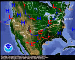
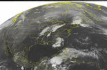
Current Radar and Satellite


UV Index
Value: None
Cold Index
Value: Low
Flu Index
Value: None
Latest Weather News from New Orleans

Sleet possible Wednesday night in Baton Rouge, St. Tammany Parish

By
January 02, 2013, 6:07PM
An unusual layer of below freezing air 10,000 to 15,000 feet above the ground could freeze rain droplets over some parts of the Florida Parishes in Louisiana, allowing some to reach the surface as sleet overnight Wednesday in Baton Rouge and St. Tammany Parish, according to the Slidell office of the National Weather Service. New Orleans and other locations south... Full story »
Rainfall to provide New Year's greeting in Baton Rouge, New Orleans today

By
January 01, 2013, 12:06PM
Rainfall accompanying a cold front is moving more slowly than expected into southeastern Louisiana on New Year's Day, with scattered showers now moving into Baton Rouge and expected to reach New Orleans by the afternoon. Forecasters with the Slidell office of the National Weather Service are predicting between 1 and 2 inches of rain to fall over the area during... Full story »
Wet weather to arrive in Baton Rouge, New Orleans early New Year's Day
By
December 31, 2012, 3:48PM
A strong cold front that was dropping snow across the Midwest this weekend will trigger a three-day spate of chilly rainfall in Baton Rouge and New Orleans beginning early New Year's Day. Between 1 and 2 inches of rain could accumulate through Thursday, according to a forecaster with the Slidell office of the National Weather Service. The rain is... Full story »
Advertisement:
Chance of rain for Southeast Louisiana through Thursday

By
December 31, 2012, 2:20AM
A slight chance of rain during the day in Southeast Louisiana on Monday increases to about a 40 percent chance of showers New Year's Eve, with significant rainfall possibly holding off until after midnight, according to forecasters with the Slidell office of the National Weather Service. New Year's Day will see showers mixed with isolated thunderstorms, resulting in a... Full story »
Hard freeze and freeze warnings for much of New Orleans area Saturday night and early Sunday

By
December 29, 2012, 6:48PM
Icebox-like air moving into southeastern Louisiana in the aftermath of a cold front has prompted the Slidell office of the National Weather Service to issue freeze warnings for much of the New Orleans are for Saturday night and early Sunday. A hard freeze warning is in effect from midnight Saturday until 9 a.m. Sunday for areas north and west of... Full story »
Pearl River flooding likely after Friday storm, Weather Service says
By
December 28, 2012, 5:02PM
The Pearl River could see minor flooding in the next few days, and is expected to rise above flood stage by Tuesday following today's storms. Full story »
Inappropriate post? Alert us.
Heavy rains moving into New Orleans area Friday afternoon

By
December 28, 2012, 2:29PM
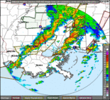
A line of thunderstorms producing very heavy rain and wind gusts of 25 to 30 mph is expected to move across the New Orleans area over the next few hours. These thunderstorms could produce rainfall at a rate of up to an inch per hour, according to a hazardous weather outlook issued by the Slidell office of the National Weather... Full story »
A wet end to a busy Louisiana weather year

By
December 27, 2012, 5:04PM
The end of a busy weather year promises two more chances of rainfall, including on New Year's Eve. It will mark a wet end to 2012, which began with near-drought conditions in New Orleans. Forecasters with the Slidell office of the National Weather Service are expecting another cold front to usher in showers and thunderstorms to the area Friday... Full story »
Powerful storm kills 6, snarls holiday travel

By
December 27, 2012, 7:19AM
CONCORD, N.H. -- A powerful winter storm was expected to drop 1 to 2 feet of snow on parts of the Northeast just a day after it swept through the nation's middle, dumping a record snowfall in Arkansas and ruining holiday travel plans for thousands. The storm, which was blamed for six deaths, pushed through the Upper Ohio Valley... Full story »
Storm system moving northeast after spawning tornadoes in the South

By
December 26, 2012, 7:04AM
MOBILE, Ala. -- An enormous storm system that dumped snow and sleet on the nation's midsection and unleashed damaging tornadoes around the Deep South began punching its way toward the Northeast on Wednesday, slowing holiday travel. Post-Christmas travelers braced for flight delays and a raft of weather warnings for drivers, a day after rare winter twisters damaged buildings in... Full story »
Entergy expects to restore New Orleans power by 8 p.m., statewide by 3 a.m.
By
December 25, 2012, 5:42PM
Entergy expects to restore power in the New Orleans metropolitan area by 8 p.m. and throughout the state by 3 a.m., said Molly Jahncke, communications manager for Louisiana. "Some outages are not as terrible as we thought they might be," she said. "It seems like the weather system is moving through relatively quickly." The number of homes without power... Full story »
Inappropriate post? Alert us.
Severe thunderstorm warning for St. John the Baptist, Lafourche, Assumption, Terrebonne parishes

By
December 25, 2012, 5:10PM
The National Weather Service has issued a severe thunderstorm warning for extreme southwestern St. John the Baptist Parish, southern Assumption, central Lafourche and Terrebonne parishes until 6:15 p.m. This includes the cities of Thibodaux and Houma. At 5:06 p.m, meteorologists detected a severe thunderstorm capable of producing quarter size hail and damaging winds in excess of 60 mph, located 44... Full story »
Severe thunderstorm warning for St. John the Baptist, St. Tammany, Tangipahoa, Washington parishes
By
December 25, 2012, 4:40PM
The National Weather Service has issued a severe thunderstorm warning for extreme northeastern St. John the Baptist, St. Tammany, southeastern Tangipahoa, and Washington parishes until 5:45 p.m., including Slidell, Mandeville Eden Isle, Covington, Franklinton and Bogalusa. At 4:41 p.m., meteorologists detected a line of severe thunderstorms capable of producing quarter size hail and destructive winds in excess of 70 mph... Full story »
Tornado touches down in Zachary
By
December 25, 2012, 3:54PM
A tornado made landfall in Zachary earlier this afternoon, according to a representative from the Zachary Police Department. Although the exact location of the twister is unknown, it is believed to have touched down around 3 pm today. The Zachary Police Department has not received any other reports of tornados making landfall, although there have been reports of downed trees... Full story »
Inappropriate post? Alert us.
- METRO NEW ORLEANS WEATHER NEWS
- WEATHER RESOURCES
-
• 5-day Forecast

- YOUR WEATHER PHOTOS
-
- Find & Share Photos
- Tag your photos 'weather' to appear on this page.
- RELATED NEW ORLEANS WEATHER LINKS