Map
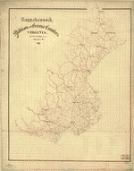
[Map of Madison County, Va.].

| Format |
Map |
|---|---|
| Location |
Madison County United States Virginia |
| Language |
English |
| Subjects |
Landowners Madison County Madison County (Va.) United States Virginia |
- Title
- [Map of Madison County, Va.].
- Description
-
LC Land ownership maps, 1297
-
Relief shown by form lines.
-
Show names of some residents.
-
Date, title, and scale from Stephenson's Civil War maps, 1989.
-
LC Civil War maps (2nd ed.), H46
-
Available also through the Library of Congress web site as raster image.
-
1 map : col. ms. ; 28 x 22 cm.
- Created Published
-
[186-]
- Subject Headings
-
-
Madison County (Va.)
-
-
Landowners--Virginia--Madison County
-
-
United States--Virginia--Madison County.
- Notes
-
-
LC Land ownership maps, 1297
-
-
Relief shown by form lines.
-
-
Show names of some residents.
-
-
Date, title, and scale from Stephenson's Civil War maps, 1989.
-
-
LC Civil War maps (2nd ed.), H46
-
-
Available also through the Library of Congress web site as raster image.
- Medium
-
1 map : col. ms. ; 28 x 22 cm.
- Call Number
-
G3883.M2 186- .M2
- Repository
-
Library of Congress Geography and Map Division Washington, D.C. 20540-4650 dcu
- Digital Id
-
g3883m cwh00046 http://hdl.loc.gov/loc.gmd/g3883m.cwh00046
- Library of Congress Catalog Number
- 2002627454
Rights & Access
The maps in the Map Collections materials were either published prior to 1922, produced by the United States government, or both (see catalogue records that accompany each map for information regarding date of publication and source). The Library of Congress is providing access to these materials for educational and research purposes and is not aware of any U.S. copyright protection (see Title 17 of the United States Code) or any other restrictions in the Map Collection materials.
Note that the written permission of the copyright owners and/or other rights holders (such as publicity and/or privacy rights) is required for distribution, reproduction, or other use of protected items beyond that allowed by fair use or other statutory exemptions. Responsibility for making an independent legal assessment of an item and securing any necessary permissions ultimately rests with persons desiring to use the item.
More about Copyright and other Restrictions
For guidance about compiling full citations consult Citing Primary Sources.
Part of...
-
Hotchkiss Map Collection
[345]
-
Cultural Landscapes
[1623]
-
Civil War Maps
[2281]
-
Military Battles And Campaigns Cartographic Items
[3867]
-
Geography And Maps Division
[60803]
-
American Memory
[1121009]
More maps like this
-
 [Sketches of portions of Madison County, Va.].
Site:
American Memory-cultural, Main Catalog
Original Format:
Map
View catalog record
[Sketches of portions of Madison County, Va.].
Site:
American Memory-cultural, Main Catalog
Original Format:
Map
View catalog record
-
 Survey of Culpeper and a part of Madison counties, Virginia /
Contributor:
Dwight, C. S.
Site:
American Memory-cultural, Main Catalog
Original Format:
Map
Date:
1863
View catalog record
Survey of Culpeper and a part of Madison counties, Virginia /
Contributor:
Dwight, C. S.
Site:
American Memory-cultural, Main Catalog
Original Format:
Map
Date:
1863
View catalog record
-
 [Sketch of the road from Madison northward to Dulaney's in Madison County, Va.].
Site:
American Memory-cultural, Main Catalog
Original Format:
Map
View catalog record
[Sketch of the road from Madison northward to Dulaney's in Madison County, Va.].
Site:
American Memory-cultural, Main Catalog
Original Format:
Map
View catalog record
-
 [Culpeper County with parts of Madison, Rappahannock, and Fauquier counties, Virginia].
Contributor:
United States. Army. Corps of Topographical Engineers
Site:
American Memory-cultural, Main Catalog
Original Format:
Map
Date:
1863
View catalog record
[Culpeper County with parts of Madison, Rappahannock, and Fauquier counties, Virginia].
Contributor:
United States. Army. Corps of Topographical Engineers
Site:
American Memory-cultural, Main Catalog
Original Format:
Map
Date:
1863
View catalog record
-
 [Map of Culpeper County with parts of Madison, Rappahannock, and Fauquier counties, Virginia] /
Contributor:
United States. Army. Corps of Topographical Engineers
Site:
American Memory-cultural, Main Catalog
Original Format:
Map
Date:
1863
View catalog record
[Map of Culpeper County with parts of Madison, Rappahannock, and Fauquier counties, Virginia] /
Contributor:
United States. Army. Corps of Topographical Engineers
Site:
American Memory-cultural, Main Catalog
Original Format:
Map
Date:
1863
View catalog record
-
 Rappahannock, Madison, and Greene counties, Virginia /
Contributor:
Hotchkiss, Jedediah
Site:
American Memory-cultural, Main Catalog
Original Format:
Map
Date:
1867
View catalog record
Rappahannock, Madison, and Greene counties, Virginia /
Contributor:
Hotchkiss, Jedediah
Site:
American Memory-cultural, Main Catalog
Original Format:
Map
Date:
1867
View catalog record
-
 [Map of the counties of Greene, Madison, Page, and Rockingham, and parts of the counties of Albemarle, Augusta, Culpeper, Louisa, Orange, and Rappahannock, Va.]
Site:
American Memory-cultural
Original Format:
Map
Date:
1864
[Map of the counties of Greene, Madison, Page, and Rockingham, and parts of the counties of Albemarle, Augusta, Culpeper, Louisa, Orange, and Rappahannock, Va.]
Site:
American Memory-cultural
Original Format:
Map
Date:
1864
-
 Map of Culpeper, Madison and Rappahannock /
Contributor:
Dwight, C. S.
Site:
American Memory-cultural
Original Format:
Map
Date:
1864
Map of Culpeper, Madison and Rappahannock /
Contributor:
Dwight, C. S.
Site:
American Memory-cultural
Original Format:
Map
Date:
1864
-
 Map of Madison county, Alabama /
Contributor:
Mayhew, James H.
Site:
American Memory-cultural, Main Catalog
Original Format:
Map
Date:
1875
View catalog record
Map of Madison county, Alabama /
Contributor:
Mayhew, James H.
Site:
American Memory-cultural, Main Catalog
Original Format:
Map
Date:
1875
View catalog record
-
 Atlas of Madison County, Iowa /
Contributor:
Midland Map Company (Knoxville, Iowa)
Site:
American Memory-cultural, Main Catalog
Original Format:
Map
Date:
1912
View catalog record
Atlas of Madison County, Iowa /
Contributor:
Midland Map Company (Knoxville, Iowa)
Site:
American Memory-cultural, Main Catalog
Original Format:
Map
Date:
1912
View catalog record
-
 Caldwell's atlas of Madison Co., Ohio /
Contributor:
Cring, Henry
Site:
American Memory-cultural, Main Catalog
Original Format:
Map
Date:
1875
View catalog record
Caldwell's atlas of Madison Co., Ohio /
Contributor:
Cring, Henry
Site:
American Memory-cultural, Main Catalog
Original Format:
Map
Date:
1875
View catalog record
-
 Map of Madison County, Texas.
Contributor:
Texas. General Land Office
Site:
American Memory-cultural, Main Catalog
Original Format:
Map
Date:
1879
View catalog record
Map of Madison County, Texas.
Contributor:
Texas. General Land Office
Site:
American Memory-cultural, Main Catalog
Original Format:
Map
Date:
1879
View catalog record
-
 Standard atlas of Madison County, Illinois : including a plat book of the villages, cities and townships of the county, map of the state, United ...
Contributor:
Geo. A. Ogle & Co
Site:
American Memory-cultural, Main Catalog
Original Format:
Map
Date:
1906
View catalog record
Standard atlas of Madison County, Illinois : including a plat book of the villages, cities and townships of the county, map of the state, United ...
Contributor:
Geo. A. Ogle & Co
Site:
American Memory-cultural, Main Catalog
Original Format:
Map
Date:
1906
View catalog record
-
 Map of Hamilton, Madison County, New York /
Contributor:
Clark, Benjamin A.
Site:
American Memory-cultural
Original Format:
Map
Date:
1858
Map of Hamilton, Madison County, New York /
Contributor:
Clark, Benjamin A.
Site:
American Memory-cultural
Original Format:
Map
Date:
1858
-
 Map of a portion of eastern Virginia, from a map in progress /
Contributor:
Patton, J. Houston
Site:
American Memory-cultural, Main Catalog
Original Format:
Map
Date:
1864
View catalog record
Map of a portion of eastern Virginia, from a map in progress /
Contributor:
Patton, J. Houston
Site:
American Memory-cultural, Main Catalog
Original Format:
Map
Date:
1864
View catalog record
-
 [Preliminary map of northeastern Virginia, south of the Rappahannock, east of the Blue Ridge, and north of 38p0s N. Lat.].
Site:
American Memory-cultural, Main Catalog
Original Format:
Map
Date:
1864
View catalog record
[Preliminary map of northeastern Virginia, south of the Rappahannock, east of the Blue Ridge, and north of 38p0s N. Lat.].
Site:
American Memory-cultural, Main Catalog
Original Format:
Map
Date:
1864
View catalog record
You might also like
-
 Hebron Church, Craigersville vic., Madison County, Virginia
Contributor:
Johnston, Frances Benjamin
Site:
Prints & Photographs
Original Format:
Photo, Print, Drawing
Date:
1930
Hebron Church, Craigersville vic., Madison County, Virginia
Contributor:
Johnston, Frances Benjamin
Site:
Prints & Photographs
Original Format:
Photo, Print, Drawing
Date:
1930
-
 Madison County Courthouse, U.S. Route 29, Madison, Madison County, VA
Contributor:
Historic American Buildings Survey
Site:
Prints & Photographs
Original Format:
Photo, Print, Drawing
Madison County Courthouse, U.S. Route 29, Madison, Madison County, VA
Contributor:
Historic American Buildings Survey
Site:
Prints & Photographs
Original Format:
Photo, Print, Drawing
-
 Hebron Lutheran Church, State Routes 638 & 653, Madison, Madison County, VA
Contributor:
Historic American Buildings Survey
Site:
Prints & Photographs
Original Format:
Photo, Print, Drawing
Hebron Lutheran Church, State Routes 638 & 653, Madison, Madison County, VA
Contributor:
Historic American Buildings Survey
Site:
Prints & Photographs
Original Format:
Photo, Print, Drawing