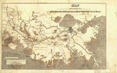
Map
Sketch showing the route of the New Orleans, Opelousas & Great Western Rail Road, J. G. Gibbes, Chief Engr., lithographie [sic] agent D. Theuret, Exange Alley, Nr. 130.

| Format |
Map |
|---|---|
| Contributors |
Okelomski, F. A. |
| Dates |
1853 |
| Location |
Southwestern States United States |
| Language |
English |
| Subjects |
New Orleans, Opelousas, And Great Western Railroad Company Railroads Southwestern States United States |
- Title
- Sketch showing the route of the New Orleans, Opelousas & Great Western Rail Road, J. G. Gibbes, Chief Engr., lithographie [sic] agent D. Theuret, Exange Alley, Nr. 130.
- Description
-
Scale 1:3,041,280.
-
Relief shown by hachures.
-
Across top of map: "Distance from New Orleans to the Pacific 1600 miles ".
-
LC Railroad maps, 478
-
Description derived from published bibliography.
-
Rough outline map of the southwestern United States showing major rivers and few important cities.
-
Available also through the Library of Congress Web site as a raster image.
-
map 45 x 75 cm.
- Creator
- Okelomski, F. A.
- Created Published
-
[New Orleans], 1853.
- Subject Headings
-
-
New Orleans, Opelousas, and Great Western Railroad Company
-
-
Railroads--Southwestern States
-
-
United States--Southwestern States.
- Notes
-
-
Scale 1:3,041,280.
-
-
Relief shown by hachures.
-
-
Across top of map: "Distance from New Orleans to the Pacific 1600 miles ".
-
-
LC Railroad maps, 478
-
-
Description derived from published bibliography.
-
-
Rough outline map of the southwestern United States showing major rivers and few important cities.
-
-
Available also through the Library of Congress Web site as a raster image.
- Medium
-
map 45 x 75 cm.
- Call Number
-
G4296.P3 1853 .O39
- Repository
-
Library of Congress Geography and Map Division Washington, D.C. 20540-4650 USA dcu
- Digital Id
-
g4296p rr004780 http://hdl.loc.gov/loc.gmd/g4296p.rr004780
- Library of Congress Catalog Number
- 98688728
Rights & Access
The maps in the Map Collections materials were either published prior to 1922, produced by the United States government, or both (see catalogue records that accompany each map for information regarding date of publication and source). The Library of Congress is providing access to these materials for educational and research purposes and is not aware of any U.S. copyright protection (see Title 17 of the United States Code) or any other restrictions in the Map Collection materials.
Note that the written permission of the copyright owners and/or other rights holders (such as publicity and/or privacy rights) is required for distribution, reproduction, or other use of protected items beyond that allowed by fair use or other statutory exemptions. Responsibility for making an independent legal assessment of an item and securing any necessary permissions ultimately rests with persons desiring to use the item.
More about Copyright and other Restrictions
For guidance about compiling full citations consult Citing Primary Sources.
Part of...
-
Railroad Maps, 1828 1900
[617]
-
Transportation And Communication Cartographic Items
[761]
-
Geography And Maps Division
[60803]
-
American Memory
[1121009]
More maps like this
-
 Map exhibiting the fixed location of the main trunk of the New-Orleans, Opelousas & Great Western Railroad of Louisiana, together with its proposed branches, connections ...
Contributor:
Bayley, G. W. R.
Site:
American Memory-cultural, Main Catalog
Original Format:
Map
Date:
1859
View catalog record
Map exhibiting the fixed location of the main trunk of the New-Orleans, Opelousas & Great Western Railroad of Louisiana, together with its proposed branches, connections ...
Contributor:
Bayley, G. W. R.
Site:
American Memory-cultural, Main Catalog
Original Format:
Map
Date:
1859
View catalog record
-
 Map of a part of the State of Louisiana exhibiting the route of the New-Orleans, Opelousas & Great Western Rail Road.
Contributor:
Bayley, G. W. R.
Site:
American Memory-cultural, Main Catalog
Original Format:
Map
Date:
1853
View catalog record
Map of a part of the State of Louisiana exhibiting the route of the New-Orleans, Opelousas & Great Western Rail Road.
Contributor:
Bayley, G. W. R.
Site:
American Memory-cultural, Main Catalog
Original Format:
Map
Date:
1853
View catalog record
-
 From Fort Smith to the Rio Grande : from explorations and surveys /
Contributor:
Hoffman, J. D.
Site:
American Memory-cultural, Main Catalog
Original Format:
Map
Date:
1859
View catalog record
From Fort Smith to the Rio Grande : from explorations and surveys /
Contributor:
Hoffman, J. D.
Site:
American Memory-cultural, Main Catalog
Original Format:
Map
Date:
1859
View catalog record
-
 A map of the Internal Provinces of New Spain.
Contributor:
Pike, Zebulon Montgomery
Site:
American Memory-cultural, Main Catalog
Original Format:
Map
Date:
1807
View catalog record
A map of the Internal Provinces of New Spain.
Contributor:
Pike, Zebulon Montgomery
Site:
American Memory-cultural, Main Catalog
Original Format:
Map
Date:
1807
View catalog record
-
 The American Union railroad map of the United States, British possessions, West Indies, Mexico and Central America.
Contributor:
Haasis & Lubrecht
Site:
American Memory-cultural, Main Catalog
Original Format:
Map
Date:
1872
View catalog record
The American Union railroad map of the United States, British possessions, West Indies, Mexico and Central America.
Contributor:
Haasis & Lubrecht
Site:
American Memory-cultural, Main Catalog
Original Format:
Map
Date:
1872
View catalog record
-
 Carte des États-unis d'Amérique.
Contributor:
Bouffard, L.
Site:
American Memory-cultural, Main Catalog
Original Format:
Map
Date:
1836
View catalog record
Carte des États-unis d'Amérique.
Contributor:
Bouffard, L.
Site:
American Memory-cultural, Main Catalog
Original Format:
Map
Date:
1836
View catalog record
-
 Map of the railroads in the United States in operation and progress
Contributor:
Andrews, Israel De Wolf
Site:
American Memory-cultural, Main Catalog
Original Format:
Map
Date:
1852
View catalog record
Map of the railroads in the United States in operation and progress
Contributor:
Andrews, Israel De Wolf
Site:
American Memory-cultural, Main Catalog
Original Format:
Map
Date:
1852
View catalog record
-
 Map of routes for a Pacific railroad, compiled to accompany a report of the Hon. Jefferson Davis, sec. of war.
Contributor:
Warren, G. K.
Site:
American Memory-cultural, Main Catalog
Original Format:
Map
Date:
1857
View catalog record
Map of routes for a Pacific railroad, compiled to accompany a report of the Hon. Jefferson Davis, sec. of war.
Contributor:
Warren, G. K.
Site:
American Memory-cultural, Main Catalog
Original Format:
Map
Date:
1857
View catalog record
-
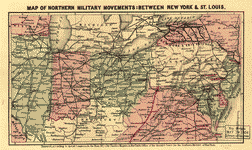 Map of northern military movements: between New York & St. Louis
Contributor:
Magnus, Charles
Site:
American Memory-cultural, Main Catalog
Original Format:
Map
Date:
1861
View catalog record
Map of northern military movements: between New York & St. Louis
Contributor:
Magnus, Charles
Site:
American Memory-cultural, Main Catalog
Original Format:
Map
Date:
1861
View catalog record
-
 Lloyd's American railroad map, showing the whole seat of the war.
Contributor:
Lloyd, James T.
Site:
American Memory-cultural, Main Catalog
Original Format:
Map
Date:
1861
View catalog record
Lloyd's American railroad map, showing the whole seat of the war.
Contributor:
Lloyd, James T.
Site:
American Memory-cultural, Main Catalog
Original Format:
Map
Date:
1861
View catalog record
-
 A new and complete rail road map of the United States compiled from reliable sources by William Perris, C.E. & Surveyor, New York; presented by ...
Contributor:
Perris, William
Site:
American Memory-cultural, Main Catalog
Original Format:
Map
Date:
1858
View catalog record
A new and complete rail road map of the United States compiled from reliable sources by William Perris, C.E. & Surveyor, New York; presented by ...
Contributor:
Perris, William
Site:
American Memory-cultural, Main Catalog
Original Format:
Map
Date:
1858
View catalog record
-
 [Outline map of the United States showing proposed railroad routes to the Pacific].
Contributor:
McAlpine, William J.
Site:
American Memory-cultural, Main Catalog
Original Format:
Map
Date:
1853
View catalog record
[Outline map of the United States showing proposed railroad routes to the Pacific].
Contributor:
McAlpine, William J.
Site:
American Memory-cultural, Main Catalog
Original Format:
Map
Date:
1853
View catalog record
-
 Lloyd's American railroad map.
Contributor:
Lloyd, James T.
Site:
American Memory-cultural, Main Catalog
Original Format:
Map
Date:
1861
View catalog record
Lloyd's American railroad map.
Contributor:
Lloyd, James T.
Site:
American Memory-cultural, Main Catalog
Original Format:
Map
Date:
1861
View catalog record
-
 J. Sage & Son's new & reliable rail road map comprising all the railroads of the United States and Canadas with their stations and distances,
Contributor:
Stammann, Hugo
Site:
American Memory-cultural, Main Catalog
Original Format:
Map
Date:
1858
View catalog record
J. Sage & Son's new & reliable rail road map comprising all the railroads of the United States and Canadas with their stations and distances,
Contributor:
Stammann, Hugo
Site:
American Memory-cultural, Main Catalog
Original Format:
Map
Date:
1858
View catalog record
-
 Map of all the railroads in the United States in operation and progress; drawn and engraved under direction of the editor of the American railroad ...
Site:
American Memory-cultural, Main Catalog
Original Format:
Map
Date:
1854
View catalog record
Map of all the railroads in the United States in operation and progress; drawn and engraved under direction of the editor of the American railroad ...
Site:
American Memory-cultural, Main Catalog
Original Format:
Map
Date:
1854
View catalog record
-
 Dinsmore's complete map of the railroads & canals in the United States & Canada carefully compiled from authentic sources by Richard S. Fisher, editor of ...
Contributor:
Fisher, Richard Swainson
Site:
American Memory-cultural, Main Catalog
Original Format:
Map
Date:
1856
View catalog record
Dinsmore's complete map of the railroads & canals in the United States & Canada carefully compiled from authentic sources by Richard S. Fisher, editor of ...
Contributor:
Fisher, Richard Swainson
Site:
American Memory-cultural, Main Catalog
Original Format:
Map
Date:
1856
View catalog record
You might also like
-
 Conductor working on his records in the caboose enroute to Canadian, Texas
Contributor:
Delano, Jack
Site:
Prints & Photographs
Original Format:
Photo, Print, Drawing
Date:
1943
Conductor working on his records in the caboose enroute to Canadian, Texas
Contributor:
Delano, Jack
Site:
Prints & Photographs
Original Format:
Photo, Print, Drawing
Date:
1943
-
 General view of part of an Atchison, Topeka and Santa Fe Railroad yard
Contributor:
Delano, Jack
Site:
Prints & Photographs
Original Format:
Photo, Print, Drawing
Date:
1943
General view of part of an Atchison, Topeka and Santa Fe Railroad yard
Contributor:
Delano, Jack
Site:
Prints & Photographs
Original Format:
Photo, Print, Drawing
Date:
1943
-
 Making up trains in an Atchison, Topeka and Santa Fe Railroad yard
Contributor:
Delano, Jack
Site:
Prints & Photographs
Original Format:
Photo, Print, Drawing
Date:
1943
Making up trains in an Atchison, Topeka and Santa Fe Railroad yard
Contributor:
Delano, Jack
Site:
Prints & Photographs
Original Format:
Photo, Print, Drawing
Date:
1943
-
 General view of a Atchison, Topeka and Santa Fe Railroad yard
Contributor:
Delano, Jack
Site:
Prints & Photographs
Original Format:
Photo, Print, Drawing
Date:
1943
General view of a Atchison, Topeka and Santa Fe Railroad yard
Contributor:
Delano, Jack
Site:
Prints & Photographs
Original Format:
Photo, Print, Drawing
Date:
1943
-
 Sandstorm over a Atchison, Topeka and Santa Fe Railroad yard
Contributor:
Delano, Jack
Site:
Prints & Photographs
Original Format:
Photo, Print, Drawing
Date:
1943
Sandstorm over a Atchison, Topeka and Santa Fe Railroad yard
Contributor:
Delano, Jack
Site:
Prints & Photographs
Original Format:
Photo, Print, Drawing
Date:
1943