Map
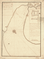
Baye de Matance dans l'isle de Cube.

| Format |
Map |
|---|---|
| Contributors |
Bellin, Jacques Nicolas |
| Dates |
1764 |
| Location |
Cuba Matanzas Bay |
| Language |
French |
| Subjects |
Cuba Matanzas Bay Matanzas Bay (Cuba) Nautical Charts |
- Title
- Baye de Matance dans l'isle de Cube.
- Description
-
Scale ca. 1:70,000.
-
Relief shown pictorially. Soundings shown in fathoms.
-
LC Maps of North America, 1750-1789, 1828
-
Available also through the Library of Congress Web site as a raster image.
-
"Tome I, no. 52."
-
From the author's Le petit atlas maritime. 1764.
-
map, 21 x 16 cm.
- Creator
- Bellin, Jacques Nicolas,
- Created Published
-
[Paris, 1764]
- Subject Headings
-
-
Matanzas Bay (Cuba)
-
-
Nautical charts--Cuba--Matanzas Bay
-
-
Cuba--Matanzas Bay.
- Notes
-
-
Scale ca. 1:70,000.
-
-
Relief shown pictorially. Soundings shown in fathoms.
-
-
LC Maps of North America, 1750-1789, 1828
-
-
Available also through the Library of Congress Web site as a raster image.
-
-
"Tome I, no. 52."
-
-
From the author's Le petit atlas maritime. 1764.
- Medium
-
map, 21 x 16 cm.
- Call Number
-
G4922.M3 1764 .B4
- Repository
-
Library of Congress Geography and Map Division Washington, D.C. 20540-4650 USA dcuie
- Digital Id
-
g4922m ar182800 http://hdl.loc.gov/loc.gmd/g4922m.ar182800
- Library of Congress Catalog Number
- 73697700
Rights & Access
The maps in the Map Collections materials were either published prior to 1922, produced by the United States government, or both (see catalogue records that accompany each map for information regarding date of publication and source). The Library of Congress is providing access to these materials for educational and research purposes and is not aware of any U.S. copyright protection (see Title 17 of the United States Code) or any other restrictions in the Map Collection materials.
Note that the written permission of the copyright owners and/or other rights holders (such as publicity and/or privacy rights) is required for distribution, reproduction, or other use of protected items beyond that allowed by fair use or other statutory exemptions. Responsibility for making an independent legal assessment of an item and securing any necessary permissions ultimately rests with persons desiring to use the item.
More about Copyright and other Restrictions
For guidance about compiling full citations consult Citing Primary Sources.
Part of...
More maps like this
-
 Plan of the city and harbour of the Havana. Plan of Bahía de Matanzas.
Contributor:
Jefferys, Thomas
Site:
American Memory-cultural, Main Catalog
Original Format:
Map
Date:
1768
View catalog record
Plan of the city and harbour of the Havana. Plan of Bahía de Matanzas.
Contributor:
Jefferys, Thomas
Site:
American Memory-cultural, Main Catalog
Original Format:
Map
Date:
1768
View catalog record
-
 Plano del Puerto de Matanzas situado en la costa del norte de la ysla de Cuba en 23p0s 10 ms. de latd. N. y en ...
Site:
American Memory-cultural, Main Catalog
Original Format:
Map
Date:
1700
View catalog record
Plano del Puerto de Matanzas situado en la costa del norte de la ysla de Cuba en 23p0s 10 ms. de latd. N. y en ...
Site:
American Memory-cultural, Main Catalog
Original Format:
Map
Date:
1700
View catalog record
-
 Plano del Puerto de Matanzas situado en la costa del norte de la ysla de Cuba en 23 gs. 10 ms. de latd. norte y ...
Site:
American Memory-cultural, Main Catalog
Original Format:
Map
Date:
1700
View catalog record
Plano del Puerto de Matanzas situado en la costa del norte de la ysla de Cuba en 23 gs. 10 ms. de latd. norte y ...
Site:
American Memory-cultural, Main Catalog
Original Format:
Map
Date:
1700
View catalog record
-
 Plano del Puerto de Matanzas situado en la costa del norte de la ysla de Cuba en 23p0s10ʹ de latid. norte y en la 293p0s40ʹ ...
Site:
American Memory-cultural, Main Catalog
Original Format:
Map
Date:
1725
View catalog record
Plano del Puerto de Matanzas situado en la costa del norte de la ysla de Cuba en 23p0s10ʹ de latid. norte y en la 293p0s40ʹ ...
Site:
American Memory-cultural, Main Catalog
Original Format:
Map
Date:
1725
View catalog record
-
 Matanzas ... puerto situado en la vanda del nortte de la Isla de Cuba en 23 grados y 10 minutos de latittd. d. nortte y ...
Contributor:
Cumplido, Francisco
Site:
American Memory-cultural, Main Catalog
Original Format:
Map
Date:
1700
View catalog record
Matanzas ... puerto situado en la vanda del nortte de la Isla de Cuba en 23 grados y 10 minutos de latittd. d. nortte y ...
Contributor:
Cumplido, Francisco
Site:
American Memory-cultural, Main Catalog
Original Format:
Map
Date:
1700
View catalog record
-
 Plano del puerto y ciudad de Matanzas situada en la costa septentrional de la ysla de Cuba en la latitud de 23p0s12ʹ y en la ...
Contributor:
Torres, Manuel Guirez de
Site:
American Memory-cultural, Main Catalog
Original Format:
Map
Date:
1815
View catalog record
Plano del puerto y ciudad de Matanzas situada en la costa septentrional de la ysla de Cuba en la latitud de 23p0s12ʹ y en la ...
Contributor:
Torres, Manuel Guirez de
Site:
American Memory-cultural, Main Catalog
Original Format:
Map
Date:
1815
View catalog record
-
 Plan de la baye de St. Yago dans l'isle de Cube.
Contributor:
Bellin, Jacques Nicolas
Site:
American Memory-cultural, Main Catalog
Original Format:
Map
Date:
1764
View catalog record
Plan de la baye de St. Yago dans l'isle de Cube.
Contributor:
Bellin, Jacques Nicolas
Site:
American Memory-cultural, Main Catalog
Original Format:
Map
Date:
1764
View catalog record
-
 Entrée de la baye de St. Yago dans l'isle de Cube.
Contributor:
Bellin, Jacques Nicolas
Site:
American Memory-cultural, Main Catalog
Original Format:
Map
Date:
1764
View catalog record
Entrée de la baye de St. Yago dans l'isle de Cube.
Contributor:
Bellin, Jacques Nicolas
Site:
American Memory-cultural, Main Catalog
Original Format:
Map
Date:
1764
View catalog record
-
 Carte hydrographique de la baye de la Havana. Avec le Plan de la ville et de ses forts pour joindre a la Carte de l'isle ...
Contributor:
Bellin, Jacques Nicolas
Site:
American Memory-cultural, Main Catalog
Original Format:
Map
Date:
1791
View catalog record
Carte hydrographique de la baye de la Havana. Avec le Plan de la ville et de ses forts pour joindre a la Carte de l'isle ...
Contributor:
Bellin, Jacques Nicolas
Site:
American Memory-cultural, Main Catalog
Original Format:
Map
Date:
1791
View catalog record
-
 Carte réduite de l'isle de Cube.
Contributor:
Bellin, Jacques Nicolas
Site:
American Memory-cultural, Main Catalog
Original Format:
Map
Date:
1807
View catalog record
Carte réduite de l'isle de Cube.
Contributor:
Bellin, Jacques Nicolas
Site:
American Memory-cultural, Main Catalog
Original Format:
Map
Date:
1807
View catalog record
-
 Isle de Cube.
Contributor:
Bellin, Jacques Nicolas
Site:
American Memory-cultural, Main Catalog
Original Format:
Map
Date:
1764
View catalog record
Isle de Cube.
Contributor:
Bellin, Jacques Nicolas
Site:
American Memory-cultural, Main Catalog
Original Format:
Map
Date:
1764
View catalog record
-
 Carte réduite de l'isle de Saint Domingue et de ses débouquements pour servir aux vaisseaux du roy. Dréssée au Dépost des cartes plans et journaux ...
Contributor:
Bellin, Jacques Nicolas
Site:
American Memory-cultural, Main Catalog
Original Format:
Map
Date:
1750
View catalog record
Carte réduite de l'isle de Saint Domingue et de ses débouquements pour servir aux vaisseaux du roy. Dréssée au Dépost des cartes plans et journaux ...
Contributor:
Bellin, Jacques Nicolas
Site:
American Memory-cultural, Main Catalog
Original Format:
Map
Date:
1750
View catalog record
-
 L'hydrographie françoise : recueil des cartes générales et particulières qui ont éte faites pour le service des vaisseaux du roy, par ordre des Ministres de ...
Contributor:
Bellin, Jacques Nicolas
Site:
American Memory-cultural, Main Catalog
Original Format:
Map
Date:
1737
View catalog record
L'hydrographie françoise : recueil des cartes générales et particulières qui ont éte faites pour le service des vaisseaux du roy, par ordre des Ministres de ...
Contributor:
Bellin, Jacques Nicolas
Site:
American Memory-cultural, Main Catalog
Original Format:
Map
Date:
1737
View catalog record
-
 Plan de puerto de Mariel
Contributor:
Jefferys, Thomas
Site:
American Memory-cultural, Main Catalog
Original Format:
Map
Date:
1768
View catalog record
Plan de puerto de Mariel
Contributor:
Jefferys, Thomas
Site:
American Memory-cultural, Main Catalog
Original Format:
Map
Date:
1768
View catalog record
-
 [Cape Corientes, 175-?]
Site:
American Memory-cultural, Main Catalog
Original Format:
Map
Date:
1750
View catalog record
[Cape Corientes, 175-?]
Site:
American Memory-cultural, Main Catalog
Original Format:
Map
Date:
1750
View catalog record
You might also like
-
-

 Under three flags in Cuba; a personal account of the Cuban insurrection and Spanish-American war,
Contributor:
Musgrave, George Clarke
Site:
Main Catalog
Original Format:
Book
Date:
1899
Under three flags in Cuba; a personal account of the Cuban insurrection and Spanish-American war,
Contributor:
Musgrave, George Clarke
Site:
Main Catalog
Original Format:
Book
Date:
1899
-
-
To Cuba and back in twenty-two days.
Contributor:
Cattell, Alexander Gilmore
Site:
Main Catalog
Original Format:
Book
Date:
1874
-
-
Juicio de residencia del escelentisimo señoe Don Miguel Tacón, vizconde del Bayamo, marqués de la Union de Cuba ...
Contributor:
Olañeta, José Antonio de
Site:
Main Catalog
Original Format:
Book
Date:
1839