


 View full size
A project involving a number of local and state agencies and the private North Coast Land Conservancy will reduce flooding along U.S. Highway 101 near Seaside.
View full size
A project involving a number of local and state agencies and the private North Coast Land Conservancy will reduce flooding along U.S. Highway 101 near Seaside.
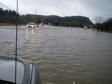
The result, anything but subtle, was as predictable as rain: blocked passage for vacationers and folks needing to get to work in either of the towns, and lost precious time for Cannon Beach residents or visitors who might have intended to rush to Providence Seaside Hospital. It's no stretch to say the low-lying 101 between Cannon Beach and Seaside became known for its watery menace to just about anyone visiting North Coast beaches more than once a year.
The flooding happened because of a 1960s-era dirt levee designed to protect nearby development land from flooding, The Oregonian's Lori Tobias reported. The levee may have done that, though the development never came to pass. What the levee did do, however, was back the river's water up over the highway, an unintended consequence compromising public safety.
Yet the situation persisted. County, city and even state officials scratched heads about whose responsibility it might be to fix the flooding. Raising Highway 101 above floodwaters alone would have cost a prohibitive $10 million. For years, it seemed everybody got used to the flooding as an Oregon Coast fact of life.
Now an uncommonly simple fix is in, and it's comparatively cheap: The Oregon Department of Transportation will dig out the levee in an effort to restore and create 100 acres of soggy wetlands that act as a sponge in retaining and slowly releasing water. Lest you think ODOT is in the land conservation business, think again: State law requires the agency to offset its bulldozer footprint elsewhere in Oregon by creating and restoring wetlands wherever possible. It's an environmental offset, you might say.
But the Seaside restoration is a well-targeted offset that will benefit not only sensitive coastal habitat but also the traveling public every time it rains hard.
Tobias traced the crucial role of the North Coast Land Conservancy, whose 2003 purchase of 364 acres of the land, including the portion designated for development, made the difference. The NCLC is very much in business to worry about land health, in this case an ecosystem supporting Sitka spruce and salmon and wildlife. But soon enough the NCLC took aim at the pesky levee, and a study commissioned by Cannon Beach, Seaside, Clatsop County and ODOT, among others, only confirmed NCLC's deduction: The levee, whose removal was earlier pegged at $1 million, was at the root of several problems.
It's often possible to have too many people in the room to get anything done. But the Highway 101 flooding challenge profited from years of crosstalk among folks from several agencies, both in government and in the nonprofit sector. ODOT knew where to look when it shopped around to build its next 100 acres of soft spongy ground. And those acres near Highway 101 in Seaside will not only prove to be a squishy boon for sensitive coastal lands, they will likely hold enough water to keep motorists safe when the creek rises.
It's the right fix at the right price with a promising and intended outcome ahead. Everyone involved should take a bow.