| |
| |
 |
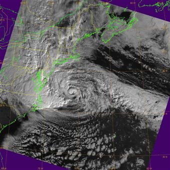
This is an infrared image of Post-Tropical Cyclone Sandy taken early Oct. 30, 2012 by the U.S. Air Force's Defense Meteorological Satellite Program Flight 14. The DMSP mission is to generate terrestrial and space weather data for operational forces worldwide, however the data from this program is also furnished to the civilian community through the Department of Commerce, thus providing more information from which forecasters can better predict pathways and intensity of storms like Sandy.
|
 |
This is an image of Hurricane Sandy prior to landfall taken Oct. 29, 2012 by the U.S. Air Force's Defense Meteorological Satellite Program Flight 18. The DMSP mission is to generate terrestrial and space weather data for operational forces worldwide, however the data from this program is also furnished to the civilian community through the Department of Commerce, thus providing more information from which forecasters can better predict pathways and intensity of storms like Hurricane Sandy.
|
 |
This is a microwave image of Hurricane Sandy prior to landfall taken Oct. 29, 2012 by the U.S. Air Force's Defense Meteorological Satellite Program Flight 18. This image shows that the storm had strengthened and developed a partial eyewall prior to landfall. The DMSP mission is to generate terrestrial and space weather data for operational forces worldwide, however the data from this program is also furnished to the civilian community through the Department of Commerce, thus providing more information from which forecasters can better predict pathways and intensity of storms like Hurricane Sandy.
|
|
|
Watching 'Sandy'
10/30/2012 - PETERSON AIR FORCE BASE, Colo. (AFNS) -- As post-tropical cyclone Sandy continues to make its way across the northeastern U.S. and Canada, U.S. Air Force Defense Meteorological Satellite Program assets continue to provide valuable weather data to forecasters across the region so they can better predict the storm's pathway and intensity.
While the DMSP mission is to generate terrestrial and space weather data for operational forces worldwide, the data from this program is also furnished to the civilian community through the Department of Commerce.
(Courtesy of Air Force Space Command Public Affairs) |
|
