Map
Richmond & vicinity.

| Format |
Map |
|---|---|
| Location |
Richmond Richmond Region United States Virginia |
| Language |
English |
| Subjects |
Landowners Richmond Richmond (Va.) Richmond Region Richmond Region (Va.) United States Virginia |
- Title
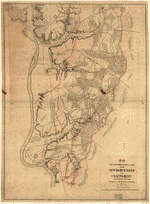
- Richmond & vicinity.
- Description
-
Relief shown by hachures.
-
Shows names of some residents.
-
Title on verso obscured by mounting.
-
Pen-and-ink and pencil on 2 pieces of tracing linen, pasted together and mounted on cloth.
-
LC Civil War maps (2nd ed.), 636
-
In pencil in lower left: 12.
-
Copy imperfect: Ink spots thoughout, and large area of liquid staining in upper right.
-
Available also through the Library of Congress Web site as a raster image.
-
1 ms. map : col., cloth ; 60 x 85 cm.
- Created Published
-
[186-]
- Subject Headings
-
-
Richmond (Va.)
-
-
Richmond Region (Va.)
-
-
Landowners--Virginia--Richmond Region
-
-
United States--Virginia--Richmond.
-
-
United States--Virginia--Richmond Region.
- Notes
-
-
Relief shown by hachures.
-
-
Shows names of some residents.
-
-
Title on verso obscured by mounting.
-
-
Pen-and-ink and pencil on 2 pieces of tracing linen, pasted together and mounted on cloth.
-
-
LC Civil War maps (2nd ed.), 636
-
-
In pencil in lower left: 12.
-
-
Copy imperfect: Ink spots thoughout, and large area of liquid staining in upper right.
-
-
Available also through the Library of Congress Web site as a raster image.
- Medium
-
1 ms. map : col., cloth ; 60 x 85 cm.
- Call Number
-
G3884.R5 186- .R5
- Repository
-
Library of Congress Geography and Map Division Washington, D.C. 20540-4650 USA dcu
- Digital Id
-
g3884r cw0636000 http://hdl.loc.gov/loc.gmd/g3884r.cw0636000
- Library of Congress Catalog Number
- 2006629147
Rights & Access
The maps in the Map Collections materials were either published prior to 1922, produced by the United States government, or both (see catalogue records that accompany each map for information regarding date of publication and source). The Library of Congress is providing access to these materials for educational and research purposes and is not aware of any U.S. copyright protection (see Title 17 of the United States Code) or any other restrictions in the Map Collection materials.
Note that the written permission of the copyright owners and/or other rights holders (such as publicity and/or privacy rights) is required for distribution, reproduction, or other use of protected items beyond that allowed by fair use or other statutory exemptions. Responsibility for making an independent legal assessment of an item and securing any necessary permissions ultimately rests with persons desiring to use the item.
More about Copyright and other Restrictions
For guidance about compiling full citations consult Citing Primary Sources.
Part of...
-
Civil War Maps
[2281]
-
Military Battles And Campaigns Cartographic Items
[3867]
-
Geography And Maps Division
[60803]
-
American Memory
[1121009]
More maps like this
-
 Map used by Jed. Hotchkiss, Top. Eng., 2d Corps, A.N. Va., in campaign of 1864 : [Richmond, Virginia region].
Contributor:
Hotchkiss, Jedediah
Site:
American Memory-cultural, Main Catalog
Original Format:
Map
Date:
1864
View catalog record
Map used by Jed. Hotchkiss, Top. Eng., 2d Corps, A.N. Va., in campaign of 1864 : [Richmond, Virginia region].
Contributor:
Hotchkiss, Jedediah
Site:
American Memory-cultural, Main Catalog
Original Format:
Map
Date:
1864
View catalog record
-
 Richmond and its defences [sic] : constructed and engraved to illustrate "The war with the South" /
Contributor:
Sholl, Charles
Site:
American Memory-cultural
Original Format:
Map
Date:
1862
Richmond and its defences [sic] : constructed and engraved to illustrate "The war with the South" /
Contributor:
Sholl, Charles
Site:
American Memory-cultural
Original Format:
Map
Date:
1862
-
 Map of a part of the city of Richmond showing the burnt districts
Contributor:
Ludwig, C. L.
Site:
American Memory-cultural
Original Format:
Map
Date:
1865
Map of a part of the city of Richmond showing the burnt districts
Contributor:
Ludwig, C. L.
Site:
American Memory-cultural
Original Format:
Map
Date:
1865
-
 [Ge]ographical sketch of the city of Richmond, Virginia, with surrounding encampments, 1862.
Contributor:
Sneden, Robert Knox
Site:
American Memory-cultural
Original Format:
Map
Date:
1861
[Ge]ographical sketch of the city of Richmond, Virginia, with surrounding encampments, 1862.
Contributor:
Sneden, Robert Knox
Site:
American Memory-cultural
Original Format:
Map
Date:
1861
-
 Map of the country between Richmond and Petersburg /
Contributor:
Gilmer, Jeremy Francis
Site:
American Memory-cultural, Main Catalog
Original Format:
Map
Date:
1864
View catalog record
Map of the country between Richmond and Petersburg /
Contributor:
Gilmer, Jeremy Francis
Site:
American Memory-cultural, Main Catalog
Original Format:
Map
Date:
1864
View catalog record
-
 Map of the Confederate lines from New Bridge road to Chafins Bluff /
Contributor:
Stevens, W. H.
Site:
American Memory-cultural, Main Catalog
Original Format:
Map
Date:
1864
View catalog record
Map of the Confederate lines from New Bridge road to Chafins Bluff /
Contributor:
Stevens, W. H.
Site:
American Memory-cultural, Main Catalog
Original Format:
Map
Date:
1864
View catalog record
-
 Region embraced in the operations of the armies against Richmond and Petersburg
Contributor:
United States. Army. Corps of Engineers
Site:
American Memory-cultural, Main Catalog
Original Format:
Map
Date:
1865
View catalog record
Region embraced in the operations of the armies against Richmond and Petersburg
Contributor:
United States. Army. Corps of Engineers
Site:
American Memory-cultural, Main Catalog
Original Format:
Map
Date:
1865
View catalog record
-
 [Military map of Richmond and vicinity] /
Contributor:
United States Coast Survey
Site:
American Memory-cultural, Main Catalog
Original Format:
Map
Date:
1864
View catalog record
[Military map of Richmond and vicinity] /
Contributor:
United States Coast Survey
Site:
American Memory-cultural, Main Catalog
Original Format:
Map
Date:
1864
View catalog record
-
 Region embraced in the operations of the armies against Richmond and Petersburg /
Contributor:
United States. Army. Corps of Engineers
Site:
American Memory-cultural, Main Catalog
Original Format:
Map
Date:
1865
View catalog record
Region embraced in the operations of the armies against Richmond and Petersburg /
Contributor:
United States. Army. Corps of Engineers
Site:
American Memory-cultural, Main Catalog
Original Format:
Map
Date:
1865
View catalog record
-
 [Seven Days' battles, Virginia, June 25-July 1, 1862] /
Contributor:
Landers, Howard Lee
Site:
American Memory-cultural, Main Catalog
Original Format:
Map
Date:
1929-01-01
View catalog record
[Seven Days' battles, Virginia, June 25-July 1, 1862] /
Contributor:
Landers, Howard Lee
Site:
American Memory-cultural, Main Catalog
Original Format:
Map
Date:
1929-01-01
View catalog record
-
 [Map of the vicinity of Richmond, north and east of the James River].
Site:
American Memory-cultural, Main Catalog
Original Format:
Map
Date:
1864
View catalog record
[Map of the vicinity of Richmond, north and east of the James River].
Site:
American Memory-cultural, Main Catalog
Original Format:
Map
Date:
1864
View catalog record
-
 Map of vicinity of Richmond /
Contributor:
Campbell, Albert H.
Site:
American Memory-cultural, Main Catalog
Original Format:
Map
Date:
1864
View catalog record
Map of vicinity of Richmond /
Contributor:
Campbell, Albert H.
Site:
American Memory-cultural, Main Catalog
Original Format:
Map
Date:
1864
View catalog record
-
 Map of the country between Richmond and Petersburg
Contributor:
Gilmer, Jeremy Francis
Site:
American Memory-cultural
Original Format:
Map
Date:
1864
Map of the country between Richmond and Petersburg
Contributor:
Gilmer, Jeremy Francis
Site:
American Memory-cultural
Original Format:
Map
Date:
1864
-
 A topographical map of the city of Richmond and vicinity : from official data /
Contributor:
Colton, G. Woolworth
Site:
American Memory-cultural, Main Catalog
Original Format:
Map
Date:
1865
View catalog record
A topographical map of the city of Richmond and vicinity : from official data /
Contributor:
Colton, G. Woolworth
Site:
American Memory-cultural, Main Catalog
Original Format:
Map
Date:
1865
View catalog record
-
 Position of Richmond, Va. /
Contributor:
Abbot, Henry L.
Site:
American Memory-cultural, Main Catalog
Original Format:
Map
Date:
1862
View catalog record
Position of Richmond, Va. /
Contributor:
Abbot, Henry L.
Site:
American Memory-cultural, Main Catalog
Original Format:
Map
Date:
1862
View catalog record
-
 Copy of section of photograph map captured from the enemy, showing country adjacent to Richmond and lines of defensive works surrounding the city. /
Contributor:
United States. Army of the Potomac. Engineer Dept
Site:
American Memory-cultural, Main Catalog
Original Format:
Map
Date:
1864
View catalog record
Copy of section of photograph map captured from the enemy, showing country adjacent to Richmond and lines of defensive works surrounding the city. /
Contributor:
United States. Army of the Potomac. Engineer Dept
Site:
American Memory-cultural, Main Catalog
Original Format:
Map
Date:
1864
View catalog record
You might also like
-

 Guide book of the city of Richmond,
Contributor:
[Kernodle, Louise Wellons (Nurney)]
Site:
Main Catalog
Original Format:
Book
Date:
1914
Guide book of the city of Richmond,
Contributor:
[Kernodle, Louise Wellons (Nurney)]
Site:
Main Catalog
Original Format:
Book
Date:
1914
-
The advantages of Richmond, Virginia, as a manufacturing and trading centre, with notes for the guidance of tourists ...
Contributor:
James, George Watson
Site:
Main Catalog
Original Format:
Book
Date:
1882
-
The advantages of Richmond, Virginia, as a manufacturing and trading centre,
Site:
Main Catalog
Original Format:
Book
Date:
1882
-
Richmond: an illustrated hand-book and guide with notices of the battle-fields.
Contributor:
Poindexter, Charles
Site:
Main Catalog
Original Format:
Book
Date:
1896
-
Richmonnd, Va. A guide to and description of its principal and places and objects of interest.
Contributor:
Murphy, Daniel
Site:
Main Catalog
Original Format:
Book
Date:
1881
-
 The recollections of a Virginia newspaper man ,
Contributor:
Ezekiel, Herbert T.
Site:
American Memory-cultural, Main Catalog
Original Format:
Book
Date:
1920
View catalog record
The recollections of a Virginia newspaper man ,
Contributor:
Ezekiel, Herbert T.
Site:
American Memory-cultural, Main Catalog
Original Format:
Book
Date:
1920
View catalog record