
Magnitude 6.7 - OFFSHORE VALPARAISO, CHILE
This webpage is being phased out and is no longer maintained. Please use the new Real-time Earthquake Map instead and update your bookmark. See Quick Tips & User Guide.
2012 April 17 03:50:16 UTC
Earthquake Details
- This event has been reviewed by a seismologist.
| Magnitude | 6.7 |
|---|---|
| Date-Time |
|
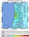
| Location | 32.701°S, 71.484°W |
| Depth | 37 km (23.0 miles) |
| Region | OFFSHORE VALPARAISO, CHILE |
| Distances | 42 km (26 miles) NNE of Valparaiso, Valparaiso, Chile 81 km (50 miles) W of Los Andes, Valparaiso, Chile 101 km (62 miles) N of San Antonio, Valparaiso, Chile 112 km (69 miles) NW of SANTIAGO, Region Metropolitana, Chile |
| Location Uncertainty | horizontal +/- 14.6 km (9.1 miles); depth +/- 2.8 km (1.7 miles) |
| Parameters | NST=496, Nph=501, Dmin=90.2 km, Rmss=0.93 sec, Gp= 29°, M-type=(unknown type), Version=G |
| Source |
|
| Event ID | usc00095a2 |
- Did you feel it? Report shaking and damage at your location. You can also view a map displaying accumulated data from your report and others.
Earthquake Summary


Felt Reports
One person died of a heart attack in Quillota and one person killed at Papudo. Minor damage to buildings at Valparaiso. Rockslides reported at Santiago.
Earthquake Maps


- Preliminary Earthquake Report
- U.S. Geological Survey, National Earthquake Information Center:
World Data Center for Seismology, Denver
