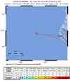
Magnitude 5.2 - OFFSHORE NORTHERN CALIFORNIA
This webpage is being phased out and is no longer maintained. Please use the new Real-time Earthquake Map instead and update your bookmark. See Quick Tips & User Guide.
2012 July 21 06:04:21 UTC
Earthquake Details
- This event has been reviewed by a seismologist.
| Magnitude | 5.2 |
|---|---|
| Date-Time |
|
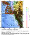
| Location | 40.412°N, 125.331°W |
| Depth | 6.1 km (3.8 miles) |
| Region | OFFSHORE NORTHERN CALIFORNIA |
| Distances |
|
| Location Uncertainty | horizontal +/- 2.5 km (1.6 miles); depth +/- 2.7 km (1.7 miles) |
| Parameters | Nph= 44, Dmin=85 km, Rmss=0.18 sec, Gp=252°, M-type=regional moment magnitude (Mw), Version=C |
| Source | |
| Event ID | nc71819471 |
- Did you feel it? Report shaking and damage at your location. You can also view a map displaying accumulated data from your report and others.