
Elusive El Niño challenges NOAA’s 2012 U.S. Winter Outlook
October 18, 2012

Download here. (Credit: NOAA)
The western half of the continental U.S. and central and northern Alaska could be in for a warmer-than-average winter, while most of Florida might be colder-than-normal December through February, according to NOAA’s annual Winter Outlook announced today from the agency’s new Center for Weather and Climate Prediction in College Park, Md.
Forecasters with NOAA’s Climate Prediction Center say a wavering El Niño, expected to have developed by now, makes this year’s winter outlook less certain than previous years.
“This is one of the most challenging outlooks we’ve produced in recent years because El Niño decided not to show up as expected,” said Mike Halpert, deputy director of NOAA’s Climate Prediction Center. “In fact, it stalled out last month, leaving neutral conditions in place in the tropical Pacific.”
When El Niño is present, warmer ocean water in the equatorial Pacific shifts the patterns of tropical rainfall that in turn influence the strength and position of the jetstream and storms over the Pacific Ocean and United States. This climate pattern gives seasonal forecasters confidence in how the U.S. winter will unfold. An El Niño watch remains in effect because there’s still a window for it to emerge.
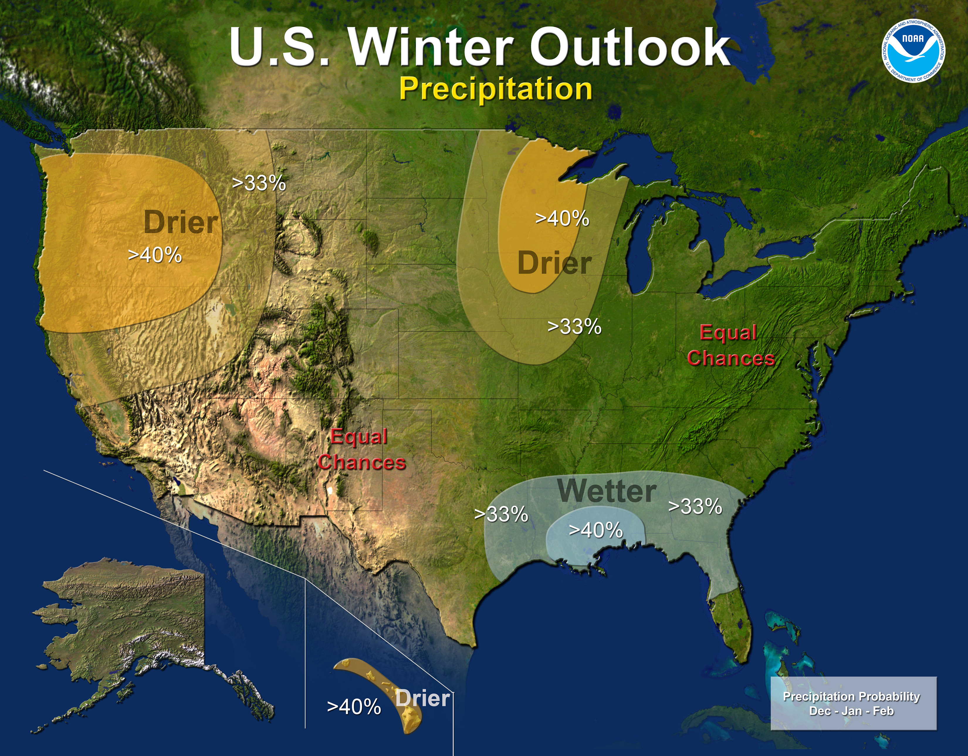
Download here. (Credit: NOAA)
Other climate factors can influence winter weather across the country. Some of these factors, such as the North Atlantic Oscillation, a prominent climate pattern, are difficult to predict more than one to two weeks in advance. The NAO adds uncertainty to the winter outlook in the Northeast and Mid-Atlantic portions of the country.
Areas ravaged by extreme drought over the past year are unlikely to see much relief from drought conditions this winter.
In the 2012 U.S. Winter Outlook (December through February) odds favor:
- Warmer-than-average temperatures in much of Texas, northward through the Central and Northern Plains and westward across the Southwest, the Northern Rockies, and eastern Washington, Oregon and California, as well as the northern two-thirds of Alaska.
- Cooler-than-average temperatures in Hawaii and in most of Florida, excluding the panhandle.
- Drier-than-average conditions in Hawaii, the Pacific Northwest and Northern California, including Idaho, western Montana, and portions of Wyoming, Utah and most of Nevada.
- Drier-than-average conditions in the upper Midwest, including Minnesota, Wisconsin, Iowa and northern Missouri and eastern parts of North and South Dakota, Nebraska, Kansas, and western Illinois.
- Wetter-than-average conditions across the Gulf Coast states from the northern half of Florida to eastern Texas.
The rest of the country falls into the “equal chance” category, meaning these areas have an equal chance for above-, near-, or below-normal temperatures and/or precipitation.
This seasonal outlook does not project where and when snowstorms may hit or provide total seasonal snowfall accumulations. Snow forecasts are dependent upon the strength and track of winter storms, which are generally not predictable more than a week in advance.
NOAA's National Weather Service is the primary source of weather data, forecasts and warnings for the United States and its territories. NOAA’s National Weather Service operates the most advanced weather and flood warning and forecast system in the world, helping to protect lives and property and enhance the national economy. Working with partners, NOAA’s National Weather Service is building a Weather-Ready Nation to support community resilience in the face of increasing vulnerability to extreme weather. Visit us online at weather.gov and on Facebook.
NOAA’s mission is to understand and predict changes in the Earth's environment, from the depths of the ocean to the surface of the sun, and to conserve and manage our coastal and marine resources. Visit us at www.noaa.gov and join us on Facebook, Twitter and our other social media channels.