|
 | | |
In the Spotlight ...

For the latest fire information: |
| |
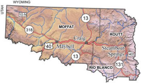
Click on the map above for additional information
|
|
|
Motorized Travel Limited to Existing Roads and Trails in Little Snake
With hunting season upon us, the Bureau of Land Management's Little Snake Field Office is reminding the public that motorized-use within the majority of its boundaries in Moffat, Routt and northern Rio Blanco counties is now limited to existing roads and trails unless otherwise posted. Some areas within the field office are closed to all motorized travel, including all Wilderness Study Areas; the Serviceberry, Fly Creek, and Emerald Mountain Special Recreation Management Areas; the Maybell Uranium Pit; and the Irish Canyon Area of Critical Environmental Concern. To continue to provide the opportunity for off-road recreation, the field office specifically manages nearly 20,000 acres in the South Sand Wash Basin as an area open to off-road motorized use.
|
Fire Restrictions Rescinded on Federal Lands in Moffat and Rio Blanco Counties
This morning, federal, state and county officials revisited fire conditions across northwest Colorado. Northwest Colorado Fire Management Unit Fire Management Officer, Colt Mortenson, evaluated criteria such as live fuel moistures, drought indexes, available resources, and number of human caused fires to determine if fire restrictions are necessary. After reviewing the information, federal land managers decided to rescind all fire restrictions on Bureau of Land Management, Dinosaur National Monument, and Browns Park National Wildlife Refuge public lands in Moffat and Rio Blanco Counties as of 12:01 a.m., September 14, 2012. Click here to view the entire news release .
Oil & Gas Lease Sale Assessment for Lands in Moffat, Routt & Rio Blanco Counties
Updated BLM Maps now Available
The Canyon of Lodore, Meeker, Steamboat Springs & Walden 2012 maps are now available to purchase. Please ensure you have the latest version when heading out to enjoy your public lands! Click here for purchasing information.
National Greater Sage-Grouse Planning Strategy
Reclamation Plan Template
This is a draft template for the voluntary use by industry. Send any comments to: Dave Rosenkrance, Assistant District Manager
Northwest Colorado District
2815 H Road
Grand Junction, CO 81506
(970) 244-3000 Comments need to be received by October 14, 2012.
BLM Issues Final Decision for the Little Snake Management Plan

The Bureau of Land Management today released the Record of Decision for the Little Snake Resource Management Plan in northwestern Colorado. The Record of Decision is the final step of an extensive, multi-year effort to develop a Resource Management Plan for approximately 1.3 million acres of BLM-administered public lands and an additional 1.1 million acres of subsurface mineral estate administered by the Little Snake Field Office in Moffat, Routt, and Rio Blanco counties.
|
BLM Plan Proposes Balanced Management, Responsible Oil and Gas Leasing in NW Colorado, and Protection of Vermillion Basin
The Bureau of Land Management announced today that its upcoming Proposed Resource Management Plan for the Little Snake Field Office in northwestern Colorado would continue to allow oil and gas development on most of the lands and minerals managed by the Field Office, but would protect the 77,000-acre Vermillion Basin from energy development.
|
|
|
Bureau of Land Management in Northwest Colorado...The Little Snake Field Office encompasses 4.2 million acres of federal, state and private lands in Moffat, Routt, and Rio Blanco counties. Of the total area, 1.3 million acres are public lands administered by the Bureau of Land Management and 1.1 million acres of the private and state lands are underlain by federally owned minerals. Resource activities include: wildlife, cultural resources, grazing, energy & minerals, rights-of-ways, paleontological resources and recreation. For more information, click here or on "Programs" from the menu above. Take a photo tour of Little Snake
Wendy Reynolds, Field Manager Phone: 970-826-5000 | Fax: 970-826-5002 | Office Hours: 7:45 am – 4:30 pm M-F
|