|
NEWS:
|
New Product

|
|
New Product

|
|
|
|
THREE MAJOR EARTHQUAKES STRIKE PACIFIC BASIN IN A NINE-DAY PERIOD
Three major earthquakes struck Central America and the Philippines from 27 August - 5 September 2012. Notable were the 27 August El Salvador earthquake (Mw 7.3) in which PTWC issued a Fixed Regional Warning; the 31 August East Philippine earthquake (Mw 7.6) in which PTWC issued an Expanding Regional Warning; and the 5 September Costa Rica earthquake (Mw 7.6) in which PTWC issued a Fixed Regional Warning. Tsunamis were measured in these events, with damage and injuries reported from the El Salvador event.
The El Salvador M 7.3 earthquake occurred on 27 August 2012 at 04:37 UTC at a depth of 131 km as a result of thrust faulting on or near the subduction zone interface between the Cocos and Caribbean plates. A maximum 36 cm amplitude tsunami was measured in Baltra, Ecuador.  El Salvador preliminary maximum inland inundation was reported at 300 meters and maximum runup heights at 5 meters. Coastal flooding was also reported in Nicaragua. In the aftermath of the event, the Intergovernmental Oceanographic Commission (IOC) and ITIC were requested to coordinate post tsunami survey assessments and help improve capabilities of El Salvador to respond to future events. Post-tsunami surveys are essential for scientists to understand tsunamis and to evaluate potential improvements to forecasting models used by tsunami warning centers. NOAA's Pacific Tsunami Warning Center (PTWC) in Hawaii provides warning information to El Salvador and other countries throughout the Pacific. PTWC will benefit greatly from understanding how their predictions corresponded with the recent event field measurements. Post-tsunami survey methodology has improved in recent years with ITIC working closely with the IOC to develop a recently published manual to standardize the practice. (Photo credit: Dr. Hermann Fritz, Georgia Institute of Technology) El Salvador preliminary maximum inland inundation was reported at 300 meters and maximum runup heights at 5 meters. Coastal flooding was also reported in Nicaragua. In the aftermath of the event, the Intergovernmental Oceanographic Commission (IOC) and ITIC were requested to coordinate post tsunami survey assessments and help improve capabilities of El Salvador to respond to future events. Post-tsunami surveys are essential for scientists to understand tsunamis and to evaluate potential improvements to forecasting models used by tsunami warning centers. NOAA's Pacific Tsunami Warning Center (PTWC) in Hawaii provides warning information to El Salvador and other countries throughout the Pacific. PTWC will benefit greatly from understanding how their predictions corresponded with the recent event field measurements. Post-tsunami survey methodology has improved in recent years with ITIC working closely with the IOC to develop a recently published manual to standardize the practice. (Photo credit: Dr. Hermann Fritz, Georgia Institute of Technology)
The East Philippine M 7.6 earthquake occurred on 31 August 2012 at 12:48 UTC at a depth of 35 km as a result of reverse faulting within the oceanic lithosphere of the Philippine Sea Plate. Preliminary location of the earthquake indicates this was an intraplate event, 50 or more km to the east of the subduction zone plate boundary between the Philippine Sea and Sunda plates. A maximum 12 cm amplitude tsunami was measured further north at Omaezaki, Japan.
The Costa Rica M 7.6 earthquake occurred on 5 September 2012 at 1442 UTC at a depth of 40 km as a result of thrust faulting on or near the subduction zone interface also between the Cocos and Caribbean plates. A maximum 15 cm amplitude tsunami was measured at Galapagos, Ecuador. PTWC initially issued a Caribbean Tsunami Watch, which was immediately withdrawn when the earthquake location was reevaluated to be on the Pacific side of Costa Rica. PTWC then issued a Pacific Fixed Regional Tsunami Warning.
 |
|
 |
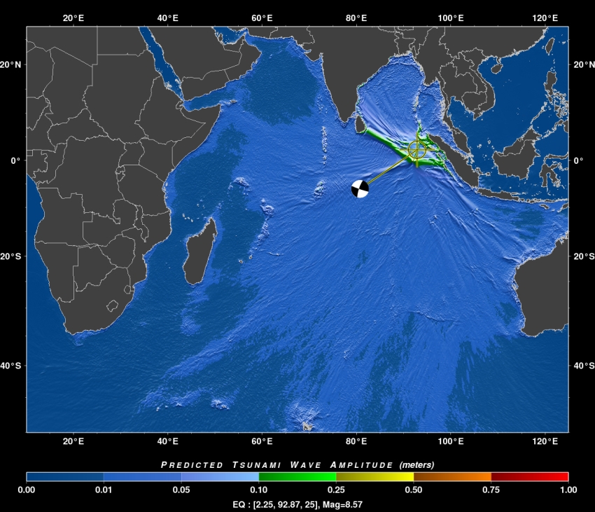
Captions: Left: PTWC RIFT model simulation showing the predicted coastal tsunami wave amplitudes from the 27 August 2012 thrust earthquake.
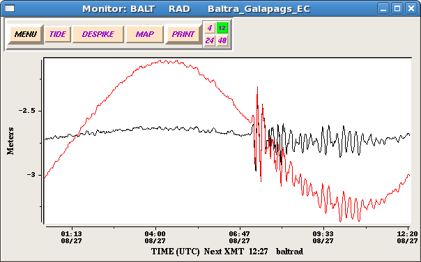
Right top: Although only a very small tsunami (0.1 m amplitude) was recorded on Acajutla, El Salvador sea level station, a much larger tsunami (0.4 m) was observed at Baltra, Galapagos Islands, Ecuador (PTWC).
Right bottom: DART 43413 deep-ocean instrument off Mexico recorded a 1 cm tsunami (PTWC).
|
|
|
M8.6 EARTHQUAKE GENERATES LOCAL TSUNAMI IN INDONESIA, 11 APRIL 2012
A M8.6 shallow strike-slip earthquake occurred at 0838 UTC 11 April 2012 off the coast of northern Sumatra, Indonesia, and was followed by a second shallow M8.2 strike-slip aftershock at 1043 UTC (USGS). Both generated small local tsunamis with a maximum of 1.06 m measured at 1007 UTC in Meulaboh, Indonesia located about 395 km west southwest of the epicenter. Waves heights up to 0.4 m were recorded throughout the region and as far away as Rodrigues Island, Mauritius in the western Indian Ocean (0.22 m wave amplitude). Amateur video of the tsunami arriving in Indonesia was captured.
Since October 2011, Regional Tsunami Service Providers (RTSP) of Australia, India and Indonesia have been serving as the primary sources for tsunami advisories for the Indian Ocean, with the PTWC and Japan Meteorological Agency (JMA) continuing to operate a parallel service until the end of 2012. The RTSP provide tsunami alerts directly to national tsunami warning centers in each country, and the countries use the advice to assess and issue warnings and advisories to their populations. The PTWC issued an Indian-Ocean wide Tsunami Watch at 0845 UTC, and JMA issued Tsunami Watch Information at 0855 UTC. PTWC cancelled its tsunami watch at 1318 UTC.
Public bulletins are available from the Australia, India, and Indonesia RTSPs, and from the PTWC.
This region of the Indo-Ausralian plate has been seismically very active throughout history, and includes the great M9.1 earthquake of 26 December 2004 that generated the deadliest tsunami ever killing nearly 230,000 in Indonesia and across the Indian Ocean. Immediately following the disaster, the IOC of UNESCO took the lead in coordinating activities and immediate action to establish an Indian Ocean Tsunami Warning and Mitigation System (IOTWS). The response included the start of an interim Advisory Service in 2005 through the PTWC in Hawaii and the JMA in Tokyo, and in 2011 the start of the permanent RTSPs for the Indian Ocean.
 |

|
 |
Captions: Left: PTWC RIFT model simulation showing the predicted maximum off-shore tsunami wave amplitudes from the 0838 MTC 11 April 2012 strike-slip earthquake.
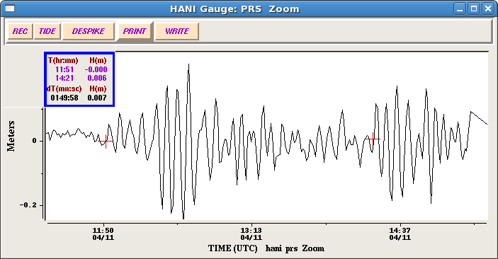
Right top: Tsunamis recorded on the Hanimaadhoo, Maldives coastal sea level gauge (PTWC). The 1st tsunami (0.23 m amplitude) was generated by the M8.6 0838 UTC earthquake and the 2nd tsunami (0.18 m amplitude) was generated by the M8.2 1043 UTC earthquake.
Right bottom: DART 23401 deep-ocean instrument in the Bay of Bengal clearly shows the 2 tsunamis (WC/ATWC)
|
|
|
|
 UNESCO
 IOC
IOC
 NOAA
NOAA


 TsunamiTeacher