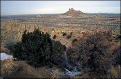
Angel Peak Scenic Area, located about 30 miles southeast of Farmington, offers more than 10,000 acres of rugged terrain recognized for its scenic and scientific wonders. The nearly 7,000-foot Angel Peak, a landmark composed of river deposited sandstone from the San Jose Formation, is visible for miles in any direction. However, the banded colors of the badlands and the deep sculpted fingers of the canyon at the base of Angel Peak are only fully revealed to those who make the short journey along the rim.
The panoramic view of the canyon offers the visitor a spectacular glimpse into the earth’s past. This landscape etched by time, has been more than 60 million years in the making, and the geology of the area is as important to understanding the evolution of mammals, as it is spectacular to view.
Deeply eroded sandstone-capped mesas and slope-forming mudstones of the Nacimiento Formation tell a story of a past where high-energy rivers deposited hundreds of meters of rock material shed from the Rocky Mountains to the north, across the San Juan Basin. These rivers carved their way through a landscape of large grasslands, marshes, lakes, and forests where the explosion of mammal evolution was occurring.
The age of reptiles ended with a massive extinction, finishing off the Dinosaurs at the end of the Cretaceous period. The mammals, having survived the extinction event began to radiate, filling the void in the web of life left by the dinosaurs’ demise. Various species of fish, lizards, turtles, crocodiles, and rodents, as well as dog, cat, and cow-sized mammals, once called the Angel Peak area home.
Remnants of these mammals' fossils, as well as wood petrified over the ages, can be found eroding out of the sandstone, siltstone, and mudstone visible in the canyon today. Collection and study of these important fossils by permitted paleontologists helps document the evolution of many mammal species and contributes to our knowledge of the earth’s history.
Activities
Hiking, photography, watchable wildlife, camping, picnicking.
While formal hiking trails in the area are limited, dispersed hiking opportunities abound along the rim.
Facilities
Three picnic areas and a campground are located along the canyon rim overlooking Angel Peak and the Kutz Canyon badlands. Three picnic areas (Sage, Castle Rock, and Cliffs), containing seven developed sites, are located along the rim road. Each site has a shelter, tables on a concrete underfoot, a gravel pathway, and a fire grate. Trash cans are located in all three picnic areas. Accessible vault toilets are available at both Sage and Cliffs picnic areas.
Angel Peak Campground has nine sites available for tent camping; each with picnic tables on a concrete underfoot, gravel pathways, and fire grates. Picnic shelters are located at three campsites; two with single shelters and one with a double shelter suitable for larger groups. Two accessible vault toilets and trash receptacles are conveniently located in the campground. A short nature trail winds among the plants that have found a niche along the desolate rim and leads to an overlook of the canyon where a bench is provided for relaxing and enjoying the view.
No electrical hookups or water is available.
Location / Access
Access to the Angel Peak Scenic Area is off US Highway 550, 15 miles south of Bloomfield on County Road 7175. Follow the gravel road along the canyon rim for approximately six miles to reach the campground, or stop at one of three developed picnic areas along the way to enjoy the view or have a bite to eat. It is important to note the gravel road may become impassible in bad weather.
Safety
The area is subject to seasonal extremes and visitors should be prepared for changing weather; it can get cold in the winter, hot in the summer, and is prone to strong spring breezes. Always plan ahead, be prepared for weather changes and carry plenty of water.
The stark, barren landscape at Angel Peak provides the perfect home for a variety of desert inhabitants including rattlesnakes. Be aware of your surroundings and watch where you walk; both you and the snakes will benefit!
Active gas wells exist in the Angel Peak Scenic Area. Be safe and stay away from well pads, pipelines, and other oilfield equipment. Watch for traffic and heavy trucks.