The NCA consists of 62,844 acres of public land managed by the BLM Uncompahgre Field Office under the 2004 Gunnison Gorge National Conservation Area Resource Management Plan (9.2MB download). Initially designated through the Black Canyon of the Gunnison National Park and Gunnison Gorge National Conservation Area Act of 1999 (Public Law 106-76), the Black Canyon of the Gunnison Boundary Revision Act of 2003 (Public Law 108-78) expanded the NCA from 57,725 acres to its current size.
GUNNISON GORGE WILDERNESS AREA
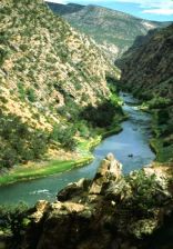
Within the NCA, the Gunnison Gorge Wilderness Area encompasses approximately 17,784 acres of public land, including a fourteen-mile stretch of the Gunnison River extending from the northwestern boundary of the Black Canyon of the Gunnison National Park north to a point approximately one mile downstream from the confluence of the Smith Fork and the main stem of the Gunnison.
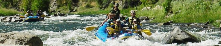
The wilderness area is managed to preserve and protect outstanding wilderness, scenic, and non-motorized recreational values. The Gunnison Gorge offers a technical (Class II-IV) and remote boating experience for rafters, kayakers, and whitewater canoeists. Boating conditions change with flows and are highly dependent on winter snowpack. Other wilderness uses include:
Day-use and camping recreational user fees are charged in the wilderness area. The Gorge was one of the BLM’s first recreational fee demo pilots and has been charging fees since 1997. A major use of fees is the control of tamarisk and other invasive species throughout the wilderness area.

RECREATION
The diverse landscape within the NCA supports an equally diverse range of activities, including wilderness whitewater boating and Gold Medal trout fishing on the Gunnison River, big-game hunting for mule deer and elk, motorized and non-motorized recreation, domestic sheep and livestock grazing, sightseeing, wildlife photography, and wilderness hiking and backpacking.
River Flows
Cick here for real-time information on river flows through the Gunnison Gorge from the U.S. Geological Survey.
CULTURAL RESOURCES
The NCA contains a number of prehistoric and historic sites, including rock art, cabins, campsites, and mines. A number of these sites are eligible for listing on the National Register of Historic Places. Cultural surveys of the area are ongoing, as are a number of site stabilization projects. A major goal of the NCA resource management plan is to provide users with enhanced interpretation of the area’s outstanding cultural resources in order to increase awareness and understanding of the need to protect these areas.
RANGELAND MANAGEMENT
Approximately 5,644 animal unit months of cattle and sheep grazing occur on eleven allotments throughout the NCA. Grazing permits in the NCA contain special stipulations requiring a visual setback for livestock grazing activities (such as bedding grounds, water sites, and supplemental feed sites) of 500 feet from established recreational sites (including roads, trailheads, user areas, and fee collection sites).
FIRE MANAGEMENT
The UFO is part of the Montrose Interagency Fire Management Unit, made up of the Grand Mesa, Uncompahgre, and Gunnison National Forests, Black Canyon of the Gunnison National Park, and Currecanti National Recreation Area. The UFO averages about 85 fires a year, with lightning igniting approximately 95 percent of these and humans causing the rest. There are eight fire engines in the unit available to respond to fires in the UFO. On average, the UFO implements three prescribed fires per 600 acres.
WILDLIFE AND SPECIAL STATUS SPECIES
The NCA supports a variety of upland, riparian, and aquatic wildlife species and habitats. Common species include mule deer, elk, mountain lion, coyote, ringtail cats, small mammals, neo-tropical birds, raptors, chukar, and river otter. Because of its excellent trout population, including rainbow, brown, and cutthroat, the Gunnison River is designated as a Gold Medal Trout Fishery by the Colorado Division of Wildlife.
Sensitive species in the NCA include: clay-loving buckwheat, Montrose penstemon, Rocky Mountain thistle, Delta lomatium, Unita Basin hookless cactus, wintering bald eagles, spotted bats, river otters, and kit foxes (Colorado Sensitive species). The east side of the NCA contains a small population of 200-300 Gunnison sage-grouse that are managed under the 1998 Crawford Sage-Grouse Partnership Conservation Plan. The 2004 NCA plan designates three Areas of Critical Environmental Concern (ACEC): the Native Plant Community ACEC, Fairview ACEC (sensitive Mancos Shale plant species) and the Gunnison Sage Grouse ACEC/Important Bird Area.
LANDS AND MINERALS
All forms of land appropriation, entry, and disposal are prohibited in the NCA and Wilderness. Right-of-way applications for the NCA are decided on a case-by-case basis. Acquisitions are addressed as opportunities arise on a case-by-case basis with willing sellers.
Federal mineral estate in the NCA and Wilderness is withdrawn from any form of mineral entry, location, and patent under the mining laws, except for valid existing rights. There are eight mining claims in the NCA that require validity testing.