

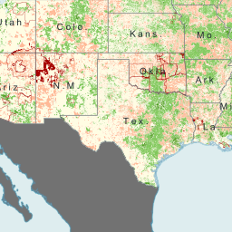
Section 706 Mobile Deployment Map
This map was created by the FCC to illustrate the Commission’s mobile deployment results found in the Eighth Broadband Progress Report, which uses data underlying the National Broadband Map, as of June 30, 2011. It shows census block areas of the United States with access to mobile services of at least 3 Mbps download ...
Section 706 Fixed Broadband Deployment Map
This map was created by the FCC to illustrate the Commission’s broadband deployment results found in the Eighth Broadband Progress Report, which uses data underlying the National Broadband Map, as of June 30, 2011. It shows census block areas of the United States with and without access to fixed broadband of 3 Mbps download ...
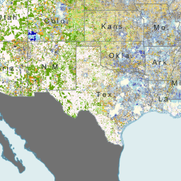
ABC Coalition FTTP Cost Model
This map shows the forward-looking cost of a fiber-to-the-premises (FTTP) broadband deployment, as estimated by a large publicly available cost model. This model takes into account the location of current broadband and telecommunications infrastructure as well as the current count of residential and business locations. The map shows the range of the total ...
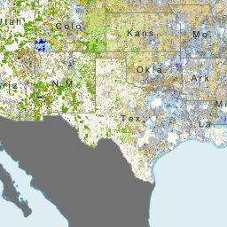
ABC Coalition FTTD Cost Model
This map shows the forward-looking cost of a green-field DSL (also called a fiber-to-the-DLC or FTTD) broadband deployment, as estimated by a large publicly available cost model. This model takes into account the location of current broadband and telecommunications infrastructure as well as the current count of residential and business locations. The map shows the ...

Rural Health Care Pilot Program
This map shows participants in the FCC's Rural Health Care Pilot Program who have received commitments for funding as of January 2012. Green and Red triangles depict entities that are health care providers eligible for Pilot Program support under the Communications Act of 1934. The map also shows health care providers who are not ...
Connect America Fund (CAF) Phase I
This map shows the 37 States where new broadband will be deployed as a result of the first phase of the Connect America Fund. The amount of funding by State and number of locations receiving support can be show by moving your mouse over each State. The Connect America Fund aims to connect 7 million ...
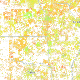
Wireline Maximum Advertised Download Speed
This map shows the maximum advertised download speed by any wireline broadband provider for each US Census block less than 2 square miles. Source: National Broadband Map as of June 2011.

Mobility Fund Phase 1 Eligible Areas
This map shows the areas identified as eligible for Mobility Fund Phase 1 support as of September 2012. These areas are US Census blocks that lack 3G or better mobile coverage at the centroid of the block and contain road miles in any of six road categories. These blocks were identified by analyzing US Census ...
800 MHz Cellular – B Block CGSAs
This map shows the Cellular Geographic Service Area (CGSA) boundaries overlaid on top of Cellular Market Areas (CMAs) for the B Block 800 MHz cellular licenses. The purpose of this map is to depict the licensed CGSAs in each CMA (as of January 11, 2012) as the FCC considers a rulemaking to revise the licensing ...

800 MHz Cellular – A Block CGSAs
This map shows the Cellular Geographic Service Area (CGSA) boundaries overlaid on top of Cellular Market Areas (CMAs) for the A Block 800 MHz cellular licenses. The purpose of this map is to depict the licensed CGSAs in each CMA (as of January 11, 2012) as the FCC considers a rulemaking to revise the licensing ...