 Pacific Crest National Scenic Trail
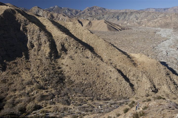
 Zigzagging its way from Mexico to Canada, the 2,650-mile Pacific Crest Trail was designated as a National Scenic Trail by Congress in 1968. The BLM manages 180-miles of the Pacific Crest National Scenic Trail, primarily in the south half of the state. This trail boasts some of the greatest elevation changes in the National Scenic Trail System and is popular with thousands of hiker and equestrian users. Whether you visit for a few hours or for a few weeks, you'll surely find a uniquely Californian scene that will rejuvenate, inspire, and surprise you.
The Pacific Crest trail crosses four designated wildernesses - the Bright Star, Kiavah, Owens Peak and Domelands. Elevations range from 4,000 feet in the south at Tylerhorse Canyon to 7,600 feet in the north at Bear Mountain. Temperatures in the summer months can range from 32°F. to over 100°F. Summer thunderstorms are common, bringing lightning and the possibility of flash floods on some segments of the trail. Winters can be bitterly cold, however, this section of the PCNST is usually free of snow by the middle of May. Sudden and severe storms can occur from September through May at any location above 6,000 feet in elevation. Expect strong winds in the spring and fall, especially on the Cameron Ridge and Cache Peak segments of the trail. Wind speeds of 60 to 80 miles per hour are common!
Water is scarce along this arid 120 mile stretch of trail, and the water you do find may not be fit for human consumption - always chemically treat or filter water. If possible, pack your own drinking water.
Wilderness permits are not currently required to travel on the BLM segments of the PCNST. A California Campfire Permit is required by the BLM, Forest Service, and the California Department of Forestry and Fire Prevention if you plan on using a campfire. These can be obtained at any of the agency offices listed on this flyer.
The Pacific Crest National Scenic Trail is a component of the National Landscape Conservation System.
DESERT SEGMENT
This section is managed by the BLM, Ridgecrest Field Office, located at 300 S. Richmond Rd., Ridgecrest, CA 93555, telephone (760) 384-5400.
Trail Location: From Tylerhorse Canyon north of SR 178 and north to the intersection of Cameron Road and the Tehachapi-Willow Springs Road.
Mileage: 18.0 miles
Water: None; 0.2 miles south of the intersection of Cameron Road and the Tehachapi - Willow Spring Rd. - this stream is not a reliable water source, especially in drought years.
Description: Mojave Desert; pinyon-juniper woodland; several large electricity generating wind turbines are adjacent to the trail.
CAMERON RIDGE SEGMENT
This section of the Trail is managed by the BLM, Ridgecrest Field Office, located at 300 S. Richmond Rd., Ridgecrest, CA 93555, telephone (760) 384-5400.
Trail Location: The intersection of Cameron Road and the Tehachapi-Willow Springs Road, north to the Cameron Road Overpass at SR 58. After descending the switchbacks to Cameron Road, the route follows the road for 1.1 miles, and then crosses over State Highway 58.
Mileage: 7.0 miles.
Water: None
Description: Mojave Desert; Joshua trees, several large electricity generating wind turbines are adjacent to the trail.
Note: This trail segment traverses private land and the public is advised not to trespass from the 30 foot wide trail easement.
CACHE PEAK SEGMENT
This section is managed by the BLM, Ridgecrest Field Office, located at 300 S. Richmond Rd., Ridgecrest, CA 93555, telephone (760) 384-5400.
Trail Location: From the Cameron Road Overpass on SR 58 (approximately 10.0 miles east of Tehachapi, Ca.), this segment heads north to the boundary of the Sequoia National Forest in the Piute Mountains.
Mileage: 33.5
Water: Golden Oaks Springs, 16.0 miles north of SR 58. This spring is adjacent to the trail on private land - be sure to filter or chemically treat water.
Trail Description: Semi-desert chaparral in the south and graduating to oak woodland, grey pine, pinyon-juniper woodland, and Jeffrey pine.
Note: Sections of this segment cross private land, trail users are reminded not to trespass beyond the 30 foot wide trail easement in these sections.
PIUTE MOUNTAIN SEGMENT
This 10.4 mile segment is managed by the USDA, Forest Service, Sequoia National Forest, Greenhorn Ranger District, located at the Lake Isabella Visitor Center, P. O. Box 3810, Lake Isabella, CA 93240, telephone (760) 379-5646. A satellite information center is co-located at the Bakersfield Field Office located at 3801 Pegasus Dr., Bakersfield, CA, telephone (661) 391-6000.
DOVE SPRINGS SEGMENT
This section is managed by the BLM, Ridgecrest Field Office, 300 S. Richmond Rd., Ridgecrest, CA 93555, telephone (760) 384-5400.
Trail Location: From the Piute Mountain Road at Landers Meadow in the Piute Mountains of the Sequoia National Forest, the trail heads north to Bird Spring Pass in the Scodie Mountains.
Mileage: 20.0 miles
Water: None (a water spigot and cattle trough is located 1.5 miles from the trail at Willow Spring). Chemically treat or filter water from this source.
Description: Mojave Desert, Joshua tree and pinyon juniper woodland.
 SCODIE SEGMENT
This 17.6 mile segment is managed by the USDA, Forest Service, Sequoia National Forest, Cannell Meadow District, P.O. Box 6, Kernville, CA 93238, telephone (760) 376-3781.
This section is managed by the BLM, Bakersfield Field Office, located at 3801 Pegasus Dr., Bakersfield, CA 93308, telephone (661) 391-6120.
Trail Location: From SH 178 at Walker Pass, the trail heads north to the Sequoia National Forest boundary at Rockhouse Basin in the Domelands Wilderness.
Mileage: 41.0 miles.
Water: Water is no longer available at the Walker Pass Trailhead/Campground (Highway 178;) an alternate water source is from a nearby spring development located 1/10 mile west on Highway 178, in the bottom of the drainage by the 30 mph sign. Look for the square cement structure. Toilet, parking, fire grates, hitching racks and corrals are available.
Chimney Creek Campground - A well with potable water should be running from April through September. Please bring your own water when the well is off. Toilets, parking and fire grates are available.
Fox Mill Spring - There is no longer any water at Fox Mill Spring.
Spanish Needles Creek - There are small springs and streams in the Spanish Needles area.
Notice: Some water sources, such as the non-well water at Chimney Creek Campground, the water at Joshua Tree Spring, and other sources, contain naturally occurring uranium and may not be available for human consumption.
Description: Elevations range from 5,300 feet at Walker Pass to 7,600 feet on Bear Mountain; rugged terrain with frequent rockslides and talus slopes, pinyon juniper woodland; white fir and Jeffrey pine. Snow may remain on trail sections on north-facing slopes above 6,000 feet until May in heavy winter years. Due to frequent rock slides, equestrians should check local conditions before planning to ride through the Owens Peak Segment. Only experienced riders and seasoned trail horses should use this segment - several sections have vertical drops adjacent to the trail.
These trail segments are maintained through the generous support of volunteers from the Pacific Crest Trail Association. If you would like to put something back into the trail by volunteering contact the Pacific Crest Trail Association, 5325 Elkhorn Blvd., Suite 256, Sacramento, CA 95842. 1 (888) 728-7245, or check their web site at: http://www.pcta.org
And remember to Leave No Trace by practicing the following minimum impact principles:
- Plan ahead and prepare
- Camp and travel on durable surfaces
- Pack it in, pack it out
- Properly dispose of what you can't pack out
- Leave what you find
- Minimize the use and impact of fires