Marine Accident Brief
Collision of Tugboat/Barge Alliance/MMI 3024 with Tankship Naticina, Texas City Channel and Gulf Intracoastal Waterway
near Galveston, TX
August 17, 2011
NTSB Number: MAB-12-01
Adopted: April 14, 2012
PDF
| Vessel, Flag | UTV Alliance, United States | MMI 3024, United States | M/V Naticina, Marshall Islands |
| Owner, Operator | Higman Barge Lines, Inc. | Higman Barge Lines, Inc. | Owned by Front Loki, Inc. Chartered by Shell International Trading and Shipping Company Limited (STASCO) Operated by STASCO Ship Management |
| Property Damage | None | $20,000 (estimated) | $124,000 (including $34,000 berth fee) |
| Injuries | None | None | None |
| Crew Complement | 4 crew | None | 24 crew 2 Galveston–Texas City pilots |
Accident Summary
On Wednesday, August 17, 2011, at 0805 [1] local time, the tankship Naticina was outbound for sea, transiting southeasterly in the Texas City Channel [2] with two Galveston-Texas City pilots on board. The first pilot transferred navigational control to the second pilot shortly before the accident. The towing vessel Alliance, pushing the tank barges MMI 3024 and MMI 3025, was transiting northeasterly in the Gulf Intracoastal Waterway (GIWW).[3] The bow of the lead tank barge, the MMI 3024, contacted the hull of the passing tankship Naticina. The location of the accident is shown in figure 1.
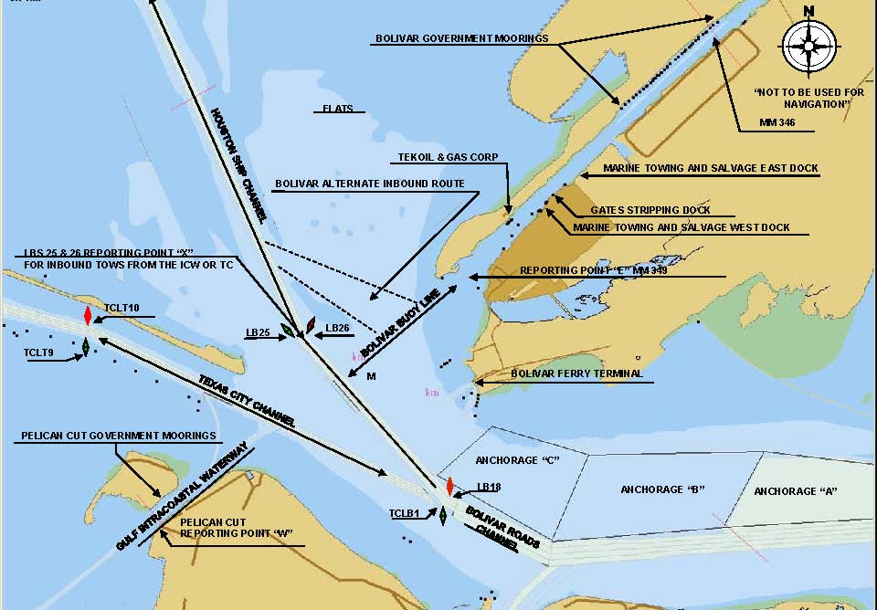
Figure 1. Chart extract from Vessel Traffic Service (VTS) Houston-Galveston with location of collision circled in red.
As a result of the accident, the Naticina sustained an inset and tear in the hull plate approximately 16 feet by 1 foot in the No. 5 starboard ballast tank. The MMI 3024 sustained a small fracture in the steel plate at the port corner of the bow rake. No crewmembers on the Alliance or the Naticina were injured, and the accident caused no pollution or disruption to other vessel traffic in the area. The U.S. Coast Guard served as lead Federal agency in the investigation of this accident, and the National Transportation Safety Board (NTSB) was a participant in the investigation.
Vessel Information
Alliance
The Alliance is a U.S.-flagged, uninspected towing vessel owned and operated by Higman Barge Lines, Inc., of Houston, Texas (see figure 2). The vessel was built in 2008 and is 72 feet long and 30 feet in beam with an operational draft of about 9 feet. Two diesel engines rated at 1,000 horsepower each propel the vessel. At the time of the accident, it was crewed by one licensed master, one licensed mate, one deckhand, and one tankerman. According to the master, the Alliance had no reported mechanical problems during the transit.
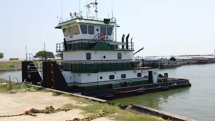
Figure 2. Uninspected towing vessel Alliance, postaccident.
Naticina
The Naticina is a Marshall Islands-flagged, Suezmax,[4] double-hulled tankship chartered by STASCO and operated by STASCO Ship Management. The vessel is 900 feet in length and 150 feet in beam, with a draft of about 30 feet in the ballast condition, as seen in figure 3. Propulsion was from a single direct-drive diesel engine rated at 25,000 shaft horsepower. The keel of the Naticina was laid in December 2008 at China Rongsheng Heavy Industries Group Holdings Limited, and the vessel was delivered for service in March 2010. At the time of the accident, the vessel was manned by a crew of 24 with mariner credentials issued by the Marshall Islands and two pilots from the Galveston-Texas City Pilots Association operating under the authority of their Texas state pilot's licenses.

Figure 3. Tankship Naticina at Galveston Fairway Anchorage, postaccident.
MMI 3024 and MMI 3025
The MMI 3024 (shown in figure 4) is an unmanned, double-skinned, non-self-propelled 1,619-gross-registered-ton (GRT) tank barge, built in 2000 by Trinity Industries, Inc., and owned and operated by Higman Barge Lines. The tank barge is 297 feet in length and 54 feet in beam and had a draft of 8 feet 6 inches. At the time of the accident, the tank barge was loaded with 20,000 barrels of mixed xylene.[5] A nearly identical tank barge, the MMI 3025, also laden with mixed xylene, was configured between the towing vessel Alliance and the MMI 3024 at the time of accident and was not damaged. The entire tow length of the two barges and the Alliance was approximately 666 feet.

Figure 4. Tank barge MMI 3024 at repair facility, postaccident.
Accident Description and Timeline of Events
The tug Alliance departed Corpus Christi bound for Texas City's BP refinery. On the day of the accident, the mate of the Alliance was on duty when the master awoke at 0530. The master reported that when he came to the bridge at 0600, the Alliance was heading northeast at mile 346 of the GIWW. He stated that the weather was clear, with 7 to 8 miles of visibility. The master relieved the mate and assumed control of the tug and two barges, which continued their northbound passage. The master said he transited this area approximately six or seven times a month.
Two Galveston-Texas City pilots separately boarded the tankship Naticina at approximately 0630 and 0640. At that time, the vessel was moored at the Seaway Crude Pipeline Company terminal and pump station after discharging its cargo of Castilla blend crude oil[6] and loading water ballast. Due to the pilots association working rules, two pilots were assigned for the vessel movement.[7] The first pilot directed the vessel's undocking and initial progress out of the Port of Texas City basin area. At an agreed-upon location, the first pilot transferred navigational control to the second pilot until the vessel reached the sea buoy.
Upon boarding, both pilots and the master of the Naticina held a master-pilot exchange conference to review the vessel's particulars and the departure plan. They discussed the vessel's draft, maneuvering characteristics, and propeller characteristics.[8] No steering, propulsion, navigational, or other equipment failures were reported to the pilots by the vessel's navigation crew or experienced during the outbound transit. The vessel was equipped with bridge-to-bridge very-high-frequency (VHF) radiotelephones, two automated radar plotting aids (ARPA), an automatic identification system (AIS), and electronic chart display and information systems (ECDIS). A portable piloting unit[9] brought on board by the second pilot provided an additional electronic positioning system.
As the Naticina departed, the bridge team consisted of two pilots, the master, the second mate, and an able-bodied seaman as helmsman. The first pilot handled the departure, giving directions to the bridge team. The vessel turned and entered the Texas City Channel outbound for sea.
The master of the Alliance first saw the Naticina when the tankship was outbound at buoys 18 and 19, approximately 4 miles away, as the tug and barges entered the Pelican Cut area of the GIWW. The Alliance entered Pelican Cut at approximately 2.5 miles per hour.[10] The tankerman from the Alliance was working on the after barge, MMI 3025, and was carrying a handheld ultrahigh-frequency (UHF) radio to communicate with the master.
The master of the Alliance stated to investigators that he intended to stop and tie off at the Pelican Cut Government Moorings (see figure 1), but at 0745, when he learned no moorings were available, he changed his mind and decided to proceed.
As the Naticina was outbound at buoys 11 and 12, the first pilot heard the master of the tug Alliance make a VHF radio call in which he said the VTS informed him that three vessels were inbound and three vessels were outbound from Texas City. The Naticina and the Alliance would be meeting at the intersection of the Texas City Channel and the GIWW near Pelican Cut. According to recorded VTS transmissions, a passing agreement was reached between the first pilot on the Naticina and the master of the Alliance that the Alliance would "hold up" and let the Naticina cross ahead of the Alliance before heading across the Texas City Channel. The master of the Alliance confirmed that this agreement was reached when the Naticina was at buoys 11 and 12.
After making the agreement, the master of the Alliance reported that he reduced his speed from 5 knots to 3 knots.
The second pilot on the Naticina was aware of the passing agreement between the first pilot on the Naticina and the master of the Alliance. The second pilot called the Alliance by VHF radio "to reaffirm the agreement." Although other traffic was present, the second pilot believed that the crossing situation with the Alliance required his closest attention.
As agreed between the pilots, the first pilot transferred responsibility for navigational control to the second pilot as the Naticina approached buoys 9 and 10, approximately 1.3 nautical miles from the GIWW intersection. As the vessel steadied on a course of 116, the second pilot assumed control of the Naticina and slowed the vessel to approximately 7 or 8 knots (slow or dead slow). The second pilot recalled that the Naticina was approximately 50 feet to the right of the channel centerline. The master of the Naticina saw the Alliance off the starboard side and discussed the passing agreement with the second pilot. The pilot told the master, "We talked to him and he's going to wait there."
Shortly before 0800, the Naticina's bridge watch changed. The second mate was relieved by the third mate, and the helmsman was also relieved.
The master of the Alliance stated to investigators that he had been holding up just outside of the Texas City Channel. He reported that at about 0800 he began backing down.
The second pilot noticed that the tug Alliance was still moving ahead and called a second time to say that the Naticina would be passing by in a few minutes. AIS data at that time indicated that the Naticina's track had increasingly favored the starboard side of the channel. The second pilot determined that a risk of collision existed when the bow of the Naticina was approximately 200 to 300 feet away from the Alliance and its barges. He directed the helmsman to begin altering the course of the Naticina to port but was unable to leave the channel without running aground.[11] The second pilot called the Alliance again just before impact and asked if the Alliance was taking evasive maneuvers and backing down.
When interviewed by investigators, the second pilot on the Naticina stated that he attempted to use bank effect[12] to prevent the collision. He indicated he gave a series of helm commands intended to position the port bow close to the eastern bank of the channel and then use bow deflection to swing the vessel's stern away from the lead barge of the Alliance. Those verbal commands were recorded by the Naticina's voyage data recorder (VDR).
The master of the Alliance stated that as the Naticina got closer it "pushed a bunch of water out. So he kind of sent me to the side a little bit towards the green [indicating the east side of the channel, marked by green buoys]. And as he was coming up on me, the barges straightened up. Then that's when I started kind of diving toward him. He had me in his suction." Just before impact, the master of the Alliance stated he went full astern with the throttle, and the tankerman said he heard the engines of the Alliance revving to back up.
The tracklines of both the Naticina and the Alliance were recorded by each vessel's AIS.[13] The AIS antenna on the Alliance was located approximately 26 feet from the tow's bow and, overall, 620 feet aft of the bow of lead barge MMI 3024.[14] The Naticina AIS antenna was located approximately 781 feet from the bow of that vessel and approximately 46 feet inboard of the starboard hull. Given these distances, the AIS data support the position that the bow of the MMI 3024 was very near the western boundary of the Texas City Channel at the time of the accident and probably was encroaching into the channel.
The bow of the lead barge, MMI 3024, struck the Naticina at 0805 and punctured the No. 5 starboard ballast tank of the doubled-hulled Naticina.[15] The barge sustained only a minor fracture in the bow rake, and no product was released. No injuries were reported, and the waterway remained open to vessel traffic.
Both vessels reported the accident to VTS via VHF radio. The Naticina was ordered by VTS to anchor outside of Galveston and await Coast Guard investigators. The towing vessel Alliance was ordered to proceed and wait at Bolivar Moorings.
Postaccident Drug and Alcohol Tests
Crew of the Alliance
Breath alcohol content (BrAC) testing was conducted on board the Alliance for the master and the tankerman within 4 hours of the accident; the results for both individuals were negative. They also tested negative for the presence of dangerous drugs.
Pilots and Crew of the Naticina
BrAC tests performed for both Naticina pilots within 2 hours of the accident were negative. Laboratory test results from both pilots were also negative for the presence of dangerous drugs. BrAC testing performed for the master, second mate, third mate, and helmsman between 1130 and 1215 also were negative, as were their results for alcohol and dangerous drugs.
Personnel Information
Alliance
Master. The master of the Alliance, age 61, was operating under the authority of his Coast Guard license at the time of the accident. He held a master of towing vessels license that authorized operations upon the Great Lakes, inland waters, and western rivers, with an inland radar observer endorsement.[16] He had been in the maritime industry working as a master on towing vessels for 30 years. He had been employed by Higman Barge Lines, Inc., for 20 years, and most of his recent marine training was provided through the company. According to his 72-hour work/rest schedule provided to the Coast Guard, he served on the 0600-1200 and 1800-2400 watch rotations, and during the previous 4 days he slept and rested during his off-watch time. He also stated he wore reading glasses, was in fair health, and used the prescription medication albuterol sulphate (inhaler) for his asthma condition. He joined the vessel on August 5, 2011.
Naticina
Master. The master, a Croatian national, age 50, received formal maritime training at an academy in his home country and had approximately 30 years of sea time in various ranks. He had served in the position of master for 4 years and had made the outbound trip from Texas City to sea on two previous occasions on board the Naticina. He stated he felt rested on the morning of the accident, and according to the 72-hour work/rest schedule he provided to the Coast Guard, he went to bed the previous night between 2300 and 2400 and awoke between 0600 and 0700. He stated he was in good health and over the last 5 years had been taking antihypertension medication marketed under the names Lodoz and Lacipil.
Galveston-Texas City Pilots
First Pilot. The first pilot, age 41, graduated from Texas A&M in 1994 with a degree in marine transportation and received a Coast Guard-issued third mate's license. He served with Keystone Shipping in the ranks of third mate, second mate, and chief mate before receiving his Texas state commission as a deputy pilot in 2000 and as a pilot in 2002. He stated he was in good health and was not taking any prescription medications at the time of the accident. He came on duty the day prior to the accident and went to bed around 2100 or 2200 that night after bringing the Libramont in from sea to anchorage in Bolivar Roads. He stated he awoke around 0530 for the movement of the Naticina.
Second Pilot. The second pilot, age 39, also graduated from Texas A&M in 1994 with a degree in marine transportation and received a Coast Guard-issued third mate's license. He served in various positions on deck as a mate of offshore supply vessels, articulated tug and barge units, and mobile offshore drilling units before receiving his first class pilot endorsement in 1998. He stated he was in good health and at the time of the accident was taking prescription medications for minor medical conditions. He came on duty the day prior to the accident and went to bed around 2330 that night after bringing the vessel Valbruna in from sea to Texas City berth 11. He awoke around 0545 for the movement of the Naticina.
Weather, Tides, and Currents
According to National Weather Service data from Scholes International Airport, located about 6 miles southwest of the accident site, the wind was southwesterly at 4 knots, visibility was 10 miles, scattered clouds were observed at 2,000 feet above ground level, and the air temperature was 84° F. The NOAA Galveston Bay Entrance, North Jetty, weather station, located about 5 miles east-southeast of the accident site, reported mean wave heights less than 1 foot, water temperature of 87° F, low tide at about 1300, and high tide at about 0636.
Waterway Information
Texas City Channel
According to the Coast Pilot, Bolivar Roads, the general location where the accident occurred, is a large deepwater area that connects Galveston, the Texas City Channel, and the Houston Ship Channel (HSC) with the GIWW passing through it.[17] The Texas City Channel extends from Bolivar Roads through the lower end of Galveston Bay to the Texas City turning basin. The waterway is maintained at a width of 400 feet and a depth of 45 feet and is approximately 6.8 miles in length.[18]
Vessel Traffic Service Houston-Galveston
The section of the waterway where the accident occurred is known locally as Bolivar Roads and was monitored by VTS Houston-Galveston, located at Coast Guard Sector Houston, about 37 miles from the accident site.[19] Certain vessels transiting the waterway are required to check in with VTS before entering the VTS area and at designated reporting points in the waterway.[20]
The primary mission of VTS is to coordinate the safe and efficient transit of vessels upon the waterways served. VTS uses AIS, radar, closed-circuit television (CCTV), and VHF-FM radiotelephone to gather and disseminate vessel traffic information. The VTS is staffed 24 hours a day, 7 days a week. VTS provides mariners with information including position, identity, and intentions of vessels operating in the VTS area; meteorological information; status of aids to navigation; traffic congestion; and waterway restrictions. VTS also offers navigational assistance, at the request of the vessel operator, by providing information about the operator's own vessel, such as course and speed, position in the waterway relative to the channel axis, landmarks, aids to navigation, and the positions, intentions, and identities of surrounding vessel traffic.
VTS services to mariners are primarily advisory, but VTS controllers have the authority to issue outcome-based directions, such as the direction to the Naticina to proceed to anchorage. VTS controllers at Houston-Galveston work on VHF radio channels 11, 12, and 5A (alpha) and communicate daily with the Galveston-Texas City pilots and other mariners by radio.[21] The area monitored is divided into two sectors, with one sector managing traffic inbound on the HSC at Baytown Bend Light 111 and vessels north of that location. The other sector manages traffic outbound on the HSC at Baytown Bend Light 111 and vessels south of that location. At any given time, VTS controllers may be monitoring multiple vessels in their sector of responsibility displayed electronically on computer screens. VTS controllers do not monitor one target to the exclusion of other marine traffic unless circumstances warrant. AIS broadcasts specific information every 2 to 12 seconds from a moving vessel and every 3 minutes from a vessel at anchor. The AIS signal is received ashore by the VTS and processed with radar and other data to provide the VTS controller with usable, vessel-specific data on screen with a delay of about 1 second.
On the morning of August 17, 2011, a VTS controller was monitoring the section of the waterway where the accident occurred, and both the Alliance and Naticina were checked into the traffic system using the designated channel 12 VHF for communications. The first pilot on the Naticina had initially checked in with VTS at about 0655 to inform the VTS controller of transit intentions.[22] The master of the Alliance checked in with VTS at about 0728, approximately 2 nautical miles from the intersection, and received a traffic advisory that included information about the outbound Naticina.[23] About 0746, the pilot on the Naticina checked in with VTS to provide the controller with a position report and obtained an updated traffic advisory. That VTS traffic advisory included the Alliance's intent to transit through the intersection from Pelican Cut to Bolivar Moorings.[24] After this, there were no further radio communications between the VTS and either vessel prior to the accident.
At about 0748, the master of the Alliance issued a broadcast to all vessels on VHF channel 13 in which he stated his intentions to hold up in Pelican Cut and wait for all traffic to clear. The second pilot on the Naticina contacted the master of the Alliance on VHF channel 13 at about 0755 to confirm his intentions. The master of the Alliance informed the pilot that he was "holding up … waiting for you [Naticina] to clear."
During his interview for this investigation, the VTS controller who had responsibility for the sector at the time of the accident stated he overheard the Alliance master broadcast on VHF channel 13 to all vessel traffic in the area that the vessel was holding position in Pelican Cut and waiting for all traffic to clear. The VTS controller also overheard a followup communication on the same frequency from the second pilot on the Naticina to the Alliance in which the master reconfirmed his intention to hold position. Based upon those radio transmissions, the VTS controller understood both vessels had agreed upon a passing arrangement in which the Alliance would cross the Texas City Channel astern of the Naticina.
Around 0808, the second pilot on the Naticina contacted VTS on VHF channel 12 to report the accident. The master on the Alliance contacted VTS on the same frequency at 0810 to report his vessel had been pulled into the Naticina by the suction effect.[25] VTS CCTV did not capture any images of the accident.
Postaccident Actions
Higman Barge Lines, Inc.
Higman Barge Lines, Inc., reviewed the facts in this matter under its Incident Management Review process, discussed the situation in person with the master of the Alliance, and took corrective personnel action toward the master. Higman Barge Lines, Inc., is also considering using the accident scenario as a training tool at a local maritime simulator where company personnel train.
Coast Guard
As part of the Coast Guard's marine casualty investigation process, Marine Safety Unit Texas City is analyzing causal factors to determine the viability of remedial actions to assist in preventing recurrences. These actions may include changes in waterway management or suspension or revocation of the right of the mariners involved to possess Coast Guard mariner credentials.
Shell International Trading and Shipping Company
Shell completed an enhanced navigation audit on the entire bridge team on board the Naticina and amended the company's safety management system (SMS) passage plan form. These amendments include capturing a planned speed for each leg of the transit and adding a remarks section for cautionary notes. The facts surrounding this incident were shared with the entire company fleet for awareness.
Galveston-Texas City Pilots
The Galveston-Texas City Pilots Association did not provide the NTSB with input on any postaccident actions taken by the association.
Noncausal Factors
The NTSB determined that qualifications of the crewmembers and both state pilots on board the Naticina and crewmembers aboard the Alliance were appropriate for the positions they held. Based on data gathered by investigators, neither work/rest schedules nor the use of alcohol, illicit drugs, or prescribed medications by the master and tankerman on the Alliance or the pilots and master on the Naticina were factors in this accident. Additional noncontributing factors included meteorological conditions; channel and waterway configurations; and functioning of propulsion, mechanical, and electronic navigational and communications systems on the Alliance and Naticina.
Probable Cause
The National Transportation Safety Board determines that the probable cause of the collision was the encroachment by the master of the Alliance and its two barges into the Texas City Channel and into the path of the Naticina despite the crossing agreement.
Notes
- All times are stated using the 24-hour clock, CDT (Universal Time Coordinated [UTC] - 5 hours).
- The Texas City Channel is a deep-draft navigation project serving the port of Texas City in Galveston County, Texas. It is maintained by the U.S. Army Corps of Engineers at a project depth of 45 feet and width of 400 feet. See National Oceanographic and Atmospheric Administration (NOAA) Chart 11324 Galveston Bay Entrance, edition 37, August 2011.
- The GIWW, an inland navigable waterway maintained by the U.S. Army Corps of Engineers, runs approximately 1,050 miles from Brownsville, Texas, to Carrabelle, Florida, and is maintained at a project depth of 12 feet. See NOAA Chart 11324 Galveston Bay Entrance, edition 37, August 2011, and Chart 11322, Intracoastal Waterway Galveston Bay to Cedar Lakes, edition 32, November 2008.
- The term Suezmax, a common reference used for oil tankships, denotes that the ship has the largest measurements capable of safely transiting the Suez Canal.
- The standard barrel of 42 U.S. gallons is used within the United States as a measure of crude oil and other petroleum products. The barge's load of 20,000 barrels is equivalent to 840,000 gallons. Xylene is an isomer found in crude oil and produced as a clear liquid; it is commonly used as a solvent and considered toxic.
- Castilla blend is a heavy crude that results from mixing Castilla crude with other heavy crudes produced in the plains region of Colombia. Virgin naphtha is added as a diluent to Castilla blend to transport it using the oil pipeline system to the Port of Coveñas, where the crude was loaded on the Naticina.
- According to the second pilot, two Galveston-Texas City pilots are assigned on vessels longer than 850 feet while turning in the Port of Texas City basin and transiting the Texas City Channel..
- The Naticina has a standard, single-screw, right-handed propeller.
- A portable piloting unit (PPU) display is based on the Global Positioning System (GPS) and provides marine pilots real-time vessel position, heading, and velocity data and electronic charting to help them guide vessels through ports and waterways. A PPU may be independent of shipboard systems and may include such features as multiple GPS antennas, integrated AIS radio reception, ship-to-shore radio, onboard integration with ground-based systems as well as vessel systems, and handheld display capability.
- The Alliance master said the GPS unit of the towing vessel Alliance was set to miles per hour.
- Safe navigation of the Naticina was limited to the confines of the Texas City Channel. In this case, Inland Rule 9 applied, requiring that a vessel shall not cross a narrow channel or fairway if such crossing impedes the passage of a vessel that can safely navigate only within that channel or fairway.
- Bank effect occurs when water flows asymmetrically past the port and starboard sides of a vessel and deflects the bow away from the bank.
- At 2- to 12-second intervals on a moving vessel, the AIS automatically transmits vessel information, including the vessel's name, type, position, course, speed, navigational status, and other safety-related information to appropriately equipped shore stations, other vessels, and aircraft. The rate at which the AIS information is updated depends on vessel speed and whether the vessel is changing course. The AIS also automatically receives information from similarly equipped vessels.
- The length of each barge was 297 feet, for an approximate combined total length of 594 feet in front of the bow of the Alliance.
- Coast Guard National Command Center (NCC) Situation Report 1, August 18, 2011.
- U.S. Coast Guard Master's License, Serial No. 1212523, Issue No. 8.
- NOAA, U.S. Coast Pilot Volume 5, Chapter 10, 38th edition, 2010. The Coast Pilot, published in nine volumes, provides information supplementary to NOAA's nautical charts, including channel descriptions, anchorages, currents, tide and water levels, prominent features, pilotage, towage, weather, dangers, routes, traffic separation schemes, and Federal navigation regulations.
- NOAA Chart 11324, Edition 37, August 2011, Galveston Bay Entrance, Galveston and Texas City Harbors.
- The Bolivar Roads area is considered by VTS as a Precautionary Area. Per 33 Code of Federal Regulations (CFR) Part 161.2, a Precautionary Area is an area with defined limits where vessels must navigate with particular caution and where the direction of traffic may be recommended. VTS Houston-Galveston has 14 of these Precautionary Areas identified in its operating area. See 33 CFR 161.35(b).
- VTSs utilize a regulatory Vessel Movement Reporting System to monitor and manage vessel movements. Per regulations governing VTS operations in the United States, VTS waterway users must provide a sailing plan report, position report, sailing plan deviation/amplification report, and final report to the VTS (33 CFR Part 161).
- VTS Houston-Galveston User Manual, revised July 2008.
- VTS Houston-Galveston Ship Transit Report for the Naticina.
- VTS Houston-Galveston Ship Transit Report for the Alliance.
- Information based on Coast Guard radio communication files captured by VTS Houston-Galveston and interview of VTS Houston-Galveston controller.
- VTS Houston-Galveston Incident Report HG086-11 dated August 17, 2011, with times denoted using date and time stamp from Coast Guard radio communication files.


