

New Surface Albedo Data Set Enables Improved Radiative Transfer Calculations
Download a printable PDF 
McFarlane, S. A., Pacific Northwest National Laboratory
Surface Properties
Cloud Life Cycle
McFarlane SA, K Gaustad, E Mlawer, C Long, and J Delamere. 2011. "Development of a high spectral resolution surface albedo product for the ARM Southern Great Plains central facility." Atmospheric Measurement Techniques, 4, 1713-1733.

Time series of daily percent vegetation derived from MFR measurements for (top) 2001-2008 at 10-m tower, which is located over an unmanaged pasture; (middle) 2001-2004 at 25-m tower, which is located over a managed field; and (bottom) 2005-2008 at 25-m tower. The different seasonal cycles at the 25-m tower are due to a change of crops between 2004 and 2005.
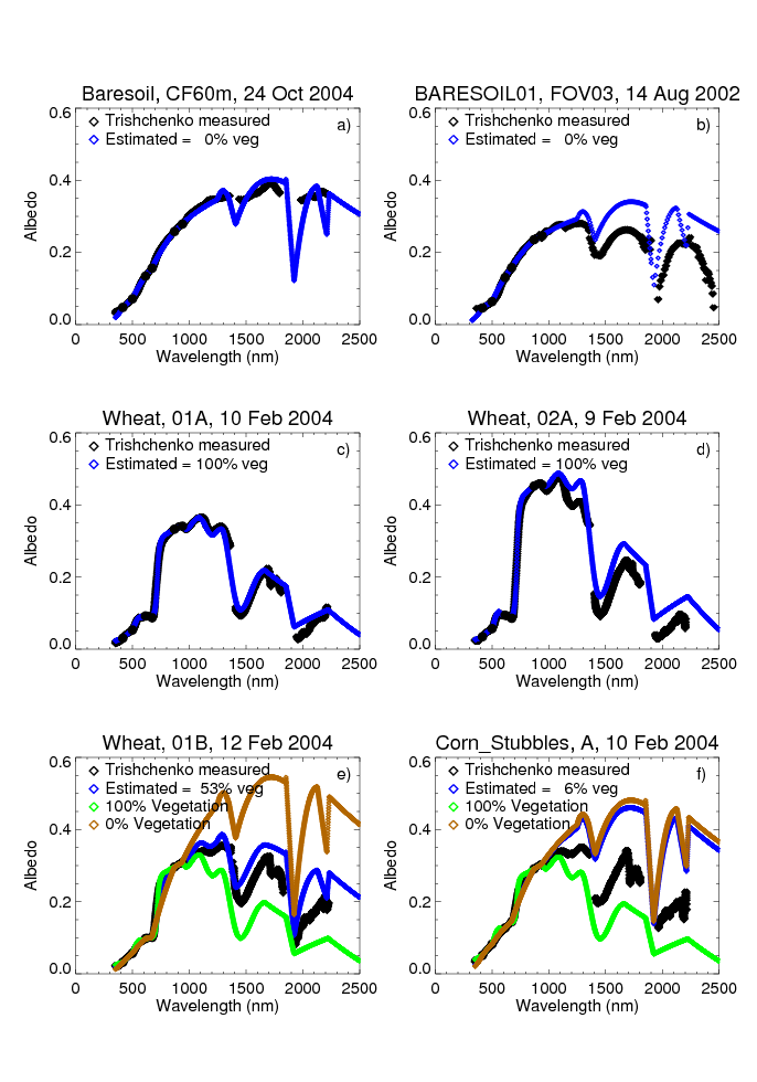
Examples of spectrally resolved albedo values from field study measurements (black diamonds) and new methodology (blue, green, or brown diamonds).
Surface albedo, the fraction of incoming sunlight reflected by a given surface, is an important component of the Earth’s energy balance. The amount of reflection of the various wavelengths of sunlight depends on the surface type (plants, soil, water) and can vary seasonally as vegetation characteristics and soil moisture change. To accurately model the impact of clouds and aerosols on the energy balance, and to interpret remote sensing measurements, accurate characterization of the reflectance with wavelength is needed.
At the Atmospheric Radiation Measurement (ARM) Southern Great Plains (SGP) site, surface albedo is measured at two locations by combining measurements of the incoming sunlight by upward-looking multifilter rotating shadowband radiometers (MFRSRs) with measurements of reflected sunlight by downward-looking multifilter radiometers (MFRs). These instruments measure surface albedo at six different wavelengths, providing some information on the variation across the solar spectrum. However, to perform detailed radiative transfer modeling, information on surface albedo at much higher spectral resolution and at longer wavelengths is needed.
We developed a methodology for using the six-wavelength albedo measurements at the SGP site to estimate the surface spectral albedo at high temporal and spectral resolution for all solar wavelengths. First, the measurements are used to identify the primary surface type (green vegetation, brown soil, mixed vegetation and soil, or snow) under the instruments. For mixed surfaces, the percentage of green vegetation is determined. Examination of the percent vegetation over several years shows different seasonal cycles over the two sites, illustrating the characteristics of the different vegetation types (grass and managed crops) at the two sites. For each surface type, functions defining the surface albedo as a function of wavelength are defined based on existing libraries containing detailed spectral measurements. Then the spectral function for the given surface type is scaled to match the MFR/MFRSR measurements at each time at the five given wavelengths.
The methodology is evaluated using detailed spectral measurements from several field campaigns performed at the SGP site. Radiative transfer calculations are performed to show the importance of using the spectrally resolved albedo rather than an average albedo to calculate the amount of scattered sunlight that reaches the surface.
A new methodology for calculating detailed spectrally resolved surface albedo from measurements at the ARM SGP site has been developed. This methodology has been used to produce a new ARM value-added product (VAP) data set for multiple years of data at the SGP site. The new data set will improve our ability to perform detailed radiative transfer calculations to quantify the effects of clouds and aerosols on the Earth’s energy balance.


