

Quantifying the Number of Independent Pieces of Information in Profiles
Download a printable PDF 
Crewell, S., University of Cologne
Atmospheric Thermodynamics and Vertical Structures
Radiative Processes
Lohnert U, DD Turner, and S Crewell. 2009. "Ground-based temperature and humidity profiling using spectral infrared and microwave observations. Part I: Simulated retrieval performance in clear-sky conditions." Journal of Applied Meteorology and Climatology, 48(5), 1017-1032.
Crewell S, K Ebell, U Loehnert, and DD Turner. 2009. "Can liquid water profiles be retrieved from passive microwave zenith observations?" Geophysical Research Letters, 36, L06803, doi:10.1029/2008GL036934.
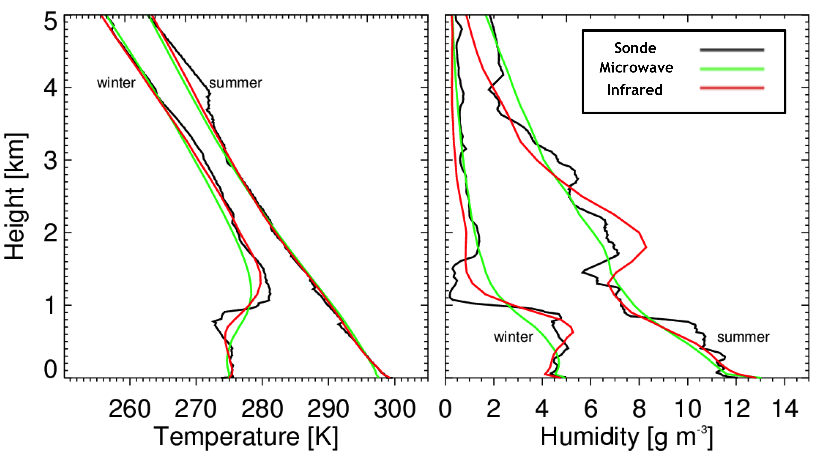
Figure 1: The retrieved profiles of temperature and humidity from the ground-based microwave and infrared remote sensing instruments, as compared against the radiosonde profiles that served at truth in the Loehnert et al. analysis. There are two cases shown, both drawn from the mid-latitude data set: a warm, moist summertime case and a dry, cold winter case. Note that the infrared retrieval does a better job capturing the structure in both the true temperature and humidity profile.
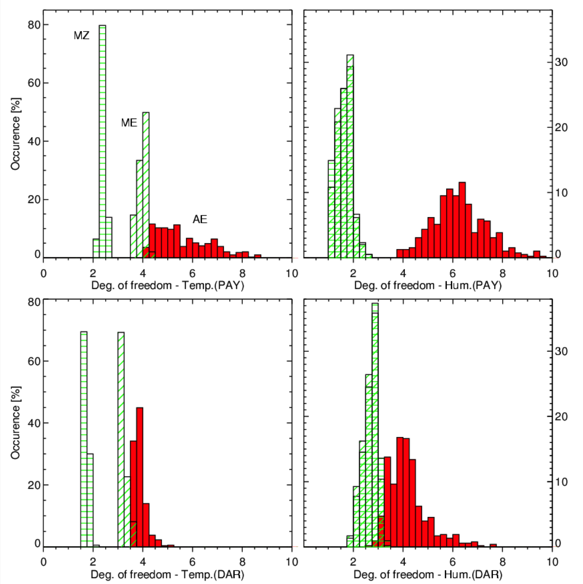
Figure 2: The degrees of freedom of signal in the microwave (zenith observations only [MZ] and zenith plus elevation scanning [ME]) and infrared (AE) observations from Payerne and Darwin sites, with temperature shown in the left-hand panels and humidity in the right-hand panels. The use of the elevation scans doubled the information content in the microwave retrievals. In most cases, the infrared retrievals have much larger information content than the microwave retrievals.
The atmospheric research community has a strong desire to use remotely sensed profiles of temperature and water vapor in a wide variety of research projects, because the temporal resolution of the remote sensors is typically much higher than is achieved with radiosonde and other traditional methods. Similarly, there is also a desire to profile the liquid water content in clouds, because the distribution of liquid water with height is important for a variety of studies, including characterizing the radiative impact of the cloud and predicting the impact of the entrainment of aerosols into the cloud. However, these profiles must be retrieved from the passive remote sensing observations, and these algorithms utilize a priori information in the retrieval process in order to constrain the inversion of the radiative transfer equation. Thus, there is the question of how much information on the vertical profile is provided by the remote sensing observations themselves, versus what is provided by the a priori information. These studies investigated the "information content" of the observations to derive the number of independent pieces of information in each of these profiles.
High spectral resolution microwave and infrared observations contain information on the vertical profile of temperature and water vapor. Loehnert et al. analyzed the information content (i.e., degrees of freedom of signal) of both approaches using a consistent data set that included clear-sky data from mid-latitude (Payerne, Switzerland) and tropical (Darwin, Australia) sites in order to span a large range of precipitable water vapor (PWV). Neither of these ground-based remote sensing approaches can match the vertical resolution of a radiosonde (e.g., Fig. 1), yet both methods are able to capture the broad features in the profiles to various degrees. Fig. 1 suggests that the spectral infrared data offer more information on the true profile than the spectral microwave data. This is confirmed with the information content analysis, wherein the degrees of freedom of signal from hundreds of profiles are summarized in Fig. 2 for both mid-latitude and tropical data. In virtually all cases, the spectral infrared data have a larger number of independent pieces of information in both the temperature and humidity profile than the spectral microwave data. However, these results are for clear sky cases; analysis of the information content of the infrared and microwave observations in cloudy conditions is currently being investigated.
There have been attempts by the scientific community to use passive remote sensing observations to determine the profile of liquid water content (LWC). Crewell et al. (2009) have demonstrated that at most one piece of independent information on the LWC profile is available for a zenith-pointing spectral microwave radiometer. This study demonstrates that adding higher frequencies (e.g., 90 and 150 GHz) to the typical microwave radiometer that observes multiple frequencies between 20 and 60 GHz does increase the information content slightly, but even in the best case the total number of independent pieces of information is still less than 1.3. Thus, Crewell et al. concluded that profiles of LWC cannot be retrieved from passive zenith-pointing microwave radiometers. This is a significant limitation, and a passive approach to profiling LWC would be advantageous to many different studies.
These two studies, and the follow-up efforts that are currently underway, illustrate the power of information content analysis to truly understand how much information resides in the remote sensing observations versus in the in situ data utilized in the retrieval. Characterizing the retrieval algorithms in this way prevents the misuse of the retrieved data, and also provides a strong statement on how the retrieved data should be used in future analyses.


