Sat, 13 Oct 2012 07:56:00 EDT
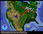
A storm over the northern/central Plains will move eastward to the Great Lakes by Sunday evening. Showers and thunderstorms will develop along and ahead of the associated front from the middle Mississippi valley to parts of the southern Plains on Saturday morning moving eastward to the Great Lakes/central Gulf Coast and trailing back along the western gulf coast by Sunday evening. In addition, light to moderate rain will develop over parts of the upper Great Lakes on Saturday morning also moving into parts of the northeast by Sunday. Rain and higher elevation snow will develop over parts of the central Rockies ending later Saturday evening. Upper-level energy and a plume of pacific moisture will trigger rain over parts of the Pacific Northwest inland to parts of the northern Rockies on Saturday.
Latest local weather forecasts, warnings, watches, and advisories...
Hydrometeorological Prediction Center Short Range Forecast Discussion


Sat, 13 Oct 2012 07:47:53 EDT
There is a slight risk of severe thunderstorms across portions of the southern and central Plains to portions of the Upper Mississippi Valley.
Details...
Yesterday's Storm Reports
National Hurricane Center Advisory

Sat, 13 Oct 2012 23:35:22 GMT
...CENTER OF RAFAEL NOW BETWEEN ST. MARTIN AND ST. CROIX...
Location: 17.9°N 63.5°W
Max sustained: 50 mph
Moving: N at 12 mph
Min pressure: 1004 mb
Issued at 800 PM AST SAT OCT 13 2012
Details...
Latest buoy reports
National Hurricane Center Advisory
Sat, 13 Oct 2012 20:36:32 GMT
...TROPICAL STORM PAUL FORMS WELL SOUTH-SOUTHWEST OF BAJA
CALIFORNIA...
Location: 14.0°N 113.6°W
Max sustained: 40 mph
Moving: W at 15 mph
Min pressure: 1005 mb
Issued at 200 PM PDT SAT OCT 13 2012
Details...
Latest buoy reports


Wed, 12 Sep 2012 10:55:33 EDT
The United States Department of Agriculture Drought Portal provides resources and information related to the current drought crisis from across the Government. Throughout much of the country, communities are struggling with one of the worst droughts to strike the U.S. in decades. The lack of rain and high temperatures have done considerable damage to crops -- particularly those in the Midwest. USDA and other federal agencies are taking steps to help farmers, ranchers, and small businesses wrestling with this crisis.
Details...
 News from NOAA
Lower 48 experiences warmer than average SeptemberTue, 9 Oct 2012 10:44:37 -0400
A new NOAA analysis finds that the average temperature for the contiguous U.S. during September was 67°F, 1.4°F above the long-term average. The January-September period was the warmest first nine months of any year on record for the contiguous United States. (
full report,
summary)
Details...