Science Features
 Loading Page...
Audio clip: Adobe Flash Player (version 9 or above) is required to play this audio clip. Download the latest version here. You also need to have JavaScript enabled in your browser.
Transcipt and Details
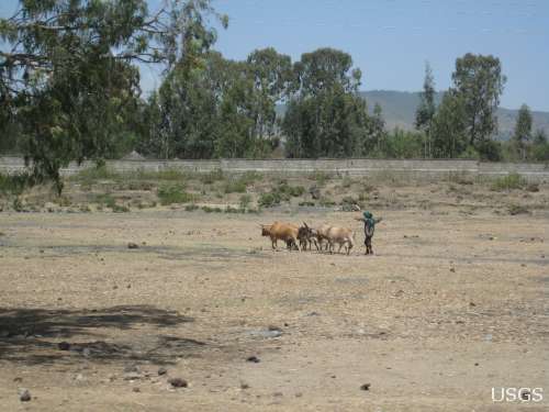
Young boys working in a newly cropped field in Africa.
In parts of eastern Africa, drought is of increasing concern, as poor families suffer from food shortages and the inability to grow crops and sustain livestock. Stunted growth in children due to malnutrition has also been linked to climate trends in Africa.
Drought conditions are expected to continue as global temperatures continue to rise and rainfall declines across parts of eastern Africa.
This poses increased risk to millions of people in Africa who currently face potential food shortages.
What’s being done to help?
The USGS is involved in a variety of research efforts to help understand current and future conditions in Africa, helping to inform plans to provide aid.
The Famine Early Warning Systems Network, or FEWS NET, is one endeavor that has already made great strides in helping to address this issue. FEWS NET helps target more than $1.5 billion of assistance to more than 40 countries each year.
FEWS NET examines the populations of the developing world with the most food insecurity, identifying critical situations in which food aid will be needed. These are populations whose livelihoods are typically tied to subsistence rain-fed agriculture and pastoralism.
FEWS NET is sponsored by the U.S. Agency for International Development (USAID) Office of Food for Peace and the USGS is actively involved.
FEWS NET at the United Nations Climate Convention
A USGS presentation on FEWS NET will be a featured side event on November 30, 2011, at the United Nations 17th annual Conference of the Parties (COP-17) in Durban, South Africa. The convention’s purpose is to develop international agreements and a declaration of policies and practices for combating climate change and its impacts around the world.
A herder moves cattle through a barren landscape in eastern Africa.
Climate forecasts and remote sensing help spot future trouble
FEWS NET has developed its own climate services to provide decision makers with early identification of agricultural drought that might trigger food insecurity. Scientists use climate forecasts to develop forward-looking food security assessments that are based on expected agricultural outcomes for the season ahead.
Since networks of ground observation stations are often sparse or reported late in FEWS NET countries, satellite remote sensing of vegetation and rainfall fills in the gaps. Remote sensing from space allows for rapid, accurate assessments of a broad range of environmental and agricultural conditions. USGS scientists provide the technologies and expertise to support remote sensing for FEWS NET activities.
Early warning of famine in Somalia helps pre-position food supplies
On July 20, 2011, the United Nations declared parts of Somalia as a region of famine. The decision was supported by FEWS NET and USGS observational evidence of conditions in the area.
The declaration was the culmination of early warning communications encouraging — months before the crisis — that government and other agencies pre-position food and supplies in the region.
“None of the many uses of Earth-observing satellites is more vital — or has as much potential for prompting timely humanitarian intervention — as famine early warning,” said USGS Director Marcia McNutt. “Remote sensing from space allows USGS scientists to provide rapid, accurate assessments of a broad range of environmental and agricultural conditions.”
The eastern Horn of Africa, the continental region that encompasses Somalia, has experienced two consecutive seasons of very poor rainfall resulting in the worst drought in 60 years. Crops have failed, livestock deaths are widespread, and food prices are very high. While the rains this winter have been good, food prices remain high, and the food security situation remains insecure.
Stunted growth linked to malnutrition and climate change
Other USGS research is helping to identify the impacts of a changing climate on Africa’s people. Scientists recently discovered that malnutrition and dry hot living conditions are linked to stunted growth in Mali, West Africa.
USGS research found that Mali was becoming substantially warmer and a little bit drier. Scientists also knew that farmers and those who make a living raising sheep, cattle, goats, or camels were poor, and that stunted growth was occurring throughout Mali.
Scientists wondered if there could be a link between human health and increasingly warm and dry conditions.
To investigate, the USGS worked with the University of California, Santa Barbara, to study climate observations and demographic and health data. The Demographic and Health Survey program routinely compiles data from surveys in 90 countries to study trends in health and population. Scientists analyzed statistics on specific villages in Mali and found that there was a link between a warmer climate and increased stunting.
Population growth combined with the impacts of warming will further increase these health impacts.
Stunting was also linked to other factors, such as mother’s education and the water supply system. Women’s education, improved water supplies, and agricultural development could help to address malnutrition and stunting in Mali.
An article on this research was published in in the journal, Applied Geography, by San Diego State University, the University of California, Santa Barbara, and the USGS.

A Food Security Assessment in Somalia found severe impacts on livestock due to drought conditions.
Other studies underway
Other new research includes the discovery that the warming of the Indian and western Pacific oceans (which is linked to global warming) affects rainfall over large areas of the Horn of Africa. As the globe has warmed over the last century, the Indian Ocean and western Pacific have warmed especially fast.
The resulting warmer air and increased humidity over the Indian and western Pacific oceans produce more frequent rainfall in that region. The air loses its moisture during rainfall, and then flows westward and descends over Africa, leading to decreased rain in parts of eastern Africa. Trends toward increased frequency of drought that we are seeing now are likely to continue into the future as warming continues.
A few recent articles on this research were published in the journal, Climate Dynamics, by scientists with the USGS, the University of California, Santa Barbara, and Los Alamos National Laboratory. The most recent article concludes that global warming will lead to a decrease in rainfall during the summer monsoon season, from June to September, across southern Sudan, southern Ethiopia, and northern Uganda. Another article concluded that eastern Africa, particularly Kenya and southern Ethiopia, will also have a significant decrease in rainfall during the long-rains season from March to June.
USGS scientists are working hard to translate these technical studies into reports for decision makers. To date, they have completed summary fact sheets focused on Sudan and Kenya.
Scientists also found that some regions, like northern Ethiopia, are not getting drier due to current warming temperatures. Rainfall varies dramatically across all of eastern Africa, with high mountainous areas typically receiving many times the rainfall received in low-lying areas. Therefore, agricultural growth in these climatically safe regions could help offset rainfall declines in other locations.
Start with science
Scientists are looking at clues and changes in nature to understand the impacts of global warming. In Africa, impacts are seen across the landscape — on farms and even in humans.
By starting with science, well-informed decisions can be made to help Africa as it faces drought, famine, and health concerns.
FEWS NET partners include the USAID, Chemonics International, the USGS, NASA, NOAA, and the USDA. The Geography Department at the University of California, Santa Barbara, is a partner to the USGS in this effort.
Want more information?
Listen to a podcast interview with USGS scientists as they discuss ongoing efforts to understand conditions in Africa.

USGS vigilant for West Nile virus in wildlife through surveillance, research, and mapping.

Dust storms July 21-22 blinded motorists, grounded flights and knocked out electricity. What’s causing the dust storms?

Please comment on the USGS’ draft science strategies! Read more

While on your spring hike, beware of hitchhiking ticks—they may carry Lyme Disease.

For the first time since its discovery, White-nose syndrome has been found in the West.

The family picnic: food and fun...until unwanted guests show up! Learn what you can do to prevent West Nile virus from infecting your loved ones.

Timing is everything! Consider helping track changes in spring’s arrival

Flood Safety Awareness Week is March. 12-16. What can you do to prepare?

National Groundwater Awareness Week is Mar. 11-17, 2012. See how USGS science is connecting groundwater and surface water.

Since Japan’s March 11, 2011, Tohoku earthquake and subsequent tsunami, scientists at the USGS have learned much to help better prepare for a large earthquake in the United States.

Five USGS employees honored with Distinguished Service Awards for their service to the nation

It’s National Invasive Species Awareness Week. Did you know invasive species cost our country more than 100 billion dollars each year? Get to know America’s ten top invaders this week.

Groundwater in aquifers on the East Coast and in the Central U.S. has the highest risk of contamination from radium, a naturally occurring radioactive element and known carcinogen.

The proposed USGS budget reflects research priorities to respond to nationally relevant issues, including water quantity and quality, ecosystem restoration, hydraulic fracturing, natural disasters such as floods and earthquakes, and support for the National Ocean Policy, and has a large R&D component.

Four new reports examine the contaminants polycyclic aromatic hydrocarbons (PAHs) found in house dust, streams, lakes, soil, and air.

It's only the beginning of their careers, but these 3 young scientists have forged ahead with innovative research at the frontiers of science. How they've transformed their fields

Oct. 9-15, 2011, is Earth Science Week, themed "Our-Ever Changing Earth," and Oct. 12, 2011, is International Day for Natural Disaster Reduction. Answers to questions posed by a changing world

By 1936, devastating losses of wildlife populations were threatening the Nation’s natural resource heritage. America's first wildlife research center

A dust storm on Tuesday, October 4, blinded motorists and caused a large string of motor vehicle crashes, multiple injuries, and at least one death. What’s causing the dust storms?

As the team of responders struggled to end the worst oil spill in our Nation’s history, USGS scientist Paul Hsieh provided the critical scientific information needed to make a crucial decision.

The movie Contagion dramatizes the scenario of a global pandemic that begins with the spread of a disease from animals to humans. What are real-life experts doing to prevent a pandemic that originates with wildlife?

On September 11, 2001, as the twin towers of the World Trade Center exploded and collapsed, clouds of dust billowed into the sky and across the city.
Forests play a significant role in removing carbon from the atmosphere by absorbing one-third of carbon emissions annually. This is according to a new U.S. Forest Service study conducted in collaboration with USGS scientists.
USGS crews continue to measure streamflow and collect water quality and sediment samples in the Ohio and Mississippi River basins using state-of-art instruments.
Ten gangly, adolescent whooping cranes have been released in Louisiana, marking a milestone for the USGS, the State of Louisiana, and the whooping cranes. The USGS has the largest breeding flock in the U.S., at about 60 birds. About half of these USGS-raised birds are returned to the wild each year.
Human health, ecological health, and environmental health are closely connected. Join us to learn how USGS science contributes to our understanding of how such environmental factors affect health threats.
Looking for information on natural resources, natural hazards, geospatial data, and more? The USGS Education site provides great resources, including lessons, data, maps, and more, to support teaching, learning, K-12 education, and university-level inquiry and research.
The Chesapeake Bay has long been an R&R destination for DC residents. However, the watershed’s overpopulation contributes to its decline. Join us when USGS’s Scott Phillips and Peter Claggett discuss new science efforts applied to restoring the Nation's largest estuary on October 6th.
USGS scientists help land managers determine if fire is the appropriate strategy for controlling or enhancing specific plant species.
Pharmaceutical manufacturing facilities can be a significant source of pharmaceuticals in surface water. The USGS is working with water utilities to try to reduce the release of pharmaceuticals and other emerging contaminants to the environment.
The United States Group on Earth Observations (USGEO) is working to connect Earth observations with public health, agriculture, climate, and data management and dissemination.
The USGS Science Strategy is a comprehensive report to critically examine the USGS's major science goals and priorities for the coming decade. The USGS is moving forward with these strategic science directions in response to the challenges that our Nation's future faces and for the stewards of our Federal lands.

The world's longest-running Earth-observing satellite program.
Dust storms July 21-22 blinded motorists, grounded flights and knocked out electricity. What’s causing the dust storms?

The majority of the nation is facing dry conditions; in most areas drought conditions are expected to persist or intensify. Read more
A contest to celebrate 40 years of Landsat. Read more
Please comment on the USGS’ draft science strategies! Read more
Timing is everything! Consider helping track changes in spring’s arrival
Need a historical map for your genealogy research? You are in luck. We’ve got what you need! Download and view USGS historical maps from the comfort of your own home.
Flood Safety Awareness Week is March. 12-16. What can you do to prepare?
National Groundwater Awareness Week is Mar. 11-17, 2012. See how USGS science is connecting groundwater and surface water.
Since Japan’s March 11, 2011, Tohoku earthquake and subsequent tsunami, scientists at the USGS have learned much to help better prepare for a large earthquake in the United States.
Five USGS employees honored with Distinguished Service Awards for their service to the nation

The USGS and UNESCO have produced a book that gives us a new way to look at our shared global heritage.
Groundwater in aquifers on the East Coast and in the Central U.S. has the highest risk of contamination from radium, a naturally occurring radioactive element and known carcinogen.
The proposed USGS budget reflects research priorities to respond to nationally relevant issues, including water quantity and quality, ecosystem restoration, hydraulic fracturing, natural disasters such as floods and earthquakes, and support for the National Ocean Policy, and has a large R&D component.

Caribou expert Layne Adams discusses the lives of reindeer — apart from their famous role on Christmas Eve. How they survive the cold.

As demand grows, Landsat data can help us track trends in key resources. Remote-sensing satellites help scientists to observe our world, monitor changes, and detect critical trends in forestry, water, crops, and urban landscapes. Learn more.
A new study provides crucial information for difficult decisions regarding conservation, economic interests, and food and water security. Projected changes for 2010-2099
It's only the beginning of their careers, but these 3 young scientists have forged ahead with innovative research at the frontiers of science. How they've transformed their fields
Oct. 9-15, 2011, is Earth Science Week, themed "Our-Ever Changing Earth," and Oct. 12, 2011, is International Day for Natural Disaster Reduction. Answers to questions posed by a changing world
By 1936, devastating losses of wildlife populations were threatening the Nation’s natural resource heritage. America's first wildlife research center
A dust storm on Tuesday, October 4, blinded motorists and caused a large string of motor vehicle crashes, multiple injuries, and at least one death. What’s causing the dust storms?
USGS scientists study walruses off the northwestern Alaska coast in August as part of their ongoing study of how the Pacific walrus are responding to reduced sea ice conditions in late summer and fall.
USGS scientists are collecting water samples and other data to determine trends in ocean acidification from the least explored ocean in the world.
In support of the Famine Early Warning Systems Network, USGS scientists use satellite remote sensing to assess agricultural conditions that foretell famine.
New USGS research shows that rice could become adapted to climate change and some catastrophic events by colonizing its seeds or plants with the spores of tiny naturally occurring fungi. The DNA of the rice plant itself is not changed; instead, researchers are re-creating what normally happens in nature.
Now that field work has wrapped up at the Ice Age "Snowmastodon" fossil site near Snowmass Village, Colo., USGS and other scientists will begin work on unraveling the climate and environmental history of the area.
USGS scientists are studying the Earth’s conditions 3 million years ago to gain insight into the impacts of future climate. Join us Aug. 3 in Reston, Va., to learn how this information is used to better understand the magnitude of changes forecast for the end of this century.
USGS crews continue to measure streamflow and collect water quality and sediment samples in the Ohio and Mississippi River basins using state-of-art instruments.
Over the past four decades, about 14% of the ice and permanent snow of Washington's Mount Rainier has melted due to combined recent warming and reduced precipitation.
USGS science supports management, conservation, and restoration of imperiled, at-risk, and endangered species.
In a unique application of data, this year's report provides the nation's first assessment of birds on public lands and waters.
The USGS, NASA, and other organizations and Federal agencies are studying how climate change affects wildlife and ecosystems.

Using coral growth records and measurements of changing ocean chemistry from increased atmospheric CO2, USGS scientists are providing a foundation for predicting future impacts of ocean acidification and sea-level rise to coral reefs.
Increased dust storm activity may result from enhanced aridity in the Southwest, according to a USGS study.
Provide your input on the draft USGS Global Change Science Strategy by April 8, 2011.
Sea-ice habitats essential to polar bears would likely respond positively should more curbs be placed on global greenhouse gas emissions, according to a new modeling study published today in the journal, Nature.
Landscape photos taken in the same place but many years apart reveal dramatic changes due to human and natural factors. The USGS Desert Laboratory Repeat Photography Collection, the largest archive of its kind in the world, is 50 years old.
Decreasing pH and warming temperatures are changing ocean conditions and affecting coral and algal growth in South Florida. USGS scientists are conducting field measurements to learn more.
Many coastal wetlands worldwide including several on the U.S. Atlantic coast may be more sensitive than previously thought to climate change and sea-level rise in the this century.
USGS findings support recent predictions that climate change will stress ecosystems at lower elevations more than higher elevations. This information may guide future conservation efforts in helping decision makers develop regional landscape predictions about biological responses to climate changes.
The Earth as Art 3 collection, the latest set of Landsat satellite images selected for their artistic quality, reveals an intricate beauty in Earth’s natural patterns.
USGS scientists are investigating sea turtles and their habitats in Dry Tortugas National Park to provide insight that will be used as decision-support tools for managing coral ecosystems.
Looking for information on natural resources, natural hazards, geospatial data, and more? The USGS Education site provides great resources, including lessons, data, maps, and more, to support teaching, learning, K-12 education, and university-level inquiry and research.
The timing of animal migration and reproduction, and observing when plants send out new leaves and bear fruit, is increasingly important in understanding how climate change affects biological and hydrologic systems. Photo credit Copyright C Brandon Cole.
The United States Group on Earth Observations (USGEO) is working to connect Earth observations with public health, agriculture, climate, and data management and dissemination.
USGS studies the relationships among earth surface processes, ecological systems, understanding current changes in the context of prehistoric and recent earth processes, distinguishing between natural and human-influenced changes, and recognizing ecological and physical responses to changes in climate.
The USGS Science Strategy is a comprehensive report to critically examine the USGS's major science goals and priorities for the coming decade. The USGS is moving forward with these strategic science directions in response to the challenges that our Nation's future faces and for the stewards of our Federal lands.

7 p.m.—Public lecture (also live-streamed over the Internet)

After nearly 2 years of meticulous research, academic and government scientists confirmed that the 2010 oil spill had damaged local coral ecosystems

In recognition of World Forestry Day, let’s take a glimpse at USGS science to understand the fate of forests from climate change.

Join us on March 7 to learn about bat white-nose syndrome, which has killed an estimate 5 million bats, and to discuss the profound impacts this emergent wildlife disease may have in the 21st century.

The U.S. Geological Survey had a very busy 2011 — below are a few of our highlights from last year.

Scientists have discovered an outbreak of coral disease called Montipora White Syndrome in Kāneohe Bay, Oahu. The affected coral are of the species Montipora capitata, also known as rice coral.

Recent USGS research shows that climate, vegetation, groundwater recharge rate, and proximity of the contaminants to the water table can all affect and control natural removal rates.
USGS scientists will join thousands of scientists, managers, and decision makers in Boston this week to present new findings on toxics at the Society for Environmental Toxicology and Chemistry (SETAC) conference in the Hynes Convention Center, Nov. 13-17.

On Nov. 3, USGS scientists Patrick Barnard and William Ellsworth will present a public lecture in Menlo Park, CA, providing Bay Area residents information about USGS research in the San Francisco Bay Area, including recent discoveries beneath San Francisco Bay and ongoing studies to better understand earthquake probabilities and the potential hazards associated with strong ground shaking.

Taking advantage of USGS expertise in satellite telemetry, geospatial mapping and analysis and waterfowl migration monitoring, researchers have tracked waterfowl across Asia, Eastern Europe, and Africa and discovered new flu transmission links.

USGS is working in collaboration with numerous state and federal agencies and tribes to obtain approval for field trials with vaccine-laden, peanut-butter flavored baits and evaluate the safety and effectiveness of the vaccine in grasslands.

Psychedelically colored wolves depicted by thermal imaging will shed light on how mange affects the survival, reproduction and social behavior of wolves in Yellowstone National Park.

7 p.m.—Public lecture (also live-streamed over the Internet)

USGS-led survey finds that national wildlife refuges rate highly with visitors.

As the climate has warmed, many plants are starting to grow leaves and bloom flowers earlier. A new study published in the journal, Nature, suggests that most field experiments may underestimate the degree to which the timing of leafing and flowering changes with global warming.

Stressed agricultural lands may be releasing less of the moisture needed to protect the breadbasket of a continent.

Spring rains in the eastern Horn of Africa are projected to begin late this year and be substantially lower than normal.
In recognition of World Forestry Day, let’s take a glimpse at USGS science to understand the fate of forests from climate change.

A new study concludes that fossil fuel emissions are likely contributors to a substantial amount of organic carbon found on glaciers in Alaska. Fossil fuel emissions, which contain organic carbon, can speed up the rate of glacier melt when deposited on glacier surfaces. In addition, the organic molecules associated with these deposits can be transportedContinue Reading
The U.S. Geological Survey had a very busy 2011 — below are a few of our highlights from last year.

Despite news articles warning of large-scale releases of methane due to climate change, recent research indicates that most of the world’s gas hydrate deposits should remain stable for the next few thousand years.
Join us on February 1 to view the Earth from space, and discuss the profound impact Landsat has on many facets of our economy, safety, and environment.
Scientists have discovered an outbreak of coral disease called Montipora White Syndrome in Kāneohe Bay, Oahu. The affected coral are of the species Montipora capitata, also known as rice coral.
USGS scientists will join thousands of scientists, managers, and decision makers in Boston this week to present new findings on toxics at the Society for Environmental Toxicology and Chemistry (SETAC) conference in the Hynes Convention Center, Nov. 13-17.
On Nov. 3, USGS scientists Patrick Barnard and William Ellsworth will present a public lecture in Menlo Park, CA, providing Bay Area residents information about USGS research in the San Francisco Bay Area, including recent discoveries beneath San Francisco Bay and ongoing studies to better understand earthquake probabilities and the potential hazards associated with strong ground shaking.

Rivers and streams in the United States are releasing substantially more carbon dioxide into the atmosphere than previously thought.

Climate Change Impacts to Tribal Communities The USGS is working with Native American communities and organizations to understand climate change impacts to their land and neighborhoods. Projects include interviews with indigenous Alaskans to understand their personal observations of climate change, as well as studying how climate change is impacting sand dunes and posing risksContinue Reading

As climate changes, it affects the timing of when leaves emerge, the amount of foliage that grows as well as the timeframe when leaves begin to fall.

How will accelerated glacial melting over the next 50 years as a result of climate change affect the unique Gulf of Alaska and Copper River coastal ecosystems? USGS scientists are studying these processes and impacts.

USGS scientists are assessing the potential to remove CO2 from the atmosphere for storage in other Earth systems through a process called carbon sequestration.

![]() U.S. Department of the Interior |
U.S. Geological Survey
U.S. Department of the Interior |
U.S. Geological Survey
URL: www.usgs.gov/blogs/features/usgs_top_story/science-helping-to-save-lives-in-africa/
Page Contact Information: Ask USGS
Page Last Modified: September 14, 2011


